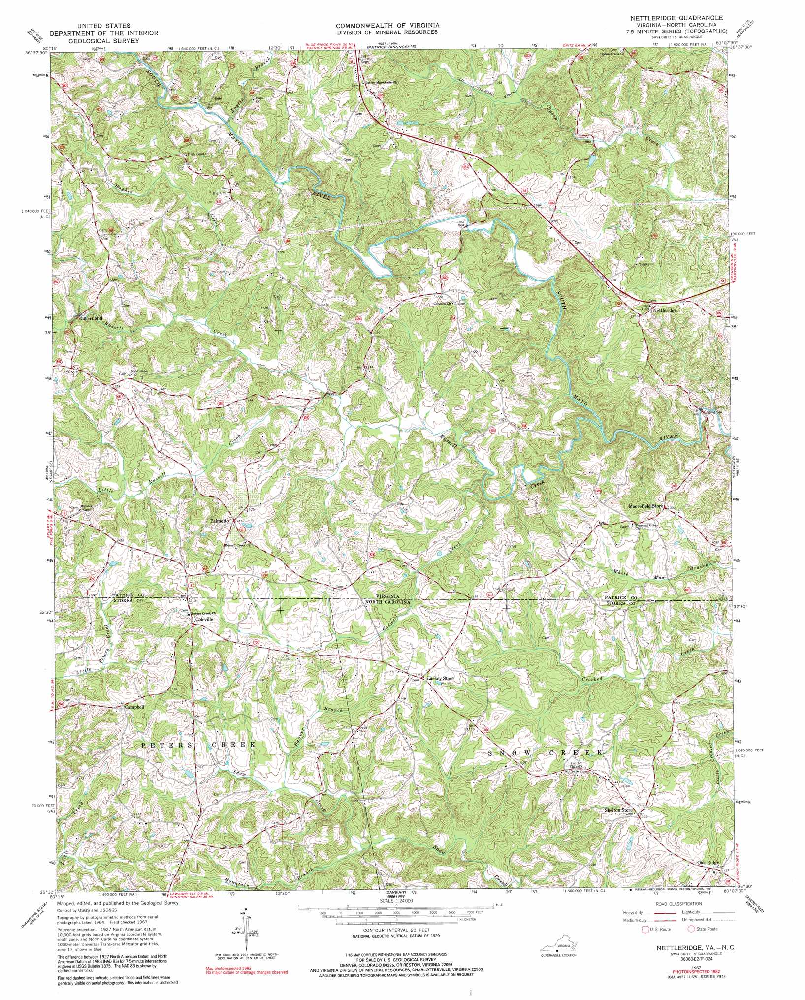
Nettleridge Topo Map Virginia
To zoom in, hover over the map of Nettleridge
USGS Topo Quad 36080e2 - 1:24,000 scale
| Topo Map Name: | Nettleridge |
| USGS Topo Quad ID: | 36080e2 |
| Print Size: | ca. 21 1/4" wide x 27" high |
| Southeast Coordinates: | 36.5° N latitude / 80.125° W longitude |
| Map Center Coordinates: | 36.5625° N latitude / 80.1875° W longitude |
| U.S. States: | VA, NC |
| Filename: | o36080e2.jpg |
| Download Map JPG Image: | Nettleridge topo map 1:24,000 scale |
| Map Type: | Topographic |
| Topo Series: | 7.5´ |
| Map Scale: | 1:24,000 |
| Source of Map Images: | United States Geological Survey (USGS) |
| Alternate Map Versions: |
Nettleridge VA 1967, updated 1968 Download PDF Buy paper map Nettleridge VA 1967, updated 1983 Download PDF Buy paper map Nettleridge VA 1967, updated 1991 Download PDF Buy paper map Nettleridge VA 2010 Download PDF Buy paper map Nettleridge VA 2013 Download PDF Buy paper map Nettleridge VA 2016 Download PDF Buy paper map |
1:24,000 Topo Quads surrounding Nettleridge
Willis |
Woolwine |
Charity |
Philpott Reservoir |
Bassett |
Meadows Of Dan |
Stuart |
Patrick Springs |
Sanville |
Martinsville West |
Claudville |
Stuart Se |
Nettleridge |
Spencer |
Price |
Pilot Mountain |
Hanging Rock |
Danbury |
Ayersville |
Mayodan |
Pinnacle |
King |
Walnut Cove |
Belews Lake |
Ellisboro |
> Back to 36080e1 at 1:100,000 scale
> Back to 36080a1 at 1:250,000 scale
> Back to U.S. Topo Maps home
Nettleridge topo map: Gazetteer
Nettleridge: Airports
Moorefields Airstrip elevation 327m 1072′Nettleridge: Dams
Jim Boaz Dam elevation 364m 1194′Nettleridge: Populated Places
Campbell elevation 347m 1138′Coleville elevation 366m 1200′
Gilbert Mill elevation 354m 1161′
Lackey Store elevation 349m 1145′
Nettleridge elevation 332m 1089′
Oak Ridge elevation 348m 1141′
Palmetto elevation 361m 1184′
Shelton Store elevation 342m 1122′
Nettleridge: Reservoirs
Jim Boaz Pond elevation 364m 1194′Nettleridge: Streams
Anglin Branch elevation 305m 1000′Banner Branch elevation 296m 971′
Cadwell Creek elevation 311m 1020′
Hughes Creek elevation 312m 1023′
Little Peters Creek elevation 314m 1030′
Little Russell Creek elevation 309m 1013′
Mountain Branch elevation 285m 935′
Noels Branch elevation 346m 1135′
Russell Creek elevation 295m 967′
Nettleridge digital topo map on disk
Buy this Nettleridge topo map showing relief, roads, GPS coordinates and other geographical features, as a high-resolution digital map file on DVD:
Western Virginia & Southern West Virginia
Buy digital topo maps: Western Virginia & Southern West Virginia