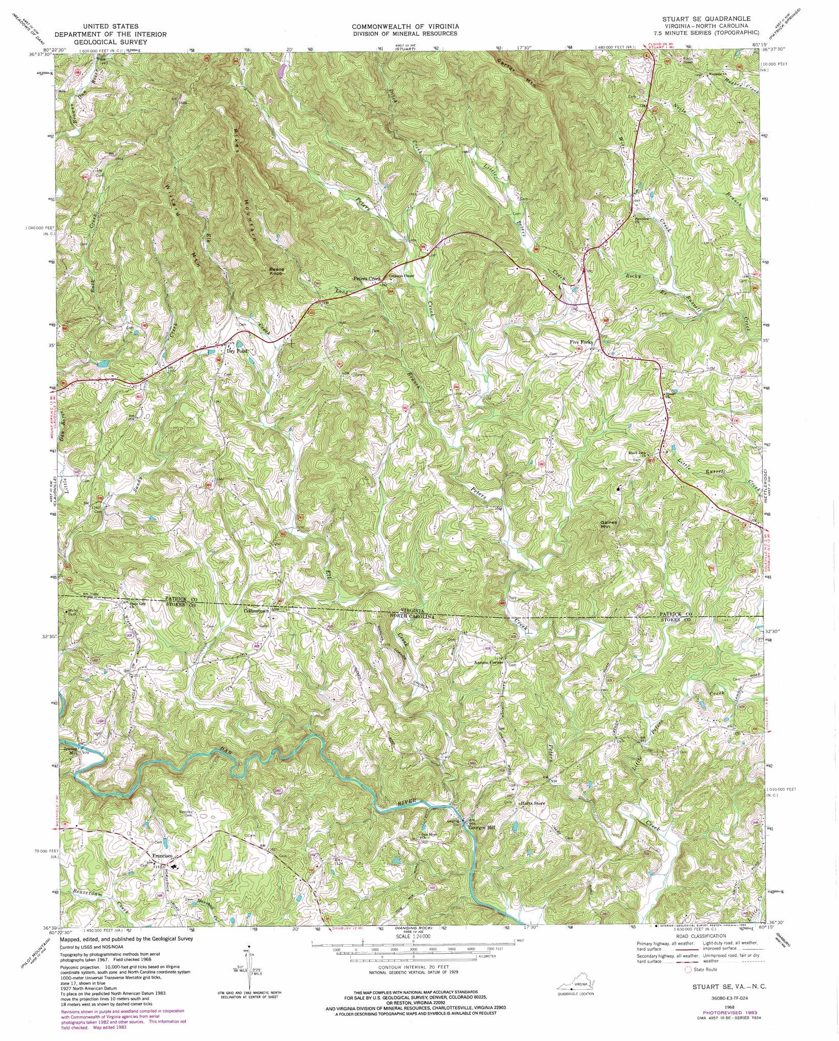
Stuart Se Topo Map Virginia
To zoom in, hover over the map of Stuart Se
USGS Topo Quad 36080e3 - 1:24,000 scale
| Topo Map Name: | Stuart Se |
| USGS Topo Quad ID: | 36080e3 |
| Print Size: | ca. 21 1/4" wide x 27" high |
| Southeast Coordinates: | 36.5° N latitude / 80.25° W longitude |
| Map Center Coordinates: | 36.5625° N latitude / 80.3125° W longitude |
| U.S. States: | VA, NC |
| Filename: | o36080e3.jpg |
| Download Map JPG Image: | Stuart Se topo map 1:24,000 scale |
| Map Type: | Topographic |
| Topo Series: | 7.5´ |
| Map Scale: | 1:24,000 |
| Source of Map Images: | United States Geological Survey (USGS) |
| Alternate Map Versions: |
Stuart SE VA 1968, updated 1970 Download PDF Buy paper map Stuart SE VA 1968, updated 1971 Download PDF Buy paper map Stuart SE VA 1968, updated 1984 Download PDF Buy paper map Stuart SE VA 2010 Download PDF Buy paper map Stuart SE VA 2013 Download PDF Buy paper map Stuart SE VA 2016 Download PDF Buy paper map |
1:24,000 Topo Quads surrounding Stuart Se
Dugspur |
Willis |
Woolwine |
Charity |
Philpott Reservoir |
Laurel Fork |
Meadows Of Dan |
Stuart |
Patrick Springs |
Sanville |
Mount Airy North |
Claudville |
Stuart Se |
Nettleridge |
Spencer |
Mount Airy South |
Pilot Mountain |
Hanging Rock |
Danbury |
Ayersville |
Siloam |
Pinnacle |
King |
Walnut Cove |
Belews Lake |
> Back to 36080e1 at 1:100,000 scale
> Back to 36080a1 at 1:250,000 scale
> Back to U.S. Topo Maps home
Stuart Se topo map: Gazetteer
Stuart Se: Parks
Byrds Marker elevation 315m 1033′Stuart Se: Populated Places
Aarons Corner elevation 339m 1112′Collinstown elevation 374m 1227′
Dry Pond elevation 407m 1335′
Five Forks elevation 425m 1394′
Francisco elevation 347m 1138′
Georges Mill elevation 256m 839′
Harts Store elevation 324m 1062′
Jessup Mill elevation 297m 974′
Peters Creek elevation 406m 1332′
Stuart Se: Streams
Ditch Creek elevation 383m 1256′Elk Creek elevation 255m 836′
Elk Creek elevation 255m 836′
Little Peters Creek elevation 352m 1154′
Little Peters Creek elevation 261m 856′
Long Branch elevation 340m 1115′
Rocky Branch elevation 368m 1207′
Sandy Creek elevation 325m 1066′
Witt Creek elevation 370m 1213′
Stuart Se: Summits
Beans Knob elevation 535m 1755′Gaines Mountain elevation 424m 1391′
Pikes Mountain elevation 629m 2063′
Willard Mountain elevation 569m 1866′
Stuart Se digital topo map on disk
Buy this Stuart Se topo map showing relief, roads, GPS coordinates and other geographical features, as a high-resolution digital map file on DVD:
Western Virginia & Southern West Virginia
Buy digital topo maps: Western Virginia & Southern West Virginia