Mount Airy North Topo Map Virginia
To zoom in, hover over the map of Mount Airy North
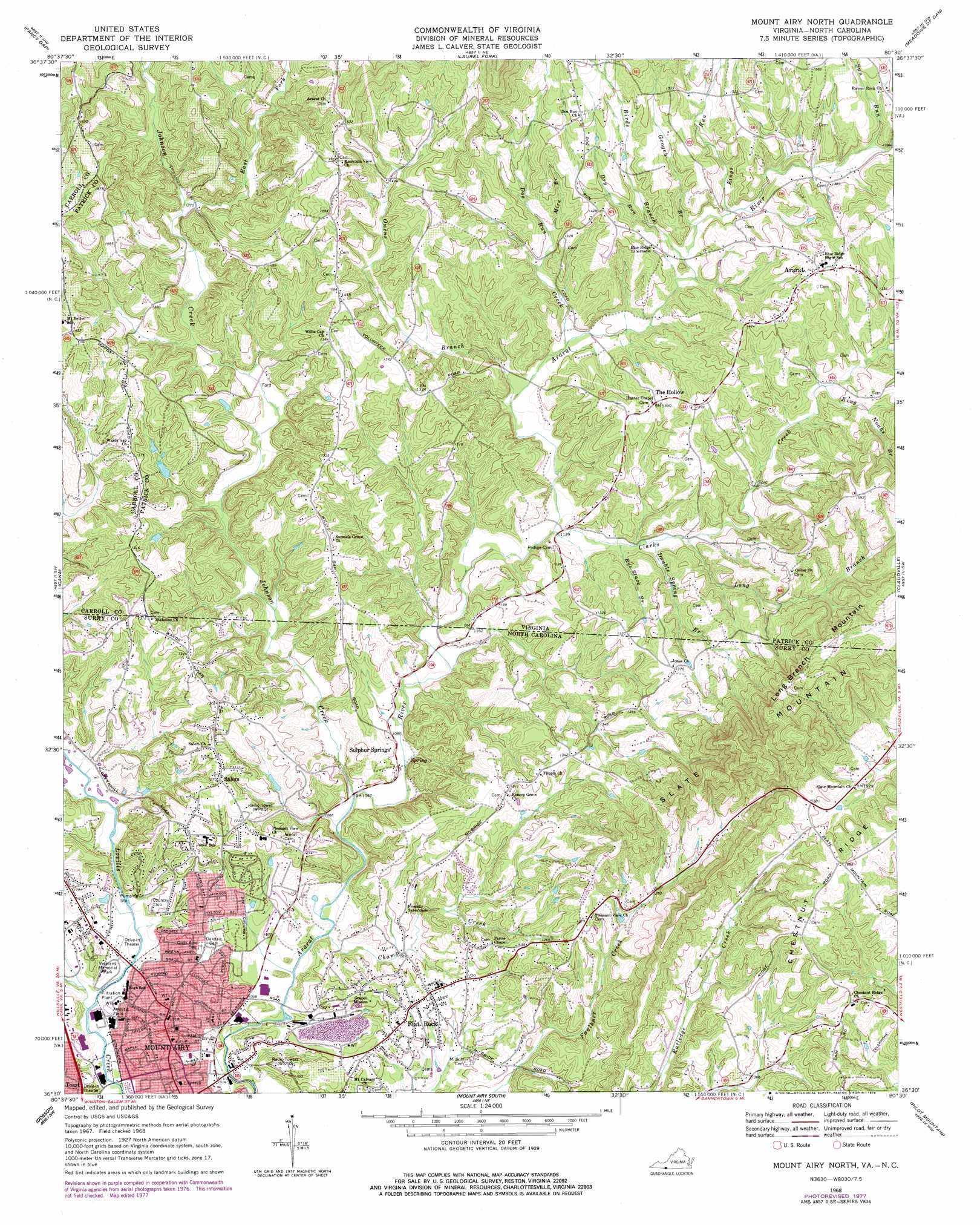
USGS Topo Quad 36080e5 - 1:24,000 scale
| Topo Map Name: | Mount Airy North |
| USGS Topo Quad ID: | 36080e5 |
| Print Size: | ca. 21 1/4" wide x 27" high |
| Southeast Coordinates: | 36.5° N latitude / 80.5° W longitude |
| Map Center Coordinates: | 36.5625° N latitude / 80.5625° W longitude |
| U.S. States: | VA, NC |
| Filename: | o36080e5.jpg |
| Download Map JPG Image: | Mount Airy North topo map 1:24,000 scale |
| Map Type: | Topographic |
| Topo Series: | 7.5´ |
| Map Scale: | 1:24,000 |
| Source of Map Images: | United States Geological Survey (USGS) |
| Alternate Map Versions: |
Mount Airy North NC 1968, updated 1971 Download PDF Buy paper map Mount Airy North NC 1968, updated 1978 Download PDF Buy paper map Mount Airy North NC 1968, updated 1978 Download PDF Buy paper map Mount Airy North NC 1976, updated 1979 Download PDF Buy paper map Mount Airy North NC 2010 Download PDF Buy paper map Mount Airy North NC 2013 Download PDF Buy paper map Mount Airy North NC 2016 Download PDF Buy paper map |
1:24,000 Topo Quads surrounding Mount Airy North
Sylvatus |
Hillsville |
Dugspur |
Willis |
Woolwine |
Woodlawn |
Fancy Gap |
Laurel Fork |
Meadows Of Dan |
Stuart |
Lambsburg |
Cana |
Mount Airy North |
Claudville |
Stuart Se |
Bottom |
Dobson |
Mount Airy South |
Pilot Mountain |
Hanging Rock |
Elkin North |
Copeland |
Siloam |
Pinnacle |
King |
> Back to 36080e1 at 1:100,000 scale
> Back to 36080a1 at 1:250,000 scale
> Back to U.S. Topo Maps home
Mount Airy North topo map: Gazetteer
Mount Airy North: Mines
Flat Rock Quarry elevation 329m 1079′Mount Airy North: Parks
Riverside Park elevation 309m 1013′Veterans Memorial Park elevation 317m 1040′
Mount Airy North: Populated Places
Ararat elevation 441m 1446′Combstown elevation 327m 1072′
Flat Rock elevation 349m 1145′
Salem elevation 386m 1266′
Slate Mountain elevation 465m 1525′
Sulphur Springs elevation 327m 1072′
Mount Airy North: Ridges
Chestnut Ridge elevation 511m 1676′Mount Airy North: Streams
Birds Branch elevation 379m 1243′Champ Creek elevation 313m 1026′
Clarks Creek elevation 346m 1135′
Doe Run Creek elevation 360m 1181′
Double Spring Branch elevation 351m 1151′
Double Spring Branch elevation 351m 1151′
Dry Run elevation 395m 1295′
East Fork Johnson Creek elevation 387m 1269′
Grogen Branch elevation 385m 1263′
Johnson Creek elevation 320m 1049′
King Noahs Branch elevation 378m 1240′
Kings Run elevation 361m 1184′
Long Branch elevation 353m 1158′
Mire Branch elevation 392m 1286′
Owens Branch elevation 354m 1161′
Rocky Creek elevation 312m 1023′
Rye Stack Branch elevation 348m 1141′
School House Creek elevation 324m 1062′
Sun Run elevation 417m 1368′
Mount Airy North: Summits
Long Branch Mountain elevation 497m 1630′Slate Mountain elevation 601m 1971′
Slate Mountain elevation 593m 1945′
Mount Airy North digital topo map on disk
Buy this Mount Airy North topo map showing relief, roads, GPS coordinates and other geographical features, as a high-resolution digital map file on DVD:
Western Virginia & Southern West Virginia
Buy digital topo maps: Western Virginia & Southern West Virginia