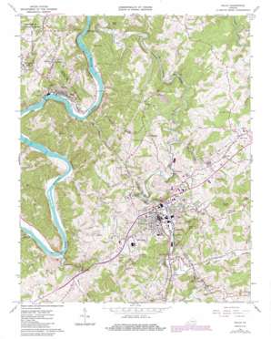
Galax Topo Map Virginia
To zoom in, hover over the map of Galax
USGS Topo Quad 36080f8 - 1:24,000 scale
| Topo Map Name: | Galax |
| USGS Topo Quad ID: | 36080f8 |
| Print Size: | ca. 21 1/4" wide x 27" high |
| Southeast Coordinates: | 36.625° N latitude / 80.875° W longitude |
| Map Center Coordinates: | 36.6875° N latitude / 80.9375° W longitude |
| U.S. State: | VA |
| Filename: | o36080f8.jpg |
| Download Map JPG Image: | Galax topo map 1:24,000 scale |
| Map Type: | Topographic |
| Topo Series: | 7.5´ |
| Map Scale: | 1:24,000 |
| Source of Map Images: | United States Geological Survey (USGS) |
| Alternate Map Versions: |
Galax VA 1965, updated 1967 Download PDF Buy paper map Galax VA 1965, updated 1971 Download PDF Buy paper map Galax VA 1965, updated 1978 Download PDF Buy paper map Galax VA 1965, updated 1984 Download PDF Buy paper map Galax VA 2011 Download PDF Buy paper map Galax VA 2013 Download PDF Buy paper map Galax VA 2016 Download PDF Buy paper map |
| FStopo: | US Forest Service topo Galax is available: Download FStopo PDF Download FStopo TIF |
1:24,000 Topo Quads surrounding Galax
> Back to 36080e1 at 1:100,000 scale
> Back to 36080a1 at 1:250,000 scale
> Back to U.S. Topo Maps home
Galax topo map: Gazetteer
Galax: Bridges
J R Carico Memorial Bridge elevation 670m 2198′Galax: Crossings
Blair Ferry (historical) elevation 646m 2119′Dickinson Ferry (historical) elevation 670m 2198′
Galax: Dams
Fries Mill Dam elevation 689m 2260′Galax: Gaps
Kenworthy Gap elevation 845m 2772′Galax: Parks
Felts Park elevation 718m 2355′Galax: Populated Places
Cliffview elevation 722m 2368′Cox Mill elevation 730m 2395′
Fries elevation 666m 2185′
Galax elevation 723m 2372′
Hebron elevation 786m 2578′
Hickory Flat elevation 794m 2604′
Hilltown elevation 763m 2503′
Oldtown elevation 777m 2549′
Reavistown elevation 694m 2276′
Stevens Creek elevation 751m 2463′
West Galax elevation 762m 2500′
Wolf Glade elevation 756m 2480′
Galax: Ridges
Iron Ridge elevation 810m 2657′Galax: Streams
Clear Fork elevation 689m 2260′Coal Creek elevation 726m 2381′
Daniel Branch elevation 711m 2332′
Dixon Branch elevation 659m 2162′
Eagle Bottom Creek elevation 657m 2155′
Glady Fork elevation 725m 2378′
Meadow Creek elevation 670m 2198′
Mill Creek elevation 694m 2276′
Miller Branch elevation 761m 2496′
Oglesby Branch elevation 675m 2214′
Redman Branch elevation 670m 2198′
Stevens Creek elevation 671m 2201′
Stout Branch elevation 652m 2139′
Town Branch elevation 676m 2217′
Wards Mill Branch elevation 719m 2358′
Galax: Summits
Bald Rock elevation 711m 2332′Coby Knob elevation 860m 2821′
Enoch Knob elevation 894m 2933′
McCamant Hill elevation 822m 2696′
Pilot Knob elevation 897m 2942′
Pope Knob elevation 911m 2988′
Stoneman Hill elevation 730m 2395′
Toby Knob elevation 718m 2355′
Ward Knob elevation 905m 2969′
Galax digital topo map on disk
Buy this Galax topo map showing relief, roads, GPS coordinates and other geographical features, as a high-resolution digital map file on DVD:
Western Virginia & Southern West Virginia
Buy digital topo maps: Western Virginia & Southern West Virginia


