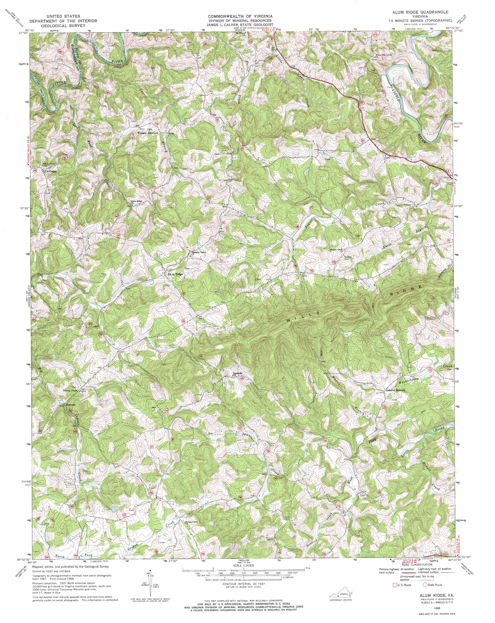
Alum Ridge Topo Map Virginia
To zoom in, hover over the map of Alum Ridge
USGS Topo Quad 36080h4 - 1:24,000 scale
| Topo Map Name: | Alum Ridge |
| USGS Topo Quad ID: | 36080h4 |
| Print Size: | ca. 21 1/4" wide x 27" high |
| Southeast Coordinates: | 36.875° N latitude / 80.375° W longitude |
| Map Center Coordinates: | 36.9375° N latitude / 80.4375° W longitude |
| U.S. State: | VA |
| Filename: | o36080h4.jpg |
| Download Map JPG Image: | Alum Ridge topo map 1:24,000 scale |
| Map Type: | Topographic |
| Topo Series: | 7.5´ |
| Map Scale: | 1:24,000 |
| Source of Map Images: | United States Geological Survey (USGS) |
| Alternate Map Versions: |
Alum Ridge VA 1968, updated 1971 Download PDF Buy paper map Alum Ridge VA 2010 Download PDF Buy paper map Alum Ridge VA 2013 Download PDF Buy paper map Alum Ridge VA 2016 Download PDF Buy paper map |
1:24,000 Topo Quads surrounding Alum Ridge
Staffordsville |
Radford North |
Blacksburg |
Ironto |
Elliston |
Dublin |
Radford South |
Riner |
Pilot |
Check |
Hiwassee |
Indian Valley |
Alum Ridge |
Floyd |
Endicott |
Hillsville |
Dugspur |
Willis |
Woolwine |
Charity |
Fancy Gap |
Laurel Fork |
Meadows Of Dan |
Stuart |
Patrick Springs |
> Back to 36080e1 at 1:100,000 scale
> Back to 36080a1 at 1:250,000 scale
> Back to U.S. Topo Maps home
Alum Ridge topo map: Gazetteer
Alum Ridge: Airports
Alum Ridge Stolport elevation 725m 2378′Deer Run Airport elevation 717m 2352′
Alum Ridge: Populated Places
Carthage elevation 733m 2404′Duncan elevation 744m 2440′
Laurel Branch elevation 740m 2427′
Wangle Junction elevation 743m 2437′
Alum Ridge: Ridges
Wills Ridge elevation 983m 3225′Alum Ridge: Streams
Dobbins Creek elevation 719m 2358′Earls Branch elevation 662m 2171′
Howell Creek elevation 690m 2263′
Laurel Branch elevation 608m 1994′
Lost Bent Creek elevation 607m 1991′
Sidney Creek elevation 625m 2050′
Spurlock Creek elevation 699m 2293′
Alum Ridge digital topo map on disk
Buy this Alum Ridge topo map showing relief, roads, GPS coordinates and other geographical features, as a high-resolution digital map file on DVD:
Western Virginia & Southern West Virginia
Buy digital topo maps: Western Virginia & Southern West Virginia