Max Meadows Topo Map Virginia
To zoom in, hover over the map of Max Meadows
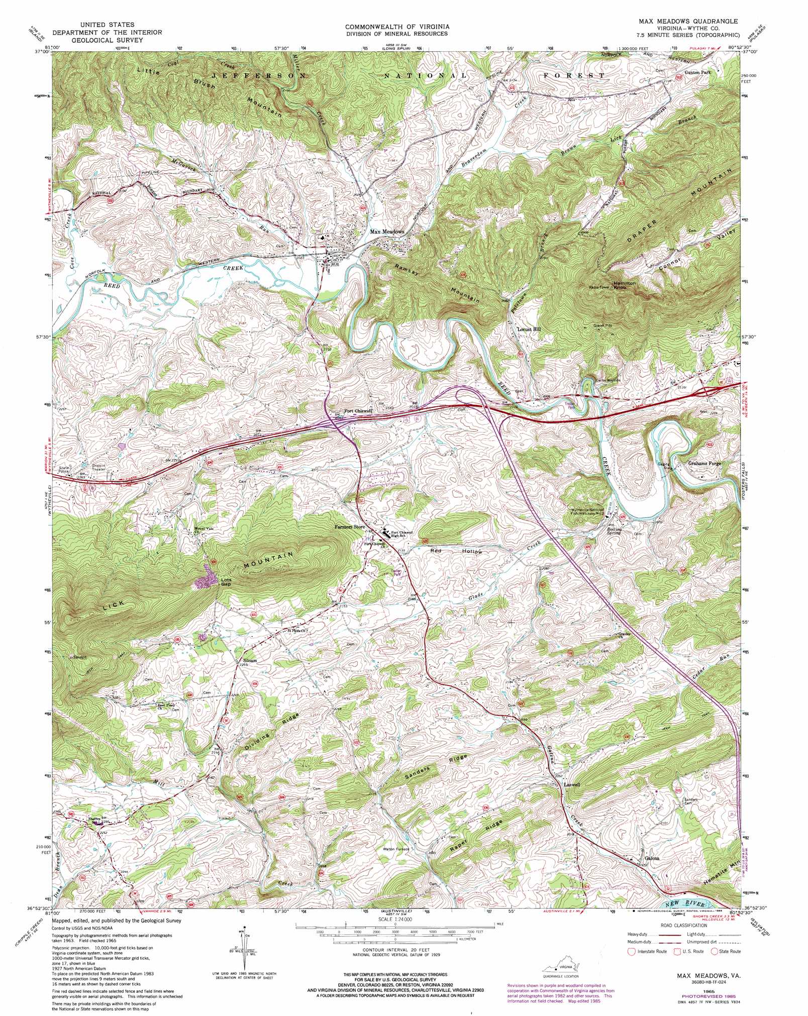
USGS Topo Quad 36080h8 - 1:24,000 scale
| Topo Map Name: | Max Meadows |
| USGS Topo Quad ID: | 36080h8 |
| Print Size: | ca. 21 1/4" wide x 27" high |
| Southeast Coordinates: | 36.875° N latitude / 80.875° W longitude |
| Map Center Coordinates: | 36.9375° N latitude / 80.9375° W longitude |
| U.S. State: | VA |
| Filename: | o36080h8.jpg |
| Download Map JPG Image: | Max Meadows topo map 1:24,000 scale |
| Map Type: | Topographic |
| Topo Series: | 7.5´ |
| Map Scale: | 1:24,000 |
| Source of Map Images: | United States Geological Survey (USGS) |
| Alternate Map Versions: |
Max Meadows VA 1965, updated 1968 Download PDF Buy paper map Max Meadows VA 1965, updated 1979 Download PDF Buy paper map Max Meadows VA 1965, updated 1986 Download PDF Buy paper map Max Meadows VA 1965, updated 1986 Download PDF Buy paper map Max Meadows VA 2011 Download PDF Buy paper map Max Meadows VA 2013 Download PDF Buy paper map Max Meadows VA 2016 Download PDF Buy paper map |
| FStopo: | US Forest Service topo Max Meadows is available: Download FStopo PDF Download FStopo TIF |
1:24,000 Topo Quads surrounding Max Meadows
Bastian |
Rocky Gap |
Mechanicsburg |
White Gate |
Staffordsville |
Big Bend |
Bland |
Long Spur |
Pulaski |
Dublin |
Crockett |
Wytheville |
Max Meadows |
Fosters Falls |
Hiwassee |
Speedwell |
Cripple Creek |
Austinville |
Sylvatus |
Hillsville |
Elk Creek |
Brierpatch Mountain |
Galax |
Woodlawn |
Fancy Gap |
> Back to 36080e1 at 1:100,000 scale
> Back to 36080a1 at 1:250,000 scale
> Back to U.S. Topo Maps home
Max Meadows topo map: Gazetteer
Max Meadows: Bends
Horseshoe Bend elevation 595m 1952′Max Meadows: Bridges
Keesline Bridge elevation 603m 1978′Max Meadows: Crossings
Interchange 32 elevation 643m 2109′Interchange 80 elevation 624m 2047′
Interchange 81 elevation 643m 2109′
Interchange 84 elevation 657m 2155′
Max Meadows: Gaps
Lots Gap elevation 765m 2509′Max Meadows: Parks
Carter Wayside elevation 602m 1975′Max Meadows: Populated Places
Clarkes Summit elevation 704m 2309′Coleman Store elevation 684m 2244′
Conners elevation 701m 2299′
Farmers Store elevation 662m 2171′
Fort Chiswell elevation 626m 2053′
Galena elevation 600m 1968′
Grahams Forge elevation 602m 1975′
Laswell elevation 623m 2043′
Locust Hill elevation 625m 2050′
Max Meadows elevation 618m 2027′
Poletown elevation 635m 2083′
Siloam elevation 687m 2253′
Walton Furnace elevation 635m 2083′
Max Meadows: Ridges
Dividing Ridge elevation 707m 2319′Raper Ridge elevation 694m 2276′
Sanders Ridge elevation 701m 2299′
Max Meadows: Springs
Boiling Spring elevation 603m 1978′Max Meadows: Streams
Beaverdam Creek elevation 613m 2011′Brown Lick Branch elevation 630m 2066′
Coal Creek elevation 641m 2103′
Cove Creek elevation 615m 2017′
Dungeon Branch elevation 663m 2175′
Eastwood Branch elevation 660m 2165′
Galena Creek elevation 585m 1919′
Glade Creek elevation 597m 1958′
Graham Branch elevation 645m 2116′
McGavock Run elevation 612m 2007′
Miller Creek elevation 613m 2011′
Poletown Branch elevation 602m 1975′
Max Meadows: Summits
Hamilton Knob elevation 926m 3038′Little Brush Mountain elevation 774m 2539′
Ramsay Mountain elevation 756m 2480′
Max Meadows: Valleys
Red Hollow elevation 616m 2020′Max Meadows digital topo map on disk
Buy this Max Meadows topo map showing relief, roads, GPS coordinates and other geographical features, as a high-resolution digital map file on DVD:
Western Virginia & Southern West Virginia
Buy digital topo maps: Western Virginia & Southern West Virginia