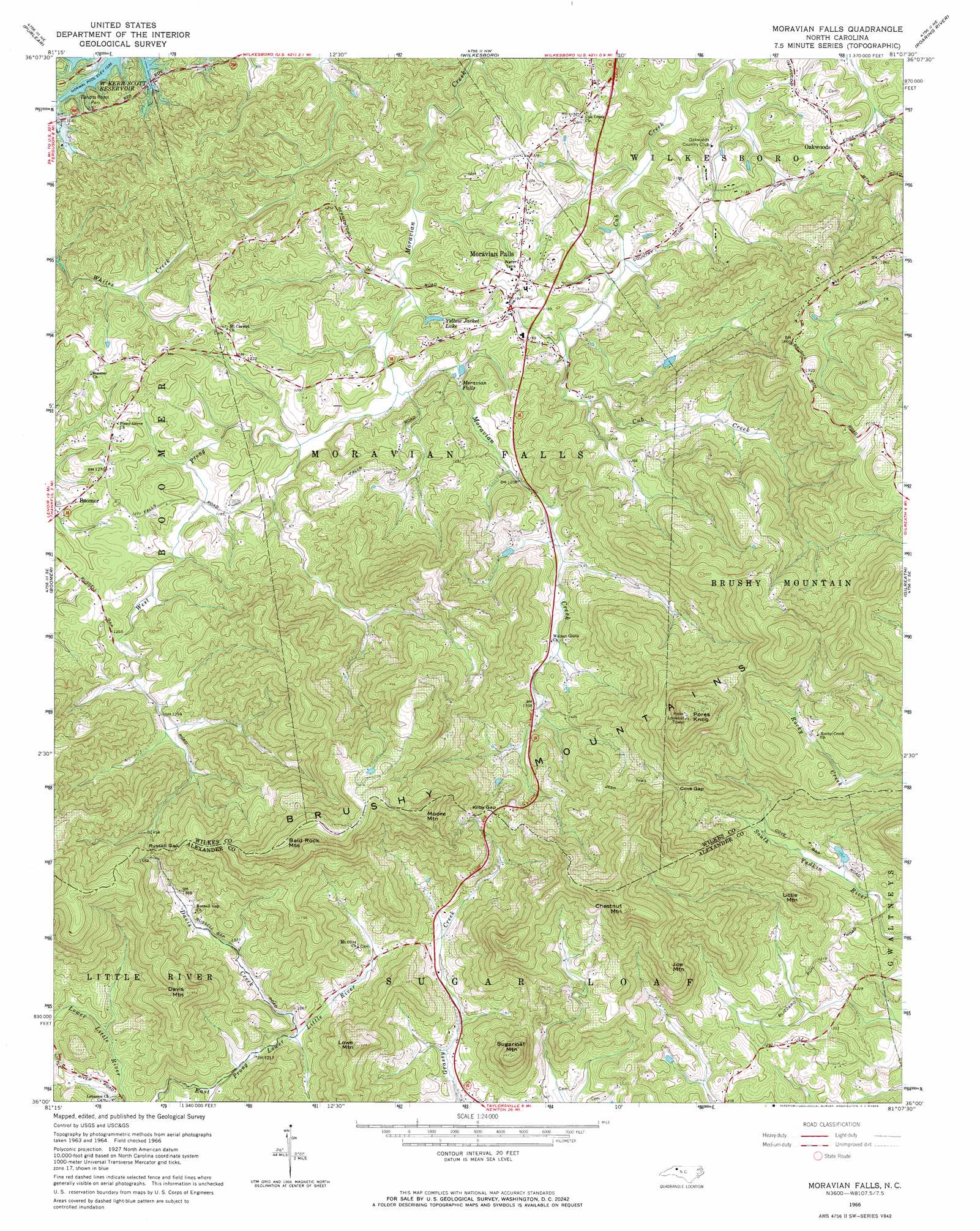
Moravian Falls Topo Map North Carolina
To zoom in, hover over the map of Moravian Falls
USGS Topo Quad 36081a2 - 1:24,000 scale
| Topo Map Name: | Moravian Falls |
| USGS Topo Quad ID: | 36081a2 |
| Print Size: | ca. 21 1/4" wide x 27" high |
| Southeast Coordinates: | 36° N latitude / 81.125° W longitude |
| Map Center Coordinates: | 36.0625° N latitude / 81.1875° W longitude |
| U.S. State: | NC |
| Filename: | o36081a2.jpg |
| Download Map JPG Image: | Moravian Falls topo map 1:24,000 scale |
| Map Type: | Topographic |
| Topo Series: | 7.5´ |
| Map Scale: | 1:24,000 |
| Source of Map Images: | United States Geological Survey (USGS) |
| Alternate Map Versions: |
Moravian Falls NC 1966, updated 1968 Download PDF Buy paper map Moravian Falls NC 2000, updated 2003 Download PDF Buy paper map Moravian Falls NC 2010 Download PDF Buy paper map Moravian Falls NC 2013 Download PDF Buy paper map Moravian Falls NC 2016 Download PDF Buy paper map |
1:24,000 Topo Quads surrounding Moravian Falls
Glendale Springs |
Horse Gap |
Mcgrady |
Traphill |
Thurmond |
Maple Springs |
Purlear |
Wilkesboro |
Roaring River |
Ronda |
Grandin |
Boomer |
Moravian Falls |
Gilreath |
Osbornville |
Kings Creek |
Ellendale |
Taylorsville |
Hiddenite |
Central |
Granite Falls |
Bethlehem |
Millersville |
Stony Point |
Statesville West |
> Back to 36081a1 at 1:100,000 scale
> Back to 36080a1 at 1:250,000 scale
> Back to U.S. Topo Maps home
Moravian Falls topo map: Gazetteer
Moravian Falls: Dams
Bentley Dam elevation 480m 1574′Ritchie Dam elevation 387m 1269′
Watts Dam elevation 377m 1236′
Yellow Jacket Lake Dam elevation 330m 1082′
Moravian Falls: Falls
Moravian Falls elevation 338m 1108′Moravian Falls: Gaps
Cove Gap elevation 560m 1837′Kilby Gap elevation 505m 1656′
Russell Gap elevation 491m 1610′
Moravian Falls: Parks
Bandits Roost Park elevation 329m 1079′Moravian Falls: Populated Places
Country Club Hills elevation 343m 1125′East Fruitland (historical) elevation 377m 1236′
Fox Run elevation 357m 1171′
Mayview Acres elevation 361m 1184′
Moravian Falls elevation 364m 1194′
Oakwoods elevation 360m 1181′
Quail Hollow Estates elevation 365m 1197′
Moravian Falls: Ranges
Brushy Mountains elevation 738m 2421′Moravian Falls: Reservoirs
Noname elevation 387m 1269′Noname elevation 480m 1574′
Watts Lake elevation 377m 1236′
Yellow Jacket Lake elevation 330m 1082′
Moravian Falls: Streams
Davis Creek elevation 373m 1223′West Prong Moravian Creek elevation 320m 1049′
Moravian Falls: Summits
Bald Rock Mountain elevation 743m 2437′Chestnut Mountain elevation 745m 2444′
Davis Mountain elevation 591m 1938′
Joe Mountain elevation 611m 2004′
Little Mountain elevation 541m 1774′
Lowe Mountain elevation 583m 1912′
Moore Mountain elevation 727m 2385′
Pores Knob elevation 810m 2657′
Sugarloaf Mountain elevation 601m 1971′
Moravian Falls digital topo map on disk
Buy this Moravian Falls topo map showing relief, roads, GPS coordinates and other geographical features, as a high-resolution digital map file on DVD:
Western Virginia & Southern West Virginia
Buy digital topo maps: Western Virginia & Southern West Virginia