Boomer Topo Map North Carolina
To zoom in, hover over the map of Boomer
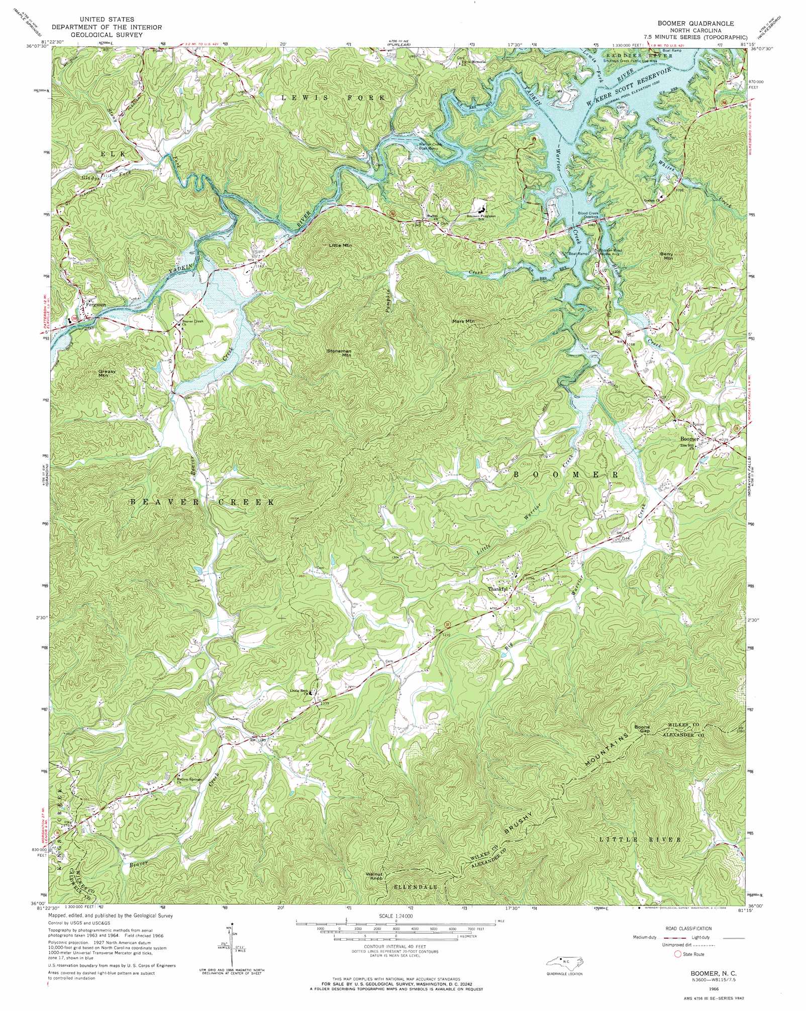
USGS Topo Quad 36081a3 - 1:24,000 scale
| Topo Map Name: | Boomer |
| USGS Topo Quad ID: | 36081a3 |
| Print Size: | ca. 21 1/4" wide x 27" high |
| Southeast Coordinates: | 36° N latitude / 81.25° W longitude |
| Map Center Coordinates: | 36.0625° N latitude / 81.3125° W longitude |
| U.S. State: | NC |
| Filename: | o36081a3.jpg |
| Download Map JPG Image: | Boomer topo map 1:24,000 scale |
| Map Type: | Topographic |
| Topo Series: | 7.5´ |
| Map Scale: | 1:24,000 |
| Source of Map Images: | United States Geological Survey (USGS) |
| Alternate Map Versions: |
Boomer NC 1966, updated 1968 Download PDF Buy paper map Boomer NC 2010 Download PDF Buy paper map Boomer NC 2013 Download PDF Buy paper map Boomer NC 2016 Download PDF Buy paper map |
1:24,000 Topo Quads surrounding Boomer
Todd |
Glendale Springs |
Horse Gap |
Mcgrady |
Traphill |
Deep Gap |
Maple Springs |
Purlear |
Wilkesboro |
Roaring River |
Buffalo Cove |
Grandin |
Boomer |
Moravian Falls |
Gilreath |
Lenoir |
Kings Creek |
Ellendale |
Taylorsville |
Hiddenite |
Drexel |
Granite Falls |
Bethlehem |
Millersville |
Stony Point |
> Back to 36081a1 at 1:100,000 scale
> Back to 36080a1 at 1:250,000 scale
> Back to U.S. Topo Maps home
Boomer topo map: Gazetteer
Boomer: Bridges
Goshen Bridge (historical) elevation 314m 1030′Boomer: Dams
Laws Pond Dam elevation 349m 1145′Walsh Fishing Lake Dam elevation 378m 1240′
Boomer: Gaps
Boone Gap elevation 592m 1942′Boomer: Parks
Boomer Road Access Area elevation 320m 1049′Boomer: Populated Places
Boomer elevation 375m 1230′Cosfort (historical) elevation 319m 1046′
Ferguson elevation 331m 1085′
Goulds (historical) elevation 337m 1105′
Oakdale elevation 355m 1164′
Thankful elevation 376m 1233′
Boomer: Reservoirs
Laws Pond elevation 349m 1145′Walsh Fishing Lake elevation 378m 1240′
Boomer: Streams
Beaver Creek elevation 320m 1049′Big Warrior Creek elevation 322m 1056′
Blood Creek elevation 313m 1026′
Gladys Fork elevation 328m 1076′
Lewis Fork elevation 313m 1026′
Little Warrior Creek elevation 322m 1056′
Pumpkin Creek elevation 313m 1026′
Stony Fork elevation 317m 1040′
Warrior Creek elevation 313m 1026′
Whites Creek elevation 313m 1026′
Boomer: Summits
Berry Mountain elevation 461m 1512′Gill Mountain elevation 443m 1453′
Greasy Mountain elevation 470m 1541′
Greasy Mountain elevation 534m 1751′
Little Mountain elevation 523m 1715′
Mars Mountain elevation 565m 1853′
McInnis Mountain elevation 458m 1502′
Smith Walker Mountain elevation 606m 1988′
Stoneman Mountain elevation 583m 1912′
Walnut Knob elevation 771m 2529′
Boomer digital topo map on disk
Buy this Boomer topo map showing relief, roads, GPS coordinates and other geographical features, as a high-resolution digital map file on DVD:
Western Virginia & Southern West Virginia
Buy digital topo maps: Western Virginia & Southern West Virginia