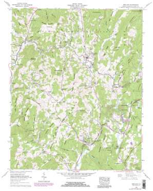
Newland Topo Map North Carolina
To zoom in, hover over the map of Newland
USGS Topo Quad 36081a8 - 1:24,000 scale
| Topo Map Name: | Newland |
| USGS Topo Quad ID: | 36081a8 |
| Print Size: | ca. 21 1/4" wide x 27" high |
| Southeast Coordinates: | 36° N latitude / 81.875° W longitude |
| Map Center Coordinates: | 36.0625° N latitude / 81.9375° W longitude |
| U.S. State: | NC |
| Filename: | o36081a8.jpg |
| Download Map JPG Image: | Newland topo map 1:24,000 scale |
| Map Type: | Topographic |
| Topo Series: | 7.5´ |
| Map Scale: | 1:24,000 |
| Source of Map Images: | United States Geological Survey (USGS) |
| Alternate Map Versions: |
Newland NC 1934 Download PDF Buy paper map Newland NC 1960, updated 1962 Download PDF Buy paper map Newland NC 1960, updated 1968 Download PDF Buy paper map Newland NC 1960, updated 1979 Download PDF Buy paper map Newland NC 1960, updated 1979 Download PDF Buy paper map Newland NW NC 1994, updated 1998 Download PDF Buy paper map Newland NC 2011 Download PDF Buy paper map Newland NC 2013 Download PDF Buy paper map Newland NC 2016 Download PDF Buy paper map |
| FStopo: | US Forest Service topo Newland is available: Download FStopo PDF Download FStopo TIF |
1:24,000 Topo Quads surrounding Newland
> Back to 36081a1 at 1:100,000 scale
> Back to 36080a1 at 1:250,000 scale
> Back to U.S. Topo Maps home
Newland topo map: Gazetteer
Newland: Cliffs
High Point Cliff elevation 1392m 4566′Newland: Dams
Land Harbors Lake Dam elevation 1073m 3520′Sloop Dam elevation 1036m 3398′
Newland: Gaps
Cow Camp Gap elevation 1233m 4045′Hartley Gap elevation 1297m 4255′
Haw Gap elevation 1183m 3881′
Loggy Gap elevation 1205m 3953′
Miller Gap elevation 1141m 3743′
Montezuma Gap elevation 1181m 3874′
Newland: Pillars
Pinnacle of the Sugar elevation 1593m 5226′Newland: Populated Places
Carpenter Bottom elevation 948m 3110′Chestnut Dale elevation 1072m 3517′
Cranberry Gap elevation 1067m 3500′
Crossnore elevation 1031m 3382′
Hughes elevation 1153m 3782′
Minneapolis elevation 971m 3185′
Montezuma elevation 1159m 3802′
Mount Pleasant elevation 1171m 3841′
Newland elevation 1101m 3612′
Pineola elevation 1082m 3549′
Pyatte elevation 1079m 3540′
Stamey Town elevation 1010m 3313′
Vale elevation 1082m 3549′
Newland: Reservoirs
Lake Kawahna elevation 1107m 3631′Land Harbors Lake elevation 1073m 3520′
Newland: Ridges
Blood Camp Ridge elevation 1274m 4179′Hartley Ridge elevation 1247m 4091′
Houston Ridge elevation 1372m 4501′
Loggy Ridge elevation 1279m 4196′
Perry Ridge elevation 1262m 4140′
Rogers Ridge elevation 1143m 3750′
Stover Ridge elevation 1190m 3904′
Newland: Streams
Anthony Creek elevation 1081m 3546′Ashley Branch elevation 1069m 3507′
Banjo Branch elevation 1064m 3490′
Big Branch elevation 1051m 3448′
Bill White Creek elevation 996m 3267′
Birchfield Creek elevation 952m 3123′
Blood Camp Branch elevation 1098m 3602′
Buckwheat Branch elevation 995m 3264′
Bunt Creek elevation 1073m 3520′
Clark Branch elevation 1012m 3320′
Cow Branch elevation 1035m 3395′
Cow Camp Creek elevation 1083m 3553′
Crossnore Creek elevation 1012m 3320′
Fall Branch elevation 986m 3234′
Fall Branch elevation 917m 3008′
Gooseneck Branch elevation 962m 3156′
Grandmother Creek elevation 1088m 3569′
Handpole Branch elevation 1096m 3595′
Haw Branch elevation 1031m 3382′
Hickorynut Branch elevation 1150m 3772′
Horse Creek elevation 969m 3179′
Isaae Branch elevation 898m 2946′
Jenny Branch elevation 1042m 3418′
Kentucky Creek elevation 1094m 3589′
Little Horse Creek elevation 982m 3221′
Little Plumtree Creek elevation 1073m 3520′
Little Whiteoak Creek elevation 1073m 3520′
Mill Timber Creek elevation 1007m 3303′
Pine Branch elevation 1000m 3280′
Row Branch elevation 1001m 3284′
Stacey Creek elevation 1061m 3480′
Trim Branch elevation 1114m 3654′
Whitaker Branch elevation 930m 3051′
White Pine Creek elevation 1026m 3366′
Whiteoak Creek elevation 1070m 3510′
Newland: Summits
Anthony Mountain elevation 1166m 3825′Belview Mountain elevation 1364m 4475′
Big Elk Mountain elevation 1342m 4402′
Big Haw Mountain elevation 1412m 4632′
Buck Hill elevation 1298m 4258′
Chestnut Mountain elevation 1216m 3989′
Cliff Hill elevation 1181m 3874′
Fork Mountain elevation 1208m 3963′
Hawshaw Mountain elevation 1298m 4258′
Little Elk Mountain elevation 1219m 3999′
Little Haw Mountain elevation 1344m 4409′
Locust Knob elevation 1151m 3776′
Marley Knob elevation 1153m 3782′
Middle Elk Mountain elevation 1200m 3937′
Moore Mountain elevation 1348m 4422′
Negro Hill elevation 1140m 3740′
Pixie Mountain elevation 1237m 4058′
Snakeden Mountain elevation 1206m 3956′
Soapstone Mountain elevation 1148m 3766′
Spanish Oak Mountain elevation 1381m 4530′
Sugar Mountain elevation 1596m 5236′
Newland: Valleys
Briggs Hollow elevation 1057m 3467′Miller Hollow elevation 1090m 3576′
Newland digital topo map on disk
Buy this Newland topo map showing relief, roads, GPS coordinates and other geographical features, as a high-resolution digital map file on DVD:
Western Virginia & Southern West Virginia
Buy digital topo maps: Western Virginia & Southern West Virginia


