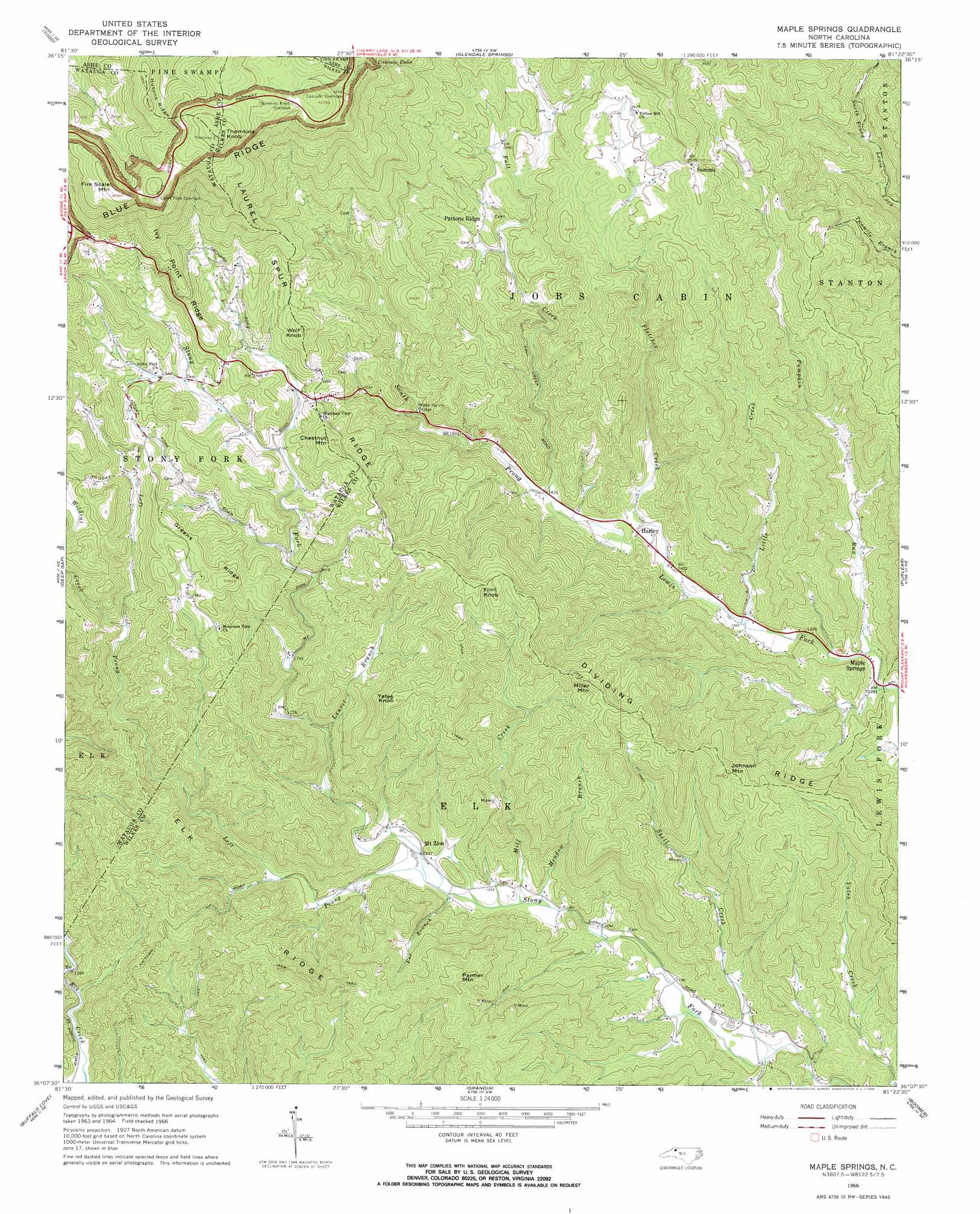
Maple Springs Topo Map North Carolina
To zoom in, hover over the map of Maple Springs
USGS Topo Quad 36081b4 - 1:24,000 scale
| Topo Map Name: | Maple Springs |
| USGS Topo Quad ID: | 36081b4 |
| Print Size: | ca. 21 1/4" wide x 27" high |
| Southeast Coordinates: | 36.125° N latitude / 81.375° W longitude |
| Map Center Coordinates: | 36.1875° N latitude / 81.4375° W longitude |
| U.S. State: | NC |
| Filename: | o36081b4.jpg |
| Download Map JPG Image: | Maple Springs topo map 1:24,000 scale |
| Map Type: | Topographic |
| Topo Series: | 7.5´ |
| Map Scale: | 1:24,000 |
| Source of Map Images: | United States Geological Survey (USGS) |
| Alternate Map Versions: |
Maple Springs NC 1966, updated 1968 Download PDF Buy paper map Maple Springs NC 1966, updated 1968 Download PDF Buy paper map Maple Springs NC 2010 Download PDF Buy paper map Maple Springs NC 2013 Download PDF Buy paper map Maple Springs NC 2016 Download PDF Buy paper map |
1:24,000 Topo Quads surrounding Maple Springs
Baldwin Gap |
Warrensville |
Jefferson |
Laurel Springs |
Whitehead |
Zionville |
Todd |
Glendale Springs |
Horse Gap |
Mcgrady |
Boone |
Deep Gap |
Maple Springs |
Purlear |
Wilkesboro |
Globe |
Buffalo Cove |
Grandin |
Boomer |
Moravian Falls |
Collettsville |
Lenoir |
Kings Creek |
Ellendale |
Taylorsville |
> Back to 36081a1 at 1:100,000 scale
> Back to 36080a1 at 1:250,000 scale
> Back to U.S. Topo Maps home
Maple Springs topo map: Gazetteer
Maple Springs: Areas
Jeffress Park elevation 1168m 3832′Maple Springs: Bridges
Wade Harris Bridge elevation 539m 1768′Maple Springs: Falls
Cascade Falls elevation 1002m 3287′Maple Springs: Populated Places
Harley elevation 436m 1430′Hendrix (historical) elevation 359m 1177′
Maple Springs elevation 392m 1286′
Mount Zion elevation 429m 1407′
Pattons Ridge elevation 626m 2053′
Stony Fork elevation 701m 2299′
Maple Springs: Ridges
Dividing Ridge elevation 723m 2372′Elk Ridge elevation 608m 1994′
Greens Ridge elevation 748m 2454′
Husons Ridge elevation 1169m 3835′
Ivy Point Ridge elevation 882m 2893′
Laurel Spur Ridge elevation 758m 2486′
Maple Springs: Streams
Fall Creek elevation 446m 1463′Fletcher Creek elevation 425m 1394′
Flowers Branch elevation 608m 1994′
Fox Branch elevation 402m 1318′
Laurel Branch elevation 493m 1617′
Left Prong Stony Fork elevation 403m 1322′
Little Creek elevation 405m 1328′
Meadow Branch elevation 393m 1289′
Mill Creek elevation 395m 1295′
Pumpkin Run elevation 391m 1282′
Shell Creek elevation 350m 1148′
Wildcat Creek elevation 589m 1932′
Maple Springs: Summits
Chestnut Mountain elevation 765m 2509′Fire Scale Mountain elevation 1172m 3845′
Flint Knob elevation 813m 2667′
Johnson Mountain elevation 736m 2414′
Miller Mountain elevation 757m 2483′
Parmer Mountain elevation 689m 2260′
Tomkins Knob elevation 1242m 4074′
Wolf Knob elevation 796m 2611′
Yates Knob elevation 747m 2450′
Maple Springs digital topo map on disk
Buy this Maple Springs topo map showing relief, roads, GPS coordinates and other geographical features, as a high-resolution digital map file on DVD:
Western Virginia & Southern West Virginia
Buy digital topo maps: Western Virginia & Southern West Virginia