Mcgrady Topo Map North Carolina
To zoom in, hover over the map of Mcgrady
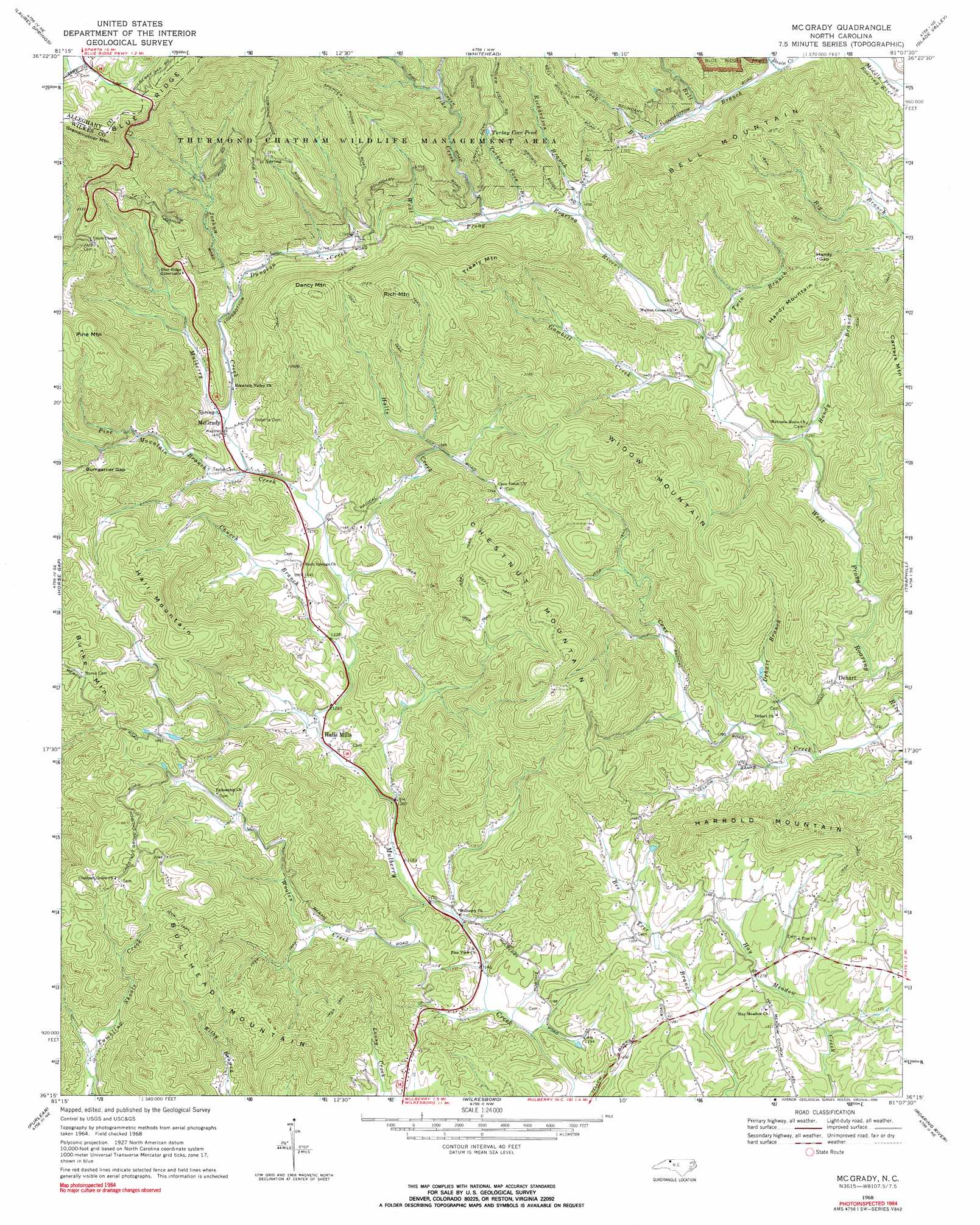
USGS Topo Quad 36081c2 - 1:24,000 scale
| Topo Map Name: | Mcgrady |
| USGS Topo Quad ID: | 36081c2 |
| Print Size: | ca. 21 1/4" wide x 27" high |
| Southeast Coordinates: | 36.25° N latitude / 81.125° W longitude |
| Map Center Coordinates: | 36.3125° N latitude / 81.1875° W longitude |
| U.S. State: | NC |
| Filename: | o36081c2.jpg |
| Download Map JPG Image: | Mcgrady topo map 1:24,000 scale |
| Map Type: | Topographic |
| Topo Series: | 7.5´ |
| Map Scale: | 1:24,000 |
| Source of Map Images: | United States Geological Survey (USGS) |
| Alternate Map Versions: |
Mc Grady NC 1968, updated 1971 Download PDF Buy paper map Mc Grady NC 1968, updated 1990 Download PDF Buy paper map McGrady NC 2010 Download PDF Buy paper map McGrady NC 2013 Download PDF Buy paper map McGrady NC 2016 Download PDF Buy paper map |
1:24,000 Topo Quads surrounding Mcgrady
Grassy Creek |
Mouth Of Wilson |
Sparta West |
Sparta East |
Cumberland Knob |
Jefferson |
Laurel Springs |
Whitehead |
Glade Valley |
Roaring Gap |
Glendale Springs |
Horse Gap |
Mcgrady |
Traphill |
Thurmond |
Maple Springs |
Purlear |
Wilkesboro |
Roaring River |
Ronda |
Grandin |
Boomer |
Moravian Falls |
Gilreath |
Osbornville |
> Back to 36081a1 at 1:100,000 scale
> Back to 36080a1 at 1:250,000 scale
> Back to U.S. Topo Maps home
Mcgrady topo map: Gazetteer
Mcgrady: Gaps
Bumgardner Gap elevation 629m 2063′Bumgarner Gap elevation 593m 1945′
Handy Gap elevation 533m 1748′
Mcgrady: Lakes
Turkey Cove Pond elevation 663m 2175′Mcgrady: Parks
Thurmond Chatham Wildlife Management Area elevation 719m 2358′Mcgrady: Populated Places
Beaux (historical) elevation 473m 1551′Dehart elevation 419m 1374′
Halls Mills elevation 376m 1233′
Hay Meadow (historical) elevation 391m 1282′
McGrady elevation 528m 1732′
Mertie (historical) elevation 597m 1958′
Newlife (historical) elevation 441m 1446′
Springfield (historical) elevation 479m 1571′
Whitty (historical) elevation 373m 1223′
Mcgrady: Streams
Bell Branch elevation 431m 1414′Church Branch elevation 392m 1286′
Cook Branch elevation 457m 1499′
Dehart Branch elevation 365m 1197′
Dungeon Creek elevation 477m 1564′
Gambill Creek elevation 407m 1335′
Halls Creek elevation 405m 1328′
Handy Branch elevation 396m 1299′
Joshua Creek elevation 443m 1453′
Noel Branch elevation 458m 1502′
Pike Creek elevation 477m 1564′
Pine Mountain Branch elevation 429m 1407′
Richardson Branch elevation 452m 1482′
Turkey Cove Branch elevation 469m 1538′
Twin Branch elevation 414m 1358′
Wooten Creek elevation 354m 1161′
Mcgrady: Summits
Bell Mountain elevation 705m 2312′Bullhead Mountain elevation 684m 2244′
Burke Mountain elevation 692m 2270′
Carters Mountain elevation 670m 2198′
Chestnut Mountain elevation 700m 2296′
Dancy Mountain elevation 736m 2414′
Grandmother Mountain elevation 1030m 3379′
Hall Mountain elevation 727m 2385′
Handy Mountain elevation 585m 1919′
Harrold Mountain elevation 529m 1735′
Pine Mountain elevation 771m 2529′
Rich Mountain elevation 763m 2503′
Trealy Mountain elevation 694m 2276′
Widow Mountain elevation 662m 2171′
Mcgrady digital topo map on disk
Buy this Mcgrady topo map showing relief, roads, GPS coordinates and other geographical features, as a high-resolution digital map file on DVD:
Western Virginia & Southern West Virginia
Buy digital topo maps: Western Virginia & Southern West Virginia