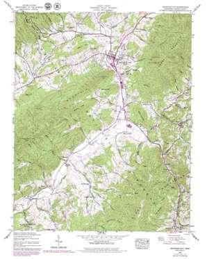
Mountain City Topo Map Tennessee
To zoom in, hover over the map of Mountain City
USGS Topo Quad 36081d7 - 1:24,000 scale
| Topo Map Name: | Mountain City |
| USGS Topo Quad ID: | 36081d7 |
| Print Size: | ca. 21 1/4" wide x 27" high |
| Southeast Coordinates: | 36.375° N latitude / 81.75° W longitude |
| Map Center Coordinates: | 36.4375° N latitude / 81.8125° W longitude |
| U.S. State: | TN |
| Filename: | o36081d7.jpg |
| Download Map JPG Image: | Mountain City topo map 1:24,000 scale |
| Map Type: | Topographic |
| Topo Series: | 7.5´ |
| Map Scale: | 1:24,000 |
| Source of Map Images: | United States Geological Survey (USGS) |
| Alternate Map Versions: |
Mountain City TN 1935 Download PDF Buy paper map Mountain City TN 1938 Download PDF Buy paper map Mountain City TN 1938, updated 1956 Download PDF Buy paper map Mountain City TN 1938, updated 1967 Download PDF Buy paper map Mountain City TN 1938, updated 1971 Download PDF Buy paper map Mountain City TN 1938, updated 1974 Download PDF Buy paper map Mountain City TN 1938, updated 1979 Download PDF Buy paper map Mountain City TN 1938, updated 1979 Download PDF Buy paper map Mountain City TN 2003, updated 2004 Download PDF Buy paper map Mountain City TN 2011 Download PDF Buy paper map Mountain City TN 2013 Download PDF Buy paper map Mountain City TN 2016 Download PDF Buy paper map |
| FStopo: | US Forest Service topo Mountain City is available: Download FStopo PDF Download FStopo TIF |
1:24,000 Topo Quads surrounding Mountain City
> Back to 36081a1 at 1:100,000 scale
> Back to 36080a1 at 1:250,000 scale
> Back to U.S. Topo Maps home
Mountain City topo map: Gazetteer
Mountain City: Airports
Johnson County Airport elevation 680m 2230′Mountain City: Mines
Butler Mine elevation 1013m 3323′Cabbage Creek Prospect elevation 874m 2867′
Flint Knob Mine elevation 929m 3047′
Gentry Mine elevation 760m 2493′
Gentry Mine elevation 855m 2805′
Haskell Mine elevation 813m 2667′
James Branch Prospect elevation 902m 2959′
Little Mountain Mine elevation 806m 2644′
Phillips Prospect elevation 899m 2949′
Shouns Prospect elevation 744m 2440′
Wilson Prospect elevation 802m 2631′
Yellow HIll Mine elevation 789m 2588′
Mountain City: Populated Places
Crackers Neck elevation 764m 2506′Heath elevation 751m 2463′
Holy Hill elevation 780m 2559′
Maymead elevation 676m 2217′
Midway elevation 750m 2460′
Mountain City elevation 737m 2417′
Neva elevation 661m 2168′
Sandy elevation 987m 3238′
Shouns elevation 702m 2303′
Vaughtsville (historical) elevation 675m 2214′
Walnut Grove elevation 800m 2624′
Mountain City: Post Offices
Vaughtsville Post Office (historical) elevation 676m 2217′Mountain City: Ridges
Bodane Ridge elevation 949m 3113′Chestnut Ridge elevation 927m 3041′
Rainbow Ridge elevation 989m 3244′
Turkey Knobs elevation 936m 3070′
Mountain City: Streams
Arnold Branch elevation 683m 2240′Avery Branch elevation 651m 2135′
Barry Branch elevation 759m 2490′
Bee Cove Branch elevation 747m 2450′
Big Sandy Creek elevation 731m 2398′
Boomer Branch elevation 777m 2549′
Brush Fork elevation 816m 2677′
Cabbage Creek elevation 678m 2224′
Christian Branch elevation 769m 2522′
Cold Branch elevation 770m 2526′
Corn Creek elevation 738m 2421′
Cress Branch elevation 875m 2870′
Crooked Branch elevation 732m 2401′
Dry Branch elevation 808m 2650′
E H Phillippi Branch elevation 804m 2637′
East Fork Fall Branch elevation 743m 2437′
East Fork Laurel Branch elevation 792m 2598′
East Fork Lunt Branch elevation 826m 2709′
Fall Branch elevation 764m 2506′
Fall Branch elevation 682m 2237′
Forge Creek elevation 704m 2309′
Furnace Creek elevation 838m 2749′
Furnace Creek elevation 723m 2372′
Goose Creek elevation 707m 2319′
James Branch elevation 738m 2421′
Katy Branch elevation 830m 2723′
Laurel Branch elevation 674m 2211′
Lumpkin Branch elevation 694m 2276′
Lunt Branch elevation 664m 2178′
Mains Branch elevation 779m 2555′
McEwen Branch elevation 737m 2417′
Mill Creek elevation 652m 2139′
Muddy Branch elevation 758m 2486′
Reese Branch elevation 664m 2178′
Reservoir Branch elevation 742m 2434′
Rhinestone Branch elevation 852m 2795′
Roaring Creek elevation 724m 2375′
Shaw Branch elevation 780m 2559′
Slimp Branch elevation 658m 2158′
Smith Branch elevation 765m 2509′
Steve Phillippi Branch elevation 780m 2559′
Stout Branch elevation 658m 2158′
Stout Branch elevation 757m 2483′
Town Creek elevation 689m 2260′
Vaught Branch elevation 738m 2421′
Vaught Creek elevation 674m 2211′
Wallace Branch elevation 825m 2706′
West Fork Fall Branch elevation 767m 2516′
West Fork Laurel Branch elevation 790m 2591′
West Fork Lunt Branch elevation 829m 2719′
Mountain City: Summits
Bird Knob elevation 976m 3202′Doe Mountain elevation 1163m 3815′
Forge Mountain elevation 1249m 4097′
Gentry Mountain elevation 930m 3051′
Holy Hill elevation 867m 2844′
Pine Mountain elevation 1139m 3736′
Rainbow Mountain elevation 895m 2936′
Mountain City: Valleys
Bryant Hollow elevation 816m 2677′Howard Hollow elevation 779m 2555′
Jenkins Hollow elevation 749m 2457′
Johnson Hollow elevation 745m 2444′
Johnson Hollow elevation 743m 2437′
Potter Hollow elevation 766m 2513′
Snider Hollow elevation 694m 2276′
Sweet Hollow elevation 770m 2526′
Triplett Hollow elevation 730m 2395′
Wallace Hollow elevation 883m 2896′
Welch Hollow elevation 757m 2483′
Wildcat Hollow elevation 726m 2381′
Mountain City digital topo map on disk
Buy this Mountain City topo map showing relief, roads, GPS coordinates and other geographical features, as a high-resolution digital map file on DVD:
Western Virginia & Southern West Virginia
Buy digital topo maps: Western Virginia & Southern West Virginia


