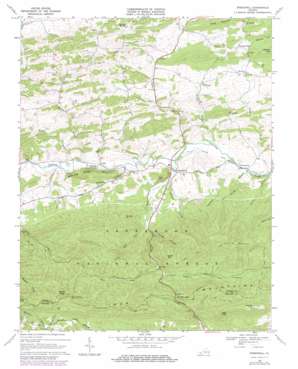
Speedwell Topo Map Virginia
To zoom in, hover over the map of Speedwell
USGS Topo Quad 36081g2 - 1:24,000 scale
| Topo Map Name: | Speedwell |
| USGS Topo Quad ID: | 36081g2 |
| Print Size: | ca. 21 1/4" wide x 27" high |
| Southeast Coordinates: | 36.75° N latitude / 81.125° W longitude |
| Map Center Coordinates: | 36.8125° N latitude / 81.1875° W longitude |
| U.S. State: | VA |
| Filename: | o36081g2.jpg |
| Download Map JPG Image: | Speedwell topo map 1:24,000 scale |
| Map Type: | Topographic |
| Topo Series: | 7.5´ |
| Map Scale: | 1:24,000 |
| Source of Map Images: | United States Geological Survey (USGS) |
| Alternate Map Versions: |
Speedwell VA 1968, updated 1971 Download PDF Buy paper map Speedwell VA 1968, updated 1979 Download PDF Buy paper map Speedwell VA 2011 Download PDF Buy paper map Speedwell VA 2013 Download PDF Buy paper map Speedwell VA 2016 Download PDF Buy paper map |
| FStopo: | US Forest Service topo Speedwell is available: Download FStopo PDF Download FStopo TIF |
1:24,000 Topo Quads surrounding Speedwell
> Back to 36081e1 at 1:100,000 scale
> Back to 36080a1 at 1:250,000 scale
> Back to U.S. Topo Maps home
Speedwell topo map: Gazetteer
Speedwell: Dams
Hungry Mother Dam elevation 753m 2470′Speedwell: Gaps
Dry Run Gap elevation 934m 3064′Speedwell: Parks
Comers Rock Recreation Area elevation 1150m 3772′Speedwell: Populated Places
Collier elevation 714m 2342′Rowe Crossroads elevation 734m 2408′
Simmerman elevation 687m 2253′
Speedwell elevation 707m 2319′
Speedwell: Springs
Wyrick Spring elevation 746m 2447′Speedwell: Streams
Big Branch elevation 707m 2319′Bowen Branch elevation 708m 2322′
Chaney Branch elevation 693m 2273′
Dry Run elevation 696m 2283′
East Dry Run Fork elevation 805m 2641′
Little Dry Run elevation 742m 2434′
Pool Spring Branch elevation 680m 2230′
Sugar Run elevation 693m 2273′
Ward Branch elevation 707m 2319′
West Dry Run Fork elevation 805m 2641′
Wolfpen Branch elevation 875m 2870′
Speedwell: Summits
Bowling Green Mountain elevation 852m 2795′Cave Hill elevation 845m 2772′
Comers Rock elevation 1237m 4058′
High Knob elevation 1150m 3772′
Horse Heaven elevation 1175m 3854′
Perkins Knob elevation 1171m 3841′
Porter Mountain elevation 1053m 3454′
Sand Mountain elevation 925m 3034′
Sindion Point elevation 920m 3018′
Speedwell: Trails
Divide Trail elevation 995m 3264′Horse Heaven Trail elevation 938m 3077′
Little Dry Run Trail elevation 842m 2762′
Perkins Knob Trail elevation 1024m 3359′
Rocky Hollow Trail elevation 808m 2650′
Speedwell: Valleys
Andrews Hollow elevation 707m 2319′Claybank Hollow elevation 701m 2299′
Henley Hollow elevation 759m 2490′
Henrey Hollow elevation 756m 2480′
Jackson Hollow elevation 706m 2316′
Laurel Hollow elevation 680m 2230′
Speedwell digital topo map on disk
Buy this Speedwell topo map showing relief, roads, GPS coordinates and other geographical features, as a high-resolution digital map file on DVD:
Western Virginia & Southern West Virginia
Buy digital topo maps: Western Virginia & Southern West Virginia


