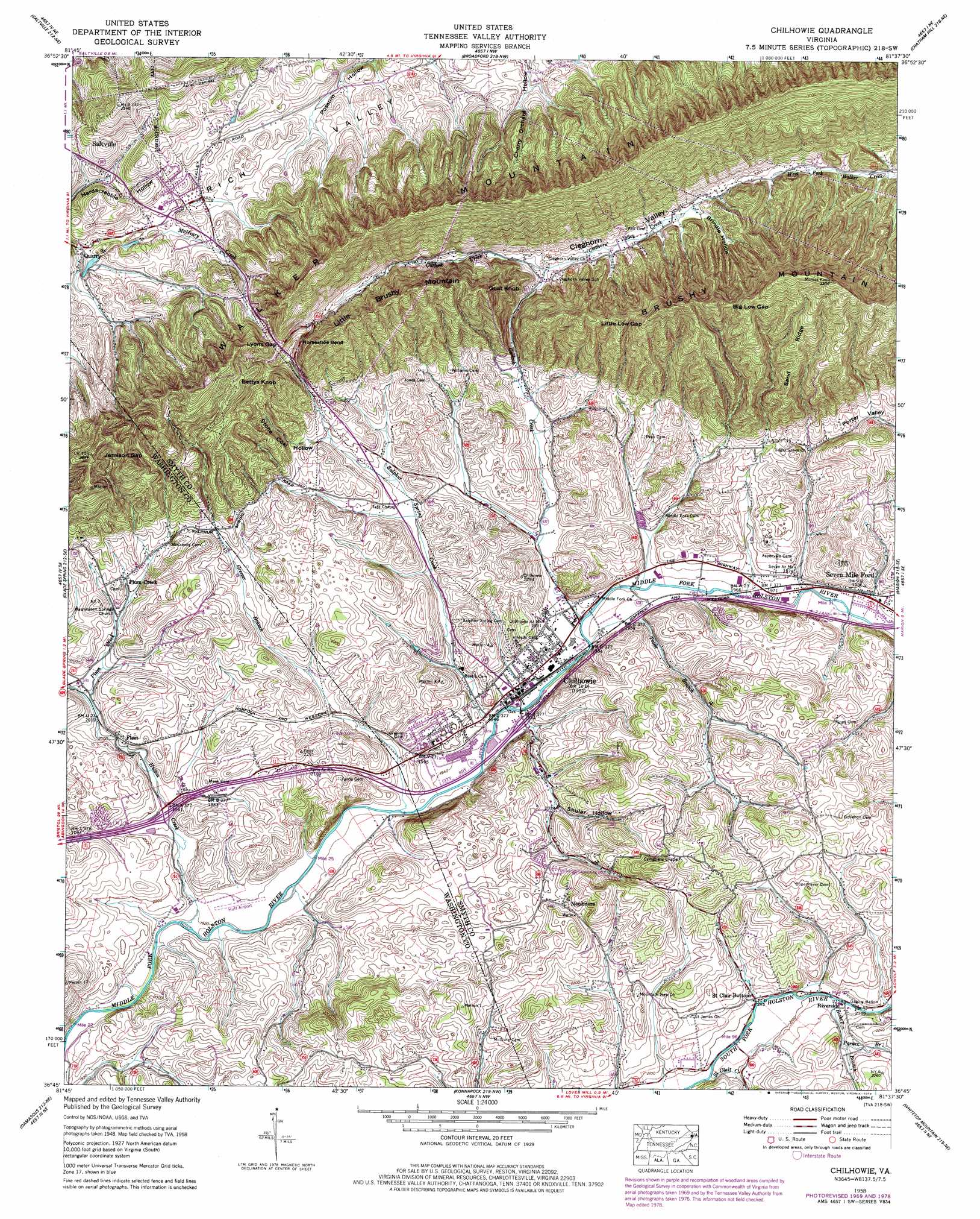
Chilhowie Topo Map Virginia
To zoom in, hover over the map of Chilhowie
USGS Topo Quad 36081g6 - 1:24,000 scale
| Topo Map Name: | Chilhowie |
| USGS Topo Quad ID: | 36081g6 |
| Print Size: | ca. 21 1/4" wide x 27" high |
| Southeast Coordinates: | 36.75° N latitude / 81.625° W longitude |
| Map Center Coordinates: | 36.8125° N latitude / 81.6875° W longitude |
| U.S. State: | VA |
| Filename: | o36081g6.jpg |
| Download Map JPG Image: | Chilhowie topo map 1:24,000 scale |
| Map Type: | Topographic |
| Topo Series: | 7.5´ |
| Map Scale: | 1:24,000 |
| Source of Map Images: | United States Geological Survey (USGS) |
| Alternate Map Versions: |
Chilhowie VA 1935 Download PDF Buy paper map Chilhowie VA 1958, updated 1960 Download PDF Buy paper map Chilhowie VA 1958, updated 1960 Download PDF Buy paper map Chilhowie VA 1958, updated 1968 Download PDF Buy paper map Chilhowie VA 1958, updated 1971 Download PDF Buy paper map Chilhowie VA 1958, updated 1978 Download PDF Buy paper map Chilhowie VA 2010 Download PDF Buy paper map Chilhowie VA 2013 Download PDF Buy paper map Chilhowie VA 2016 Download PDF Buy paper map |
| FStopo: | US Forest Service topo Chilhowie is available: Download FStopo PDF Download FStopo TIF |
1:24,000 Topo Quads surrounding Chilhowie
Honaker |
Richlands |
Pounding Mill |
Tazewell South |
Hutchinson Rock |
Elk Garden |
Saltville |
Broadford |
Chatham Hill |
Nebo |
Hayters Gap |
Glade Spring |
Chilhowie |
Marion |
Atkins |
Abingdon |
Damascus |
Konnarock |
Whitetop Mountain |
Trout Dale |
Shady Valley |
Laurel Bloomery |
Grayson |
Park |
Grassy Creek |
> Back to 36081e1 at 1:100,000 scale
> Back to 36080a1 at 1:250,000 scale
> Back to U.S. Topo Maps home
Chilhowie topo map: Gazetteer
Chilhowie: Airports
Huff Airport elevation 590m 1935′White Oak Stand Airport elevation 640m 2099′
Chilhowie: Bends
Horseshoe Bend elevation 724m 2375′Chilhowie: Bridges
Pioneer Memorial Bridge elevation 604m 1981′Chilhowie: Crossings
Interchange 32 elevation 601m 1971′Interchange 35 elevation 593m 1945′
Chilhowie: Gaps
Big Low Gap elevation 862m 2828′Jamison Gap elevation 746m 2447′
Little Low Gap elevation 838m 2749′
Lyons Gap elevation 748m 2454′
Chilhowie: Populated Places
Chilhowie elevation 595m 1952′Fleet elevation 618m 2027′
McKees Store elevation 611m 2004′
Pleasant Heights elevation 651m 2135′
Plum Creek elevation 641m 2103′
Riverside elevation 644m 2112′
Seven Mile Ford elevation 605m 1984′
Sulphur Springs Heights elevation 630m 2066′
Washington Springs elevation 690m 2263′
Chilhowie: Ridges
Sand Ridge elevation 855m 2805′Chilhowie: Streams
Bishop Branch elevation 640m 2099′Carlock Creek elevation 590m 1935′
Cleghorn Valley Creek elevation 647m 2122′
Greever Branch elevation 587m 1925′
Hutton Creek elevation 585m 1919′
Parker Branch elevation 652m 2139′
Plum Creek elevation 611m 2004′
Saint Clair Creek elevation 633m 2076′
Sulphur Spring Creek elevation 588m 1929′
Tattle Branch elevation 591m 1938′
Chilhowie: Summits
Bettys Knob elevation 827m 2713′Goat Knob elevation 855m 2805′
Little Brushy Mountain elevation 889m 2916′
Chilhowie: Valleys
Brindle Hollow elevation 669m 2194′Shular Hollow elevation 615m 2017′
Stone Coal Hollow elevation 618m 2027′
Chilhowie digital topo map on disk
Buy this Chilhowie topo map showing relief, roads, GPS coordinates and other geographical features, as a high-resolution digital map file on DVD:
Western Virginia & Southern West Virginia
Buy digital topo maps: Western Virginia & Southern West Virginia