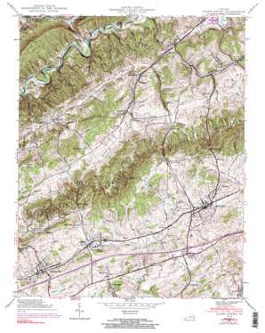
Glade Spring Topo Map Virginia
To zoom in, hover over the map of Glade Spring
USGS Topo Quad 36081g7 - 1:24,000 scale
| Topo Map Name: | Glade Spring |
| USGS Topo Quad ID: | 36081g7 |
| Print Size: | ca. 21 1/4" wide x 27" high |
| Southeast Coordinates: | 36.75° N latitude / 81.75° W longitude |
| Map Center Coordinates: | 36.8125° N latitude / 81.8125° W longitude |
| U.S. State: | VA |
| Filename: | o36081g7.jpg |
| Download Map JPG Image: | Glade Spring topo map 1:24,000 scale |
| Map Type: | Topographic |
| Topo Series: | 7.5´ |
| Map Scale: | 1:24,000 |
| Source of Map Images: | United States Geological Survey (USGS) |
| Alternate Map Versions: |
Glade Spring VA 1935 Download PDF Buy paper map Glade Spring VA 1938, updated 1958 Download PDF Buy paper map Glade Spring VA 1938, updated 1965 Download PDF Buy paper map Glade Spring VA 1938, updated 1970 Download PDF Buy paper map Glade Spring VA 1938, updated 1991 Download PDF Buy paper map Glade Spring VA 1938, updated 1991 Download PDF Buy paper map Glade Spring VA 1939 Download PDF Buy paper map Glade Spring VA 1939 Download PDF Buy paper map Glade Spring VA 2011 Download PDF Buy paper map Glade Spring VA 2013 Download PDF Buy paper map Glade Spring VA 2016 Download PDF Buy paper map |
| FStopo: | US Forest Service topo Glade Spring is available: Download FStopo PDF Download FStopo TIF |
1:24,000 Topo Quads surrounding Glade Spring
> Back to 36081e1 at 1:100,000 scale
> Back to 36080a1 at 1:250,000 scale
> Back to U.S. Topo Maps home
Glade Spring topo map: Gazetteer
Glade Spring: Bridges
Price Bridge elevation 584m 1916′Glade Spring: Crossings
Interchange 24 elevation 650m 2132′Interchange 26 elevation 659m 2162′
Interchange 29 elevation 640m 2099′
Glade Spring: Gaps
McCall Gap elevation 670m 2198′Smyth Gap elevation 690m 2263′
Glade Spring: Parks
DeVault Field elevation 638m 2093′Fullerton Field elevation 640m 2099′
Glade Spring: Populated Places
Blacksburg elevation 645m 2116′Blackwell elevation 548m 1797′
Clarksville elevation 662m 2171′
Clinchburg elevation 617m 2024′
Emory elevation 648m 2125′
Glade Spring elevation 636m 2086′
Hanckel elevation 606m 1988′
Henderson elevation 563m 1847′
Keywood elevation 633m 2076′
Litz elevation 668m 2191′
McCall Gap elevation 650m 2132′
Meadowview elevation 644m 2112′
Old Glade Spring elevation 634m 2080′
Plasterco elevation 557m 1827′
Price Hill elevation 654m 2145′
Tumbling Creek elevation 530m 1738′
Glade Spring: Post Offices
Plasterco Post Office (historical) elevation 552m 1811′Glade Spring: Ridges
Kelly Ridge elevation 735m 2411′Glade Spring: Streams
Big Creek elevation 479m 1571′Blackwell Branch elevation 533m 1748′
Count Branch elevation 529m 1735′
Double Spring Branch elevation 534m 1751′
East Fork Hall Creek elevation 628m 2060′
Keywood Branch elevation 553m 1814′
McHenry Creek elevation 503m 1650′
Moore Branch elevation 547m 1794′
Richardson Branch elevation 621m 2037′
South Fork McHenry Creek elevation 579m 1899′
Stonemill Creek elevation 501m 1643′
Tumbling Creek elevation 495m 1624′
Woodward Cove Branch elevation 539m 1768′
Glade Spring: Summits
Bald Knob elevation 773m 2536′Hall Knob elevation 794m 2604′
Glade Spring: Valleys
Collins Hollow elevation 625m 2050′Hanger Hollow elevation 631m 2070′
Hardscrabble Hollow elevation 589m 1932′
Keywood Hollow elevation 553m 1814′
Muddy Hollow elevation 509m 1669′
Patrick Hollow elevation 487m 1597′
Glade Spring digital topo map on disk
Buy this Glade Spring topo map showing relief, roads, GPS coordinates and other geographical features, as a high-resolution digital map file on DVD:
Western Virginia & Southern West Virginia
Buy digital topo maps: Western Virginia & Southern West Virginia


