White Rocks Mountain Topo Map Tennessee
To zoom in, hover over the map of White Rocks Mountain
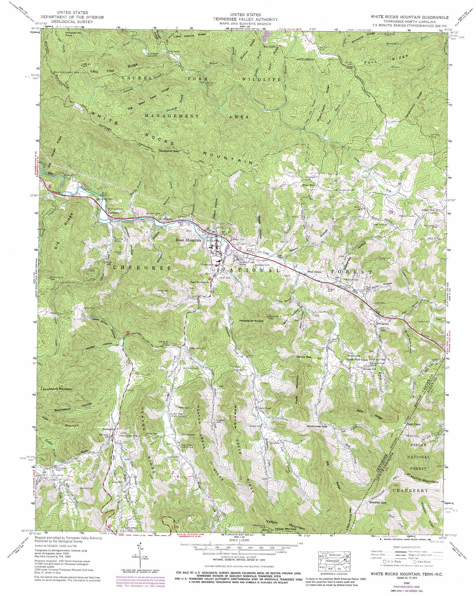
USGS Topo Quad 36082b1 - 1:24,000 scale
| Topo Map Name: | White Rocks Mountain |
| USGS Topo Quad ID: | 36082b1 |
| Print Size: | ca. 21 1/4" wide x 27" high |
| Southeast Coordinates: | 36.125° N latitude / 82° W longitude |
| Map Center Coordinates: | 36.1875° N latitude / 82.0625° W longitude |
| U.S. States: | TN, NC |
| Filename: | o36082b1.jpg |
| Download Map JPG Image: | White Rocks Mountain topo map 1:24,000 scale |
| Map Type: | Topographic |
| Topo Series: | 7.5´ |
| Map Scale: | 1:24,000 |
| Source of Map Images: | United States Geological Survey (USGS) |
| Alternate Map Versions: |
White Rocks Mtn TN 1934 Download PDF Buy paper map White Rocks Mountain TN 1960, updated 1962 Download PDF Buy paper map White Rocks Mountain TN 1960, updated 1970 Download PDF Buy paper map White Rocks Mountain TN 1960, updated 1988 Download PDF Buy paper map White Rocks Mountain TN 1994, updated 1998 Download PDF Buy paper map White Rocks Mountain TN 2003, updated 2004 Download PDF Buy paper map White Rocks Mountain TN 2011 Download PDF Buy paper map White Rocks Mountain TN 2013 Download PDF Buy paper map White Rocks Mountain TN 2016 Download PDF Buy paper map |
| FStopo: | US Forest Service topo White Rocks Mountain is available: Download FStopo PDF Download FStopo TIF |
1:24,000 Topo Quads surrounding White Rocks Mountain
Bluff City |
Keenburg |
Carter |
Doe |
Mountain City |
Johnson City |
Elizabethton |
Watauga Dam |
Elk Mills |
Sherwood |
Unicoi |
Iron Mountain Gap |
White Rocks Mountain |
Elk Park |
Valle Crucis |
Huntdale |
Bakersville |
Carvers Gap |
Newland |
Grandfather Mountain |
Burnsville |
Micaville |
Spruce Pine |
Linville Falls |
Chestnut Mountain |
> Back to 36082a1 at 1:100,000 scale
> Back to 36082a1 at 1:250,000 scale
> Back to U.S. Topo Maps home
White Rocks Mountain topo map: Gazetteer
White Rocks Mountain: Dams
Odom Trout Lake Dam elevation 1056m 3464′White Rocks Mountain: Flats
Doll Flats elevation 1392m 4566′Doll Flats elevation 1370m 4494′
Frog Level elevation 872m 2860′
White Rocks Mountain: Gaps
Bradley Gap elevation 1516m 4973′McKinney Gap elevation 1098m 3602′
Moreland Gap elevation 1161m 3809′
Vance Gap elevation 983m 3225′
Yellow Mountain Gap elevation 1435m 4708′
Yellow Mountain Gap elevation 1417m 4648′
White Rocks Mountain: Parks
Laurel Fork Wildlife Management Area elevation 936m 3070′White Rocks Mountain: Populated Places
Bitter End elevation 1053m 3454′Burbank elevation 911m 2988′
Cove Creek elevation 989m 3244′
Crabtree elevation 769m 2522′
Evergreen elevation 846m 2775′
Heaton Creek elevation 869m 2851′
Laban (historical) elevation 1045m 3428′
Laurel Fork elevation 1053m 3454′
Morgan Branch elevation 953m 3126′
Odemville (historical) elevation 1072m 3517′
Roan Mountain elevation 786m 2578′
Shell Creek elevation 809m 2654′
Squawberry elevation 1061m 3480′
Sugar Hollow elevation 850m 2788′
Upper Shell Creek elevation 950m 3116′
White Rocks Mountain: Post Offices
Roan Mountain Post Office elevation 785m 2575′White Rocks Mountain: Reservoirs
Odom Trout Lake elevation 1056m 3464′White Rocks Mountain: Ridges
Bear Ridge elevation 1294m 4245′Big Bear Cove Ridge elevation 1138m 3733′
Big Nance Ridge elevation 1021m 3349′
Big Ridge elevation 1402m 4599′
Big Ridge elevation 999m 3277′
Cherry Flats Ridge elevation 1045m 3428′
Cook Ridge elevation 1083m 3553′
Fork Ridge elevation 1004m 3293′
Hampton Creek Ridge elevation 1120m 3674′
Heaton Creek Ridge elevation 1105m 3625′
Heaton Ridge elevation 1365m 4478′
Heaton Ridge elevation 1085m 3559′
Lacy Trap Ridge elevation 1076m 3530′
Pine Mountain elevation 1123m 3684′
Vanderpool Ridge elevation 1052m 3451′
Whiteoak Ridge elevation 998m 3274′
White Rocks Mountain: Streams
Bear Branch elevation 859m 2818′Bearwallow Branch elevation 762m 2500′
Bowling Branch elevation 766m 2513′
Buck Creek elevation 784m 2572′
Bunton Branch elevation 955m 3133′
Bunton Branch elevation 956m 3136′
Camp Ten Branch elevation 975m 3198′
Cook Branch elevation 1074m 3523′
Cook Branch elevation 964m 3162′
Cove Creek elevation 989m 3244′
Cove Creek elevation 1010m 3313′
Doll Branch elevation 1072m 3517′
Duck Branch elevation 1003m 3290′
Firescald Branch elevation 909m 2982′
Firescald Branch elevation 902m 2959′
Five Poplar Branch elevation 912m 2992′
Five Poplar Branch elevation 918m 3011′
George Creek elevation 767m 2516′
George Creek elevation 762m 2500′
Hampton Creek elevation 789m 2588′
Hays Branch elevation 984m 3228′
Heaton Creek elevation 825m 2706′
Heaton Creek elevation 824m 2703′
Lacy Trap Branch elevation 861m 2824′
Laurel Branch elevation 799m 2621′
Left Prong Hampton Creek elevation 913m 2995′
Leonard Branch elevation 874m 2867′
Little Cove Creek elevation 1001m 3284′
Little Cove Creek elevation 1004m 3293′
Little Laurel Fork elevation 875m 2870′
Little Roaring Creek elevation 764m 2506′
Little Roaring Creek elevation 762m 2500′
Middle Branch elevation 931m 3054′
Middle Branch elevation 931m 3054′
Moreland Branch elevation 769m 2522′
Moreland Branch elevation 907m 2975′
Morgan Branch elevation 840m 2755′
Morgan Branch elevation 791m 2595′
Panther Branch elevation 999m 3277′
Panther Branch elevation 977m 3205′
Roaring Creek elevation 747m 2450′
Roaring Creek elevation 766m 2513′
Shell Creek elevation 802m 2631′
Shoemaker Branch elevation 777m 2549′
Sugar Hollow Creek elevation 821m 2693′
Toms Branch elevation 913m 2995′
Toms Branch elevation 919m 3015′
Wagner Branch elevation 883m 2896′
Wagner Branch elevation 888m 2913′
White Rocks Mountain: Summits
Campbell Pen Knob elevation 1068m 3503′Heupscup Knobs elevation 1059m 3474′
Hump Mountain elevation 1688m 5538′
Little Hump Mountain elevation 1587m 5206′
Pine Mountain elevation 1182m 3877′
Piney Mountain elevation 1192m 3910′
White Rocks Mountain elevation 1295m 4248′
White Rocks Mountain: Trails
Laurel Fork Trail elevation 911m 2988′Laurel Fork Trail elevation 995m 3264′
White Rocks Mountain: Valleys
Bearwallow Hollow elevation 887m 2910′Bluegrass Hollow elevation 816m 2677′
Dave Miller Hollow elevation 869m 2851′
Depot Hollow elevation 788m 2585′
Dolan Hollow elevation 827m 2713′
Ellis Hollow elevation 861m 2824′
Elm Hollow elevation 925m 3034′
Harris Hollow elevation 802m 2631′
Harrison Street Hollow elevation 790m 2591′
Hodge Hollow elevation 866m 2841′
Johnson Hollow elevation 774m 2539′
Miller Hollow elevation 913m 2995′
Mine Hollow elevation 866m 2841′
Morgan Hollow elevation 779m 2555′
Perkins Hollow elevation 894m 2933′
Perry Branch elevation 844m 2769′
Shelly Hollow elevation 783m 2568′
Webb Hollow elevation 791m 2595′
Wilder Mine Hollow elevation 877m 2877′
Winter Hollow elevation 962m 3156′
White Rocks Mountain digital topo map on disk
Buy this White Rocks Mountain topo map showing relief, roads, GPS coordinates and other geographical features, as a high-resolution digital map file on DVD:
Western Virginia & Southern West Virginia
Buy digital topo maps: Western Virginia & Southern West Virginia