Chuckey Topo Map Tennessee
To zoom in, hover over the map of Chuckey
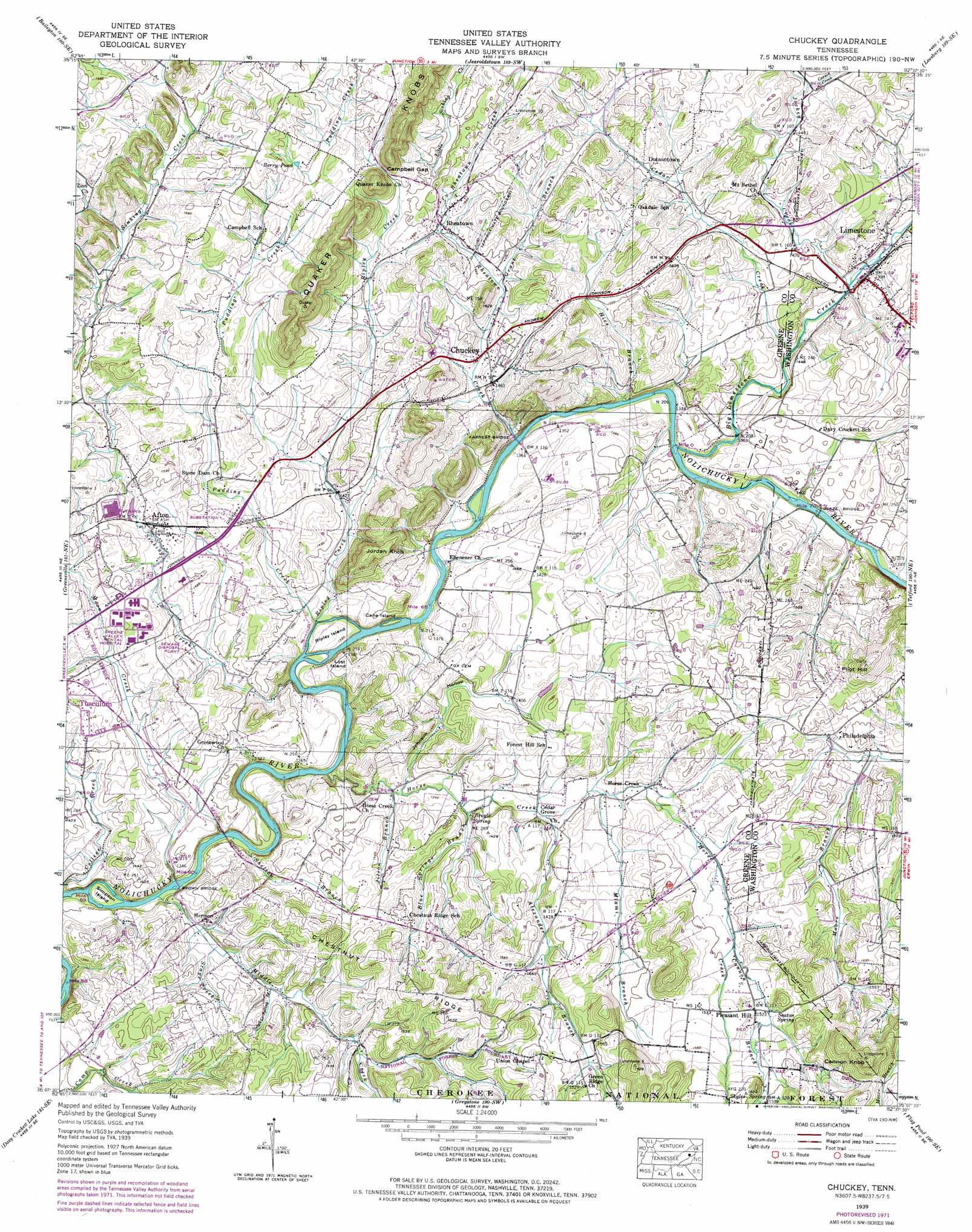
USGS Topo Quad 36082b6 - 1:24,000 scale
| Topo Map Name: | Chuckey |
| USGS Topo Quad ID: | 36082b6 |
| Print Size: | ca. 21 1/4" wide x 27" high |
| Southeast Coordinates: | 36.125° N latitude / 82.625° W longitude |
| Map Center Coordinates: | 36.1875° N latitude / 82.6875° W longitude |
| U.S. State: | TN |
| Filename: | o36082b6.jpg |
| Download Map JPG Image: | Chuckey topo map 1:24,000 scale |
| Map Type: | Topographic |
| Topo Series: | 7.5´ |
| Map Scale: | 1:24,000 |
| Source of Map Images: | United States Geological Survey (USGS) |
| Alternate Map Versions: |
Chuckey TN 1936 Download PDF Buy paper map Chuckey TN 1939 Download PDF Buy paper map Chuckey TN 1939, updated 1956 Download PDF Buy paper map Chuckey TN 1939, updated 1973 Download PDF Buy paper map Chuckey TN 2003, updated 2004 Download PDF Buy paper map Chuckey TN 2011 Download PDF Buy paper map Chuckey TN 2013 Download PDF Buy paper map Chuckey TN 2016 Download PDF Buy paper map |
| FStopo: | US Forest Service topo Chuckey is available: Download FStopo PDF Download FStopo TIF |
1:24,000 Topo Quads surrounding Chuckey
Burem |
Stony Point |
Lovelace |
Sullivan Gardens |
Boone Dam |
Mccloud |
Baileyton |
Jearoldstown |
Leesburg |
Jonesboro |
Mosheim |
Greeneville |
Chuckey |
Telford |
Erwin |
Cedar Creek |
Davy Crockett Lake |
Greystone |
Flag Pond |
Chestoa |
Paint Rock |
Hot Springs |
White Rock |
Sams Gap |
Bald Creek |
> Back to 36082a1 at 1:100,000 scale
> Back to 36082a1 at 1:250,000 scale
> Back to U.S. Topo Maps home
Chuckey topo map: Gazetteer
Chuckey: Bars
Blaines Shoals elevation 408m 1338′F Earnests Shoals elevation 397m 1302′
Gillespies Shoals elevation 405m 1328′
H Earnests Shoals elevation 402m 1318′
Howard Shoals elevation 394m 1292′
L Earnests Shoals elevation 399m 1309′
Sinking Creek Shoals elevation 394m 1292′
Chuckey: Bridges
Brown Bridge elevation 387m 1269′Earnest Bridge elevation 401m 1315′
Glaze Bridge elevation 411m 1348′
Chuckey: Gaps
Campbell Gap elevation 492m 1614′Chuckey: Islands
Cane Island elevation 396m 1299′Lost Island elevation 396m 1299′
Ripley Island elevation 407m 1335′
Simpson Island elevation 390m 1279′
Chuckey: Lakes
Berry Pond elevation 509m 1669′Chuckey: Populated Places
Afton elevation 446m 1463′Chestnut Ridge elevation 450m 1476′
Chuckey elevation 438m 1437′
Dotsontown elevation 455m 1492′
Henshaw (historical) elevation 400m 1312′
Horse Creek elevation 422m 1384′
Limestone elevation 423m 1387′
Parkland Acres elevation 441m 1446′
Philadelphia elevation 443m 1453′
Pleasant Hill elevation 471m 1545′
Pleasant View elevation 447m 1466′
Rheatown elevation 464m 1522′
Statemount (historical) elevation 488m 1601′
Chuckey: Post Offices
Afton Post Office elevation 450m 1476′Chuckey Post Office elevation 450m 1476′
Limestone Post Office elevation 421m 1381′
Chuckey: Ridges
Chestnut Ridge elevation 495m 1624′Quaker Knobs elevation 568m 1863′
Chuckey: Springs
Broyle Spring elevation 410m 1345′Horse Creek Spring elevation 425m 1394′
Seaton Spring elevation 469m 1538′
Skyles Spring elevation 487m 1597′
Chuckey: Streams
Alexander Branch elevation 411m 1348′Big Limestone Creek elevation 406m 1332′
Blue Springs Branch elevation 410m 1345′
Cannon Branch elevation 451m 1479′
Carson Creek elevation 450m 1476′
Cedar Creek elevation 414m 1358′
College Creek elevation 385m 1263′
Grant Branch elevation 444m 1456′
Hall Branch elevation 449m 1473′
Hice Branch elevation 408m 1338′
Horse Creek elevation 396m 1299′
Jilton Branch elevation 405m 1328′
Jockey Creek elevation 417m 1368′
Little Sinking Creek elevation 480m 1574′
Miami Branch elevation 420m 1377′
Middle Creek elevation 385m 1263′
Moon Creek elevation 386m 1266′
Pudding Creek elevation 404m 1325′
Rheatown Creek elevation 413m 1354′
Ripley Creek elevation 404m 1325′
Shelton Branch elevation 390m 1279′
Sinking Creek elevation 394m 1292′
Stage Creek elevation 403m 1322′
Sulphur Spring Branch elevation 411m 1348′
Chuckey: Summits
Cannon Knob elevation 597m 1958′Jordan Knob elevation 503m 1650′
Pilot Hill elevation 537m 1761′
Chuckey: Valleys
Johnson Hollow elevation 402m 1318′Chuckey digital topo map on disk
Buy this Chuckey topo map showing relief, roads, GPS coordinates and other geographical features, as a high-resolution digital map file on DVD:
Western Virginia & Southern West Virginia
Buy digital topo maps: Western Virginia & Southern West Virginia