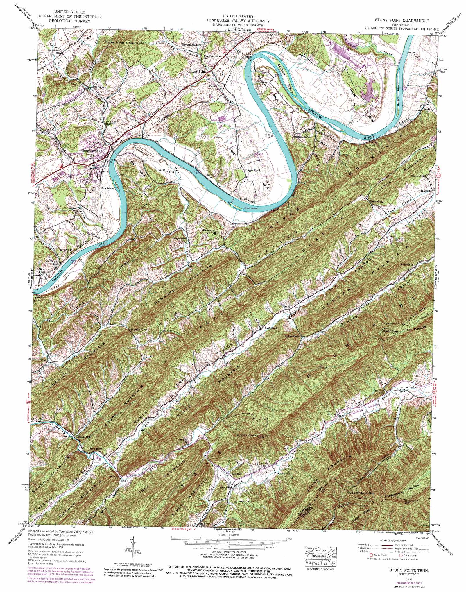
Stony Point Topo Map Tennessee
To zoom in, hover over the map of Stony Point
USGS Topo Quad 36082d7 - 1:24,000 scale
| Topo Map Name: | Stony Point |
| USGS Topo Quad ID: | 36082d7 |
| Print Size: | ca. 21 1/4" wide x 27" high |
| Southeast Coordinates: | 36.375° N latitude / 82.75° W longitude |
| Map Center Coordinates: | 36.4375° N latitude / 82.8125° W longitude |
| U.S. State: | TN |
| Filename: | o36082d7.jpg |
| Download Map JPG Image: | Stony Point topo map 1:24,000 scale |
| Map Type: | Topographic |
| Topo Series: | 7.5´ |
| Map Scale: | 1:24,000 |
| Source of Map Images: | United States Geological Survey (USGS) |
| Alternate Map Versions: |
Stonypoint TN 1935 Download PDF Buy paper map Stony Point TN 1939, updated 1954 Download PDF Buy paper map Stony Point TN 1939, updated 1972 Download PDF Buy paper map Stony Point TN 1939, updated 1988 Download PDF Buy paper map Stony Point TN 1940 Download PDF Buy paper map Stony Point TN 2010 Download PDF Buy paper map Stony Point TN 2013 Download PDF Buy paper map Stony Point TN 2016 Download PDF Buy paper map |
1:24,000 Topo Quads surrounding Stony Point
Ben Hur |
Stickleyville |
Duffield |
Clinchport |
Gate City |
Kyles Ford |
Looneys Gap |
Plum Grove |
Church Hill |
Kingsport |
Camelot |
Burem |
Stony Point |
Lovelace |
Sullivan Gardens |
Bulls Gap |
Mccloud |
Baileyton |
Jearoldstown |
Leesburg |
Mohawk |
Mosheim |
Greeneville |
Chuckey |
Telford |
> Back to 36082a1 at 1:100,000 scale
> Back to 36082a1 at 1:250,000 scale
> Back to U.S. Topo Maps home
Stony Point topo map: Gazetteer
Stony Point: Bars
Caldwells Shoals elevation 335m 1099′Christians Shoals elevation 340m 1115′
Longs Shoals elevation 335m 1099′
Stony Point: Bends
Christian Bend elevation 359m 1177′Hords Bend elevation 366m 1200′
Longs Bend elevation 375m 1230′
Phipps Bend elevation 357m 1171′
Stony Point: Cliffs
Miller Bluff elevation 337m 1105′Stony Point: Crossings
Britton Ferry (historical) elevation 333m 1092′Christians Ford elevation 337m 1105′
Lyons Ford elevation 335m 1099′
Stony Point: Dams
Greenland Park Dam elevation 348m 1141′Waste Lagoon Dam elevation 359m 1177′
Stony Point: Gaps
County Line Gap elevation 630m 2066′Jewel Gap elevation 618m 2027′
Mowls Gap elevation 376m 1233′
War Gap elevation 418m 1371′
Stony Point: Islands
Bradlys Island elevation 341m 1118′Christian Islands elevation 341m 1118′
Christians Island elevation 341m 1118′
Cox Island elevation 335m 1099′
Hords Islands elevation 341m 1118′
Miller Island elevation 337m 1105′
Stony Point: Populated Places
Blossom elevation 396m 1299′Chimneytop (historical) elevation 389m 1276′
Christian Bend elevation 366m 1200′
Kincheloe (historical) elevation 368m 1207′
Longs Bend elevation 345m 1131′
Lyons Store (historical) elevation 421m 1381′
Miller Flats elevation 341m 1118′
Mole elevation 355m 1164′
Mowls Mill elevation 348m 1141′
New Hope elevation 357m 1171′
Phipps Bend elevation 359m 1177′
Stacy elevation 371m 1217′
Stony Point elevation 362m 1187′
Surgoinsville elevation 342m 1122′
Van Hill elevation 373m 1223′
Stony Point: Reservoirs
Greenland Park Lake elevation 348m 1141′Waste Lagoon elevation 359m 1177′
Stony Point: Ridges
Grassy Mountain elevation 679m 2227′Pups Knobs elevation 403m 1322′
Stony Point: Springs
Armstrong Spring elevation 350m 1148′Ball Spring elevation 384m 1259′
Cold Spring elevation 366m 1200′
Stony Point: Streams
Big Branch elevation 389m 1276′Bradley Creek elevation 342m 1122′
Butcher Valley Creek elevation 350m 1148′
Cove Branch elevation 352m 1154′
Forgey Creek elevation 333m 1092′
Grassy Fork elevation 364m 1194′
Hunt Creek elevation 339m 1112′
North Fork Beech Creek elevation 349m 1145′
Palmer Branch elevation 347m 1138′
Patterson Branch elevation 371m 1217′
Stony Point Creek elevation 337m 1105′
Surgoinsville Creek elevation 335m 1099′
Terrill Creek elevation 335m 1099′
Washboard Creek elevation 333m 1092′
Young Branch elevation 385m 1263′
Stony Point: Summits
Alec Mountain elevation 574m 1883′Charles Mountain elevation 504m 1653′
Cove Mountain elevation 623m 2043′
Fodderstack Mountain elevation 839m 2752′
Graveyard Hill elevation 397m 1302′
Hennard Mountain elevation 506m 1660′
Little Mountain elevation 488m 1601′
McGee Mountain elevation 544m 1784′
River Mountain elevation 568m 1863′
Short Mountain elevation 567m 1860′
Stone Mountain elevation 789m 2588′
Tucker Knob elevation 461m 1512′
Stony Point: Valleys
Bear Hollow elevation 352m 1154′Beech Creek Valley elevation 371m 1217′
Bernard Hollow elevation 391m 1282′
Grassy Valley elevation 364m 1194′
Harris Hollow elevation 389m 1276′
North Fork Valley elevation 349m 1145′
War Valley elevation 383m 1256′
Widow Hollow elevation 376m 1233′
Stony Point digital topo map on disk
Buy this Stony Point topo map showing relief, roads, GPS coordinates and other geographical features, as a high-resolution digital map file on DVD:
Western Virginia & Southern West Virginia
Buy digital topo maps: Western Virginia & Southern West Virginia