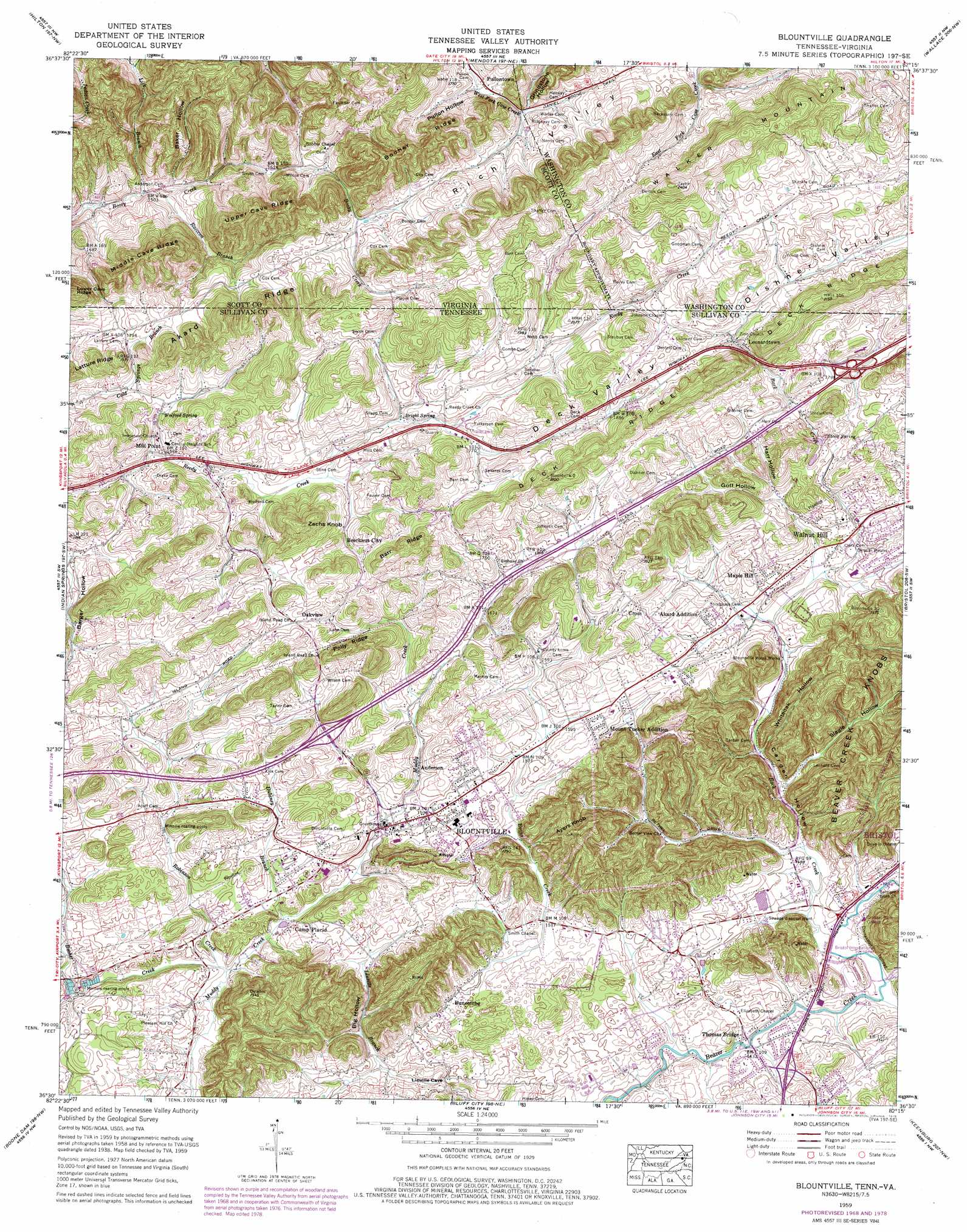
Blountville Topo Map Tennessee
To zoom in, hover over the map of Blountville
USGS Topo Quad 36082e3 - 1:24,000 scale
| Topo Map Name: | Blountville |
| USGS Topo Quad ID: | 36082e3 |
| Print Size: | ca. 21 1/4" wide x 27" high |
| Southeast Coordinates: | 36.5° N latitude / 82.25° W longitude |
| Map Center Coordinates: | 36.5625° N latitude / 82.3125° W longitude |
| U.S. States: | TN, VA |
| Filename: | o36082e3.jpg |
| Download Map JPG Image: | Blountville topo map 1:24,000 scale |
| Map Type: | Topographic |
| Topo Series: | 7.5´ |
| Map Scale: | 1:24,000 |
| Source of Map Images: | United States Geological Survey (USGS) |
| Alternate Map Versions: |
Blountville TN 1935 Download PDF Buy paper map Blountville TN 1938, updated 1954 Download PDF Buy paper map Blountville TN 1939 Download PDF Buy paper map Blountville TN 1959, updated 1962 Download PDF Buy paper map Blountville TN 1959, updated 1967 Download PDF Buy paper map Blountville TN 1959, updated 1970 Download PDF Buy paper map Blountville TN 1959, updated 1978 Download PDF Buy paper map Blountville TN 1959, updated 1978 Download PDF Buy paper map Blountville TN 2010 Download PDF Buy paper map Blountville TN 2013 Download PDF Buy paper map Blountville TN 2016 Download PDF Buy paper map |
1:24,000 Topo Quads surrounding Blountville
Fort Blackmore |
Dungannon |
Moll Creek |
Hansonville |
Brumley |
Gate City |
Hilton |
Mendota |
Wallace |
Wyndale |
Kingsport |
Indian Springs |
Blountville |
Bristol |
Holston Valley |
Sullivan Gardens |
Boone Dam |
Bluff City |
Keenburg |
Carter |
Leesburg |
Jonesboro |
Johnson City |
Elizabethton |
Watauga Dam |
> Back to 36082e1 at 1:100,000 scale
> Back to 36082a1 at 1:250,000 scale
> Back to U.S. Topo Maps home
Blountville topo map: Gazetteer
Blountville: Basins
Dishner Valley elevation 573m 1879′Blountville: Crossings
Interchange 69 elevation 505m 1656′Interchange 74 elevation 541m 1774′
Blountville: Populated Places
Akard Addition elevation 493m 1617′Anderson elevation 489m 1604′
Beechnut City elevation 519m 1702′
Blountville elevation 469m 1538′
Buncombe elevation 462m 1515′
Camp Placid elevation 457m 1499′
Cantrell (historical) elevation 461m 1512′
Cross elevation 527m 1729′
Earheart (historical) elevation 446m 1463′
Hill Country elevation 532m 1745′
Leonardtown elevation 555m 1820′
Maple Hill elevation 493m 1617′
Maplehurst elevation 480m 1574′
Mill Point elevation 486m 1594′
Mount Area Estates elevation 507m 1663′
Mount Tucker Addition elevation 507m 1663′
Oakleigh Estates elevation 513m 1683′
Oakview elevation 567m 1860′
Pullontown elevation 519m 1702′
Sac (historical) elevation 469m 1538′
Sunny Hills elevation 500m 1640′
Walnut Hill elevation 490m 1607′
Windy Hill elevation 458m 1502′
Blountville: Post Offices
Blountville Post Office elevation 471m 1545′Blountville: Ridges
Akard Ridge elevation 657m 2155′Akard Ridge elevation 581m 1906′
Barr Ridge elevation 626m 2053′
Booher Ridge elevation 671m 2201′
Deck Ridge elevation 662m 2171′
Deck Ridge elevation 664m 2178′
Latture Ridge elevation 570m 1870′
Middle Cave Ridge elevation 620m 2034′
Polly Ridge elevation 590m 1935′
Upper Cave Ridge elevation 650m 2132′
Blountville: Springs
Bright Spring elevation 535m 1755′Steele Spring elevation 517m 1696′
Wolford Spring elevation 520m 1706′
Blountville: Streams
Back Creek elevation 439m 1440′Booher Creek elevation 443m 1453′
Burr Branch elevation 434m 1423′
Dulaney Branch elevation 448m 1469′
Evans Creek elevation 458m 1502′
Lick Branch elevation 451m 1479′
Raccon Branch elevation 456m 1496′
Reedy Creek elevation 439m 1440′
Robinson Creek elevation 442m 1450′
Slagle Creek elevation 444m 1456′
Whitetop Creek elevation 433m 1420′
Blountville: Summits
Ayers Knob elevation 576m 1889′Graveyard Hill elevation 502m 1646′
Walker Mountain elevation 727m 2385′
Zachs Knob elevation 605m 1984′
Blountville: Valleys
Baker Hollow elevation 468m 1535′Barger Hollow elevation 485m 1591′
Big Hollow elevation 445m 1459′
Carden Hollow elevation 442m 1450′
Deck Valley elevation 550m 1804′
Gott Hollow elevation 494m 1620′
Grindstone Hollow elevation 528m 1732′
Harr Hollow elevation 506m 1660′
Hobbs Hollow elevation 518m 1699′
Leonard Hollow elevation 457m 1499′
McClellan Hollow elevation 442m 1450′
Pullon Hollow elevation 513m 1683′
Rich Valley elevation 565m 1853′
Rodefer Hollow elevation 531m 1742′
Ross Hollow elevation 449m 1473′
Slagle Hollow elevation 446m 1463′
Whiteoak Hollow elevation 447m 1466′
Blountville digital topo map on disk
Buy this Blountville topo map showing relief, roads, GPS coordinates and other geographical features, as a high-resolution digital map file on DVD:
Western Virginia & Southern West Virginia
Buy digital topo maps: Western Virginia & Southern West Virginia