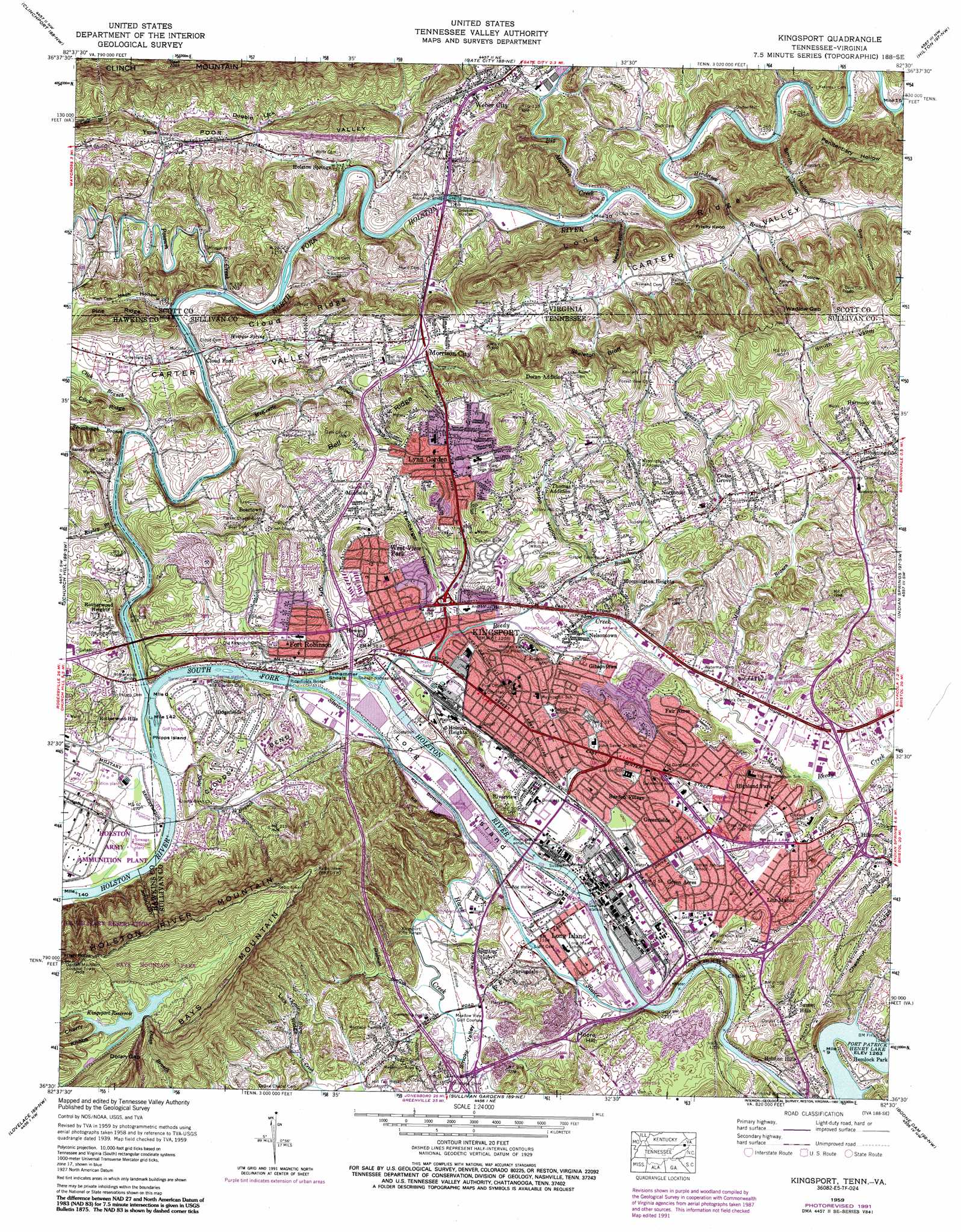
Kingsport Topo Map Tennessee
To zoom in, hover over the map of Kingsport
USGS Topo Quad 36082e5 - 1:24,000 scale
| Topo Map Name: | Kingsport |
| USGS Topo Quad ID: | 36082e5 |
| Print Size: | ca. 21 1/4" wide x 27" high |
| Southeast Coordinates: | 36.5° N latitude / 82.5° W longitude |
| Map Center Coordinates: | 36.5625° N latitude / 82.5625° W longitude |
| U.S. States: | TN, VA |
| Filename: | o36082e5.jpg |
| Download Map JPG Image: | Kingsport topo map 1:24,000 scale |
| Map Type: | Topographic |
| Topo Series: | 7.5´ |
| Map Scale: | 1:24,000 |
| Source of Map Images: | United States Geological Survey (USGS) |
| Alternate Map Versions: |
Kingsport TN 1935 Download PDF Buy paper map Kingsport TN 1939 Download PDF Buy paper map Kingsport TN 1939, updated 1956 Download PDF Buy paper map Kingsport TN 1959, updated 1960 Download PDF Buy paper map Kingsport TN 1959, updated 1967 Download PDF Buy paper map Kingsport TN 1959, updated 1970 Download PDF Buy paper map Kingsport TN 1959, updated 1978 Download PDF Buy paper map Kingsport TN 1959, updated 1988 Download PDF Buy paper map Kingsport TN 1959, updated 1992 Download PDF Buy paper map Kingsport TN 2010 Download PDF Buy paper map Kingsport TN 2013 Download PDF Buy paper map Kingsport TN 2016 Download PDF Buy paper map |
1:24,000 Topo Quads surrounding Kingsport
Big Stone Gap |
East Stone Gap |
Fort Blackmore |
Dungannon |
Moll Creek |
Duffield |
Clinchport |
Gate City |
Hilton |
Mendota |
Plum Grove |
Church Hill |
Kingsport |
Indian Springs |
Blountville |
Stony Point |
Lovelace |
Sullivan Gardens |
Boone Dam |
Bluff City |
Baileyton |
Jearoldstown |
Leesburg |
Jonesboro |
Johnson City |
> Back to 36082e1 at 1:100,000 scale
> Back to 36082a1 at 1:250,000 scale
> Back to U.S. Topo Maps home
Kingsport topo map: Gazetteer
Kingsport: Bars
Camp-meeting Creek Shoals elevation 356m 1167′Jourdens Shoals elevation 355m 1164′
North Fork Shoals elevation 351m 1151′
State Line Shoals elevation 360m 1181′
Tilthammer Shoals elevation 356m 1167′
Kingsport: Basins
Double Lick elevation 393m 1289′Kingsport: Bends
Chase Bend elevation 386m 1266′Clouds Bend elevation 400m 1312′
Kit Bottom elevation 362m 1187′
Kingsport: Bridges
John M Johnson Memorial Bridge elevation 365m 1197′Ridgefields Bridge elevation 355m 1164′
Rotherwood Bridge elevation 355m 1164′
Kingsport: Cliffs
Kit Bluff elevation 379m 1243′Skeleton Bluff elevation 434m 1423′
Kingsport: Crossings
Boones Ford elevation 371m 1217′Interchange 51 elevation 368m 1207′
Interchange 55 elevation 375m 1230′
Kingsport: Dams
Bays Mountain Dam elevation 549m 1801′Winegar Mill Dam (historical) elevation 365m 1197′
Kingsport: Falls
Monkey Falls elevation 376m 1233′Kingsport: Gaps
Dolan Gap elevation 529m 1735′Wadlow Gap elevation 466m 1528′
Wadlow Gap elevation 464m 1522′
Kingsport: Islands
Long Island elevation 361m 1184′Phipps Island elevation 353m 1158′
Wexler Islands elevation 366m 1200′
Kingsport: Parks
Anderson Block House Monument elevation 409m 1341′Bays Mountain Park elevation 595m 1952′
Centennial Boat Yard Park elevation 357m 1171′
Cloud Park elevation 360m 1181′
Eastman Recreation Area elevation 459m 1505′
J Fred Johnson Park elevation 394m 1292′
Riverfront Park elevation 364m 1194′
Kingsport: Populated Places
Amersham elevation 394m 1292′Beartown elevation 468m 1535′
Beechwood Village elevation 395m 1295′
Bloomington Heights elevation 396m 1299′
Borden Village elevation 384m 1259′
Cedar Grove elevation 421m 1381′
Cherokee Village elevation 363m 1190′
Cliffside elevation 417m 1368′
Cloud Ford elevation 360m 1181′
Darlington Heights elevation 414m 1358′
Doran Addition elevation 489m 1604′
Dorter Mill elevation 376m 1233′
East Kingsport elevation 414m 1358′
Eden Ridge (historical) elevation 401m 1315′
Fair Acres elevation 404m 1325′
Fort Robinson elevation 399m 1309′
Fox Run elevation 403m 1322′
Gibsontown elevation 374m 1227′
Green Acres elevation 388m 1272′
Greenfields elevation 386m 1266′
Greenvale elevation 391m 1282′
Harmony Hills elevation 444m 1456′
Hemlock Park elevation 394m 1292′
Hiara Heights elevation 383m 1256′
Highland Park elevation 400m 1312′
Holston Heights elevation 409m 1341′
Holston Hills elevation 406m 1332′
Horace (historical) elevation 369m 1210′
Howard Hill elevation 387m 1269′
Huntington Hills elevation 392m 1286′
Kingsport elevation 369m 1210′
Larkspur elevation 477m 1564′
Litz Manor elevation 408m 1338′
Long Island elevation 362m 1187′
Lynn Garden elevation 437m 1433′
Midfields elevation 434m 1423′
Morrison City elevation 395m 1295′
Nelsontown elevation 365m 1197′
Northcott elevation 432m 1417′
Petlier (historical) elevation 362m 1187′
Preston Forest elevation 392m 1286′
Ridgefields elevation 389m 1276′
Riverview elevation 371m 1217′
Rotherwood elevation 368m 1207′
Rotherwood Heights elevation 423m 1387′
Rotherwood Hills elevation 385m 1263′
Sevier Terrace elevation 409m 1341′
Skyview Estates elevation 468m 1535′
Springdale elevation 378m 1240′
Sunset Hills elevation 409m 1341′
Thomas Addition elevation 431m 1414′
Weber City elevation 398m 1305′
West View Park elevation 416m 1364′
Windmere elevation 423m 1387′
Winegar Mill elevation 376m 1233′
Yuma elevation 394m 1292′
Kingsport: Post Offices
Kingsport Post Office elevation 369m 1210′Lynn Garden Post Office elevation 436m 1430′
Kingsport: Reservoirs
Bays Mountain Reservoir elevation 549m 1801′Kingsport Reservoir elevation 553m 1814′
Kingsport: Ridges
Bell Ridge elevation 436m 1430′Cloud Ridge elevation 493m 1617′
Cloud Ridge elevation 438m 1437′
Lick Ridge elevation 408m 1338′
Long Ridge elevation 502m 1646′
Pine Ridge elevation 496m 1627′
Pine Ridge elevation 488m 1601′
Proposal Ridge elevation 664m 2178′
Kingsport: Springs
Holston Springs elevation 367m 1204′Winegar Spring elevation 377m 1236′
Kingsport: Streams
Anderson Branch elevation 372m 1220′Big Moccasin Creek elevation 366m 1200′
Camp-meeting Creek elevation 359m 1177′
Click Branch elevation 356m 1167′
Gravelly Branch elevation 360m 1181′
Henderson Branch elevation 368m 1207′
Horse Creek elevation 361m 1184′
Little Horse Creek elevation 371m 1217′
McKenzie Branch elevation 356m 1167′
Miller Branch elevation 364m 1194′
North Fork Holston River elevation 354m 1161′
North Fork Holston River elevation 354m 1161′
Possum Creek elevation 367m 1204′
Possum Creek elevation 367m 1204′
Reedy Creek elevation 356m 1167′
Ripley Branch elevation 359m 1177′
Roach Branch elevation 407m 1335′
Rock Springs Branch elevation 364m 1194′
Rocksprings Branch elevation 362m 1187′
Sensabaugh Branch elevation 355m 1164′
Slate Branch elevation 354m 1161′
South Fork Holston River elevation 353m 1158′
Stidman Branch elevation 365m 1197′
Wininger Spring Branch elevation 358m 1174′
Kingsport: Summits
Bald Knob elevation 553m 1814′Frisby Knob elevation 524m 1719′
High Point elevation 726m 2381′
Moore Hill elevation 435m 1427′
Walker Mountain elevation 559m 1833′
Kingsport: Tunnels
Sensabaugh Tunnel elevation 395m 1295′Kingsport: Valleys
Buckles Hollow elevation 419m 1374′Carter Valley elevation 399m 1309′
Dry Hollow elevation 365m 1197′
Gooseneck Hollow elevation 406m 1332′
Guy Hollow elevation 415m 1361′
Hush Hollow elevation 366m 1200′
Newland Hollow elevation 375m 1230′
Penitentiary Hollow elevation 384m 1259′
Shipp Hollow elevation 379m 1243′
Smith Hollow elevation 371m 1217′
Smith Valley elevation 456m 1496′
Smoky Valley elevation 361m 1184′
Tranbarger Hollow elevation 365m 1197′
Kingsport digital topo map on disk
Buy this Kingsport topo map showing relief, roads, GPS coordinates and other geographical features, as a high-resolution digital map file on DVD:
Western Virginia & Southern West Virginia
Buy digital topo maps: Western Virginia & Southern West Virginia