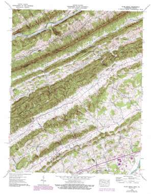
Plum Grove Topo Map Tennessee
To zoom in, hover over the map of Plum Grove
USGS Topo Quad 36082e7 - 1:24,000 scale
| Topo Map Name: | Plum Grove |
| USGS Topo Quad ID: | 36082e7 |
| Print Size: | ca. 21 1/4" wide x 27" high |
| Southeast Coordinates: | 36.5° N latitude / 82.75° W longitude |
| Map Center Coordinates: | 36.5625° N latitude / 82.8125° W longitude |
| U.S. States: | TN, VA |
| Filename: | o36082e7.jpg |
| Download Map JPG Image: | Plum Grove topo map 1:24,000 scale |
| Map Type: | Topographic |
| Topo Series: | 7.5´ |
| Map Scale: | 1:24,000 |
| Source of Map Images: | United States Geological Survey (USGS) |
| Alternate Map Versions: |
Plum Grove TN 1935 Download PDF Buy paper map Plum Grove TN 1939 Download PDF Buy paper map Plum Grove TN 1939, updated 1954 Download PDF Buy paper map Plum Grove TN 1939, updated 1970 Download PDF Buy paper map Plum Grove TN 1939, updated 1978 Download PDF Buy paper map Plum Grove TN 1939, updated 1993 Download PDF Buy paper map Plum Grove TN 2010 Download PDF Buy paper map Plum Grove TN 2013 Download PDF Buy paper map Plum Grove TN 2016 Download PDF Buy paper map |
1:24,000 Topo Quads surrounding Plum Grove
> Back to 36082e1 at 1:100,000 scale
> Back to 36082a1 at 1:250,000 scale
> Back to U.S. Topo Maps home
Plum Grove topo map: Gazetteer
Plum Grove: Crossings
Hord Ford elevation 341m 1118′Plum Grove: Gaps
Collins Gap elevation 511m 1676′Fields Gap elevation 454m 1489′
Plum Grove Gap elevation 441m 1446′
Powers Gap elevation 423m 1387′
Plum Grove: Pillars
Big Rock elevation 693m 2273′Plum Grove: Populated Places
Bellamytown elevation 421m 1381′Cold Springs elevation 448m 1469′
Flat Rock elevation 368m 1207′
Greenland elevation 366m 1200′
Midway elevation 444m 1456′
New Canton elevation 388m 1272′
Okolona elevation 450m 1476′
Opossum (historical) elevation 450m 1476′
Starnes (historical) elevation 436m 1430′
Plum Grove: Ridges
Copper Ridge elevation 594m 1948′Possum Knobs elevation 585m 1919′
Plum Grove: Streams
Caney Valley Branch elevation 445m 1459′Collins Branch elevation 433m 1420′
Frozen Branch elevation 443m 1453′
Head Creek elevation 363m 1190′
Lick Branch elevation 453m 1486′
McClure Branch elevation 364m 1194′
Poor Valley Branch elevation 437m 1433′
Powers Branch elevation 364m 1194′
Renfroe Creek elevation 358m 1174′
Right Prong Caney Creek elevation 451m 1479′
Sevier Branch elevation 342m 1122′
Shelby Creek elevation 392m 1286′
Valley Branch elevation 444m 1456′
Plum Grove: Summits
Caney Knobs elevation 595m 1952′Plum Grove: Valleys
California Hollow elevation 434m 1423′Caney Valley elevation 446m 1463′
Cross Valley elevation 358m 1174′
Plum Grove digital topo map on disk
Buy this Plum Grove topo map showing relief, roads, GPS coordinates and other geographical features, as a high-resolution digital map file on DVD:
Western Virginia & Southern West Virginia
Buy digital topo maps: Western Virginia & Southern West Virginia


