Stickleyville Topo Map Virginia
To zoom in, hover over the map of Stickleyville
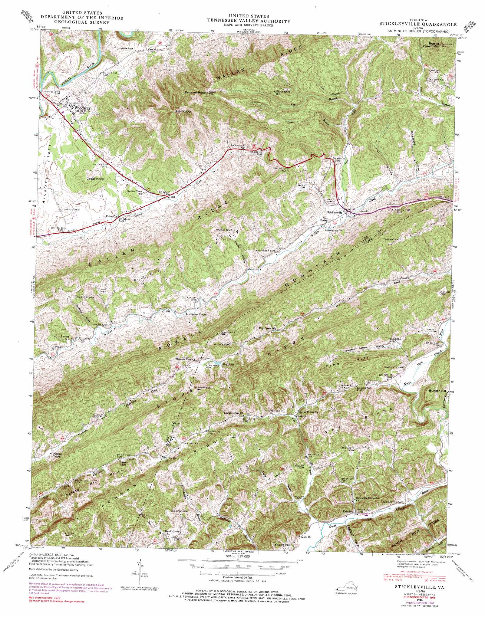
USGS Topo Quad 36082f8 - 1:24,000 scale
| Topo Map Name: | Stickleyville |
| USGS Topo Quad ID: | 36082f8 |
| Print Size: | ca. 21 1/4" wide x 27" high |
| Southeast Coordinates: | 36.625° N latitude / 82.875° W longitude |
| Map Center Coordinates: | 36.6875° N latitude / 82.9375° W longitude |
| U.S. State: | VA |
| Filename: | o36082f8.jpg |
| Download Map JPG Image: | Stickleyville topo map 1:24,000 scale |
| Map Type: | Topographic |
| Topo Series: | 7.5´ |
| Map Scale: | 1:24,000 |
| Source of Map Images: | United States Geological Survey (USGS) |
| Alternate Map Versions: |
Stickleyville VA 1935 Download PDF Buy paper map Stickleyville VA 1946, updated 1970 Download PDF Buy paper map Stickleyville VA 1946, updated 1978 Download PDF Buy paper map Stickleyville VA 1948, updated 1949 Download PDF Buy paper map Stickleyville VA 1948, updated 1949 Download PDF Buy paper map Stickleyville VA 1948, updated 1965 Download PDF Buy paper map Stickleyville VA 1976, updated 1981 Download PDF Buy paper map Stickleyville VA 2010 Download PDF Buy paper map Stickleyville VA 2013 Download PDF Buy paper map Stickleyville VA 2016 Download PDF Buy paper map |
| FStopo: | US Forest Service topo Stickleyville is available: Download FStopo PDF Download FStopo TIF |
1:24,000 Topo Quads surrounding Stickleyville
Nolansburg |
Louellen |
Benham |
Appalachia |
Norton |
Evarts |
Pennington Gap |
Keokee |
Big Stone Gap |
East Stone Gap |
Hubbard Springs |
Ben Hur |
Stickleyville |
Duffield |
Clinchport |
Sneedville |
Kyles Ford |
Looneys Gap |
Plum Grove |
Church Hill |
Lee Valley |
Camelot |
Burem |
Stony Point |
Lovelace |
> Back to 36082e1 at 1:100,000 scale
> Back to 36082a1 at 1:250,000 scale
> Back to U.S. Topo Maps home
Stickleyville topo map: Gazetteer
Stickleyville: Basins
Back Valley elevation 602m 1975′The Sinks elevation 459m 1505′
Stickleyville: Lakes
Flag Pond elevation 614m 2014′Stickleyville: Populated Places
Canton elevation 399m 1309′Fairview elevation 365m 1197′
Stickleyville elevation 497m 1630′
Woodway elevation 443m 1453′
Stickleyville: Ranges
North Fork Knobs elevation 526m 1725′Potato Hill Knobs elevation 514m 1686′
Powell Mountain elevation 762m 2500′
Stickleyville: Ridges
Stone Ridge elevation 778m 2552′Stickleyville: Springs
Blue Spring elevation 492m 1614′Stickleyville: Streams
Clark Branch elevation 550m 1804′Cox Branch elevation 578m 1896′
Dry Creek elevation 492m 1614′
England Valley Branch elevation 362m 1187′
Fox Branch elevation 582m 1909′
Lewis Branch elevation 370m 1213′
Newberry Creek elevation 460m 1509′
North Fork Powell River elevation 400m 1312′
Stickleyville: Summits
Bunker Hill elevation 527m 1729′Butt of Powell Mountain elevation 863m 2831′
Buzzard Roost elevation 972m 3188′
Cedar Knob elevation 541m 1774′
Eliza Knob elevation 806m 2644′
Elk Knob elevation 876m 2874′
Pine Hill elevation 630m 2066′
Stickleyville: Trails
Daniel Boone Trail elevation 414m 1358′Stickleyville: Valleys
England Valley elevation 364m 1194′Fallin Hollow elevation 502m 1646′
Kimberland Hollow elevation 504m 1653′
Maness Hollow elevation 379m 1243′
Rasnic Hollow elevation 473m 1551′
Renfroe Valley elevation 371m 1217′
Sulphur Spring Valley elevation 407m 1335′
Stickleyville digital topo map on disk
Buy this Stickleyville topo map showing relief, roads, GPS coordinates and other geographical features, as a high-resolution digital map file on DVD:
Western Virginia & Southern West Virginia
Buy digital topo maps: Western Virginia & Southern West Virginia