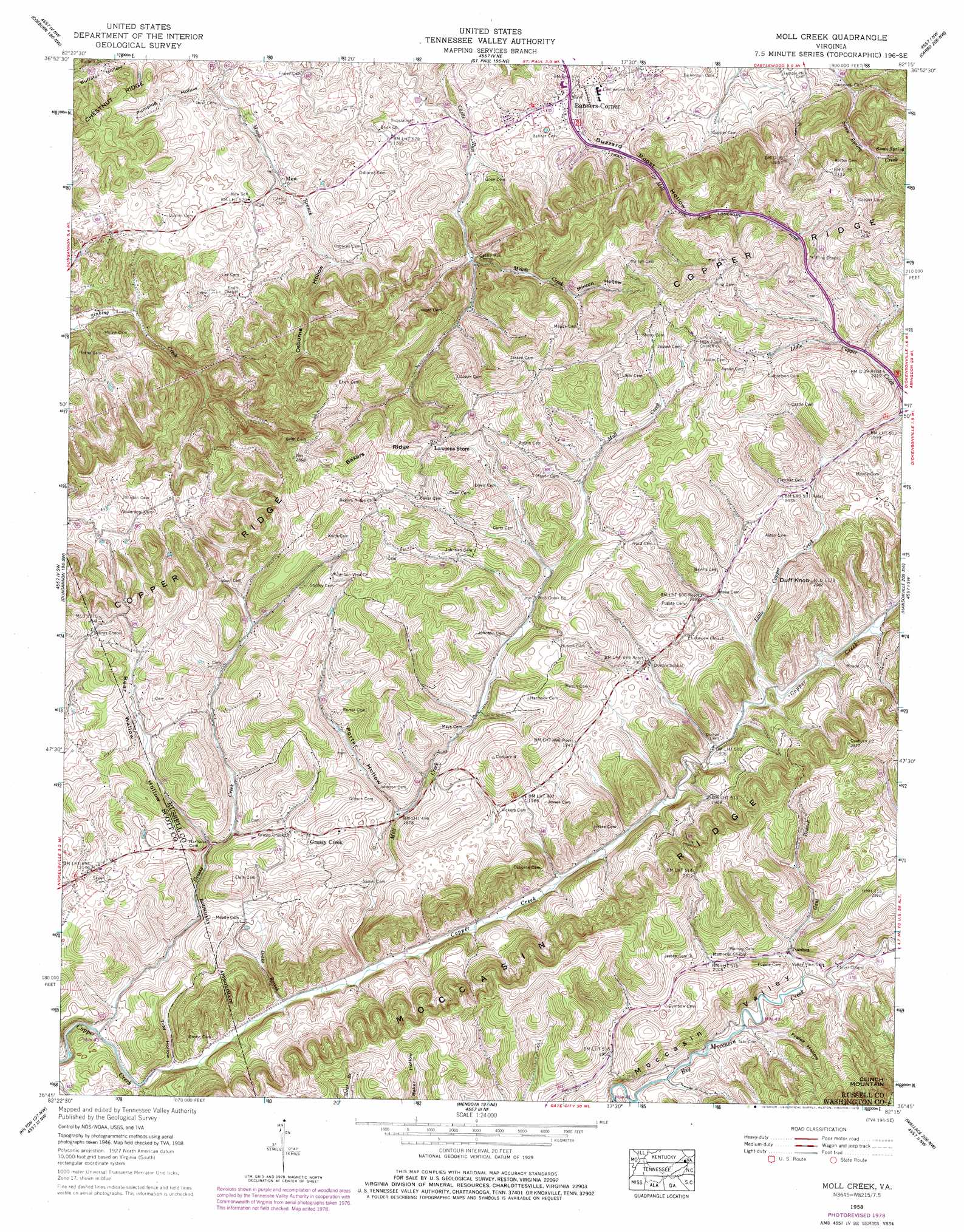
Moll Creek Topo Map Virginia
To zoom in, hover over the map of Moll Creek
USGS Topo Quad 36082g3 - 1:24,000 scale
| Topo Map Name: | Moll Creek |
| USGS Topo Quad ID: | 36082g3 |
| Print Size: | ca. 21 1/4" wide x 27" high |
| Southeast Coordinates: | 36.75° N latitude / 82.25° W longitude |
| Map Center Coordinates: | 36.8125° N latitude / 82.3125° W longitude |
| U.S. State: | VA |
| Filename: | o36082g3.jpg |
| Download Map JPG Image: | Moll Creek topo map 1:24,000 scale |
| Map Type: | Topographic |
| Topo Series: | 7.5´ |
| Map Scale: | 1:24,000 |
| Source of Map Images: | United States Geological Survey (USGS) |
| Alternate Map Versions: |
Moll Creek VA 1935 Download PDF Buy paper map Moll Creek VA 1958, updated 1960 Download PDF Buy paper map Moll Creek VA 1958, updated 1960 Download PDF Buy paper map Moll Creek VA 1958, updated 1974 Download PDF Buy paper map Moll Creek VA 1958, updated 1978 Download PDF Buy paper map Moll Creek VA 1958, updated 1978 Download PDF Buy paper map Moll Creek VA 2010 Download PDF Buy paper map Moll Creek VA 2013 Download PDF Buy paper map Moll Creek VA 2016 Download PDF Buy paper map |
1:24,000 Topo Quads surrounding Moll Creek
Pound |
Caney Ridge |
Nora |
Duty |
Big A Mountain |
Wise |
Coeburn |
Saint Paul |
Carbo |
Lebanon |
Fort Blackmore |
Dungannon |
Moll Creek |
Hansonville |
Brumley |
Gate City |
Hilton |
Mendota |
Wallace |
Wyndale |
Kingsport |
Indian Springs |
Blountville |
Bristol |
Holston Valley |
> Back to 36082e1 at 1:100,000 scale
> Back to 36082a1 at 1:250,000 scale
> Back to U.S. Topo Maps home
Moll Creek topo map: Gazetteer
Moll Creek: Populated Places
Banners Corner elevation 536m 1758′Grassy Creek elevation 630m 2066′
Masons Store (historical) elevation 585m 1919′
Mew elevation 537m 1761′
Point Truth elevation 600m 1968′
Tumbez elevation 586m 1922′
Moll Creek: Ridges
Bakers Ridge elevation 712m 2335′Moll Creek: Springs
Seven Spring elevation 619m 2030′Moll Creek: Streams
Drake Branch elevation 540m 1771′Gant Branch elevation 579m 1899′
Grassy Creek elevation 534m 1751′
Little Copper Creek elevation 566m 1856′
Meade Creek elevation 568m 1863′
Mill Creek elevation 522m 1712′
Moll Creek elevation 542m 1778′
Moll Creek: Summits
Duff Knob elevation 711m 2332′Moll Creek: Valleys
Buzzard Roost Hollow elevation 522m 1712′Fraley Hollow elevation 591m 1938′
Minton Hollow elevation 604m 1981′
Osborne Hollow elevation 554m 1817′
Porter Hollow elevation 575m 1886′
Pumplog Hollow elevation 523m 1715′
Tray Hollow elevation 538m 1765′
Wallow Hollow elevation 592m 1942′
Moll Creek digital topo map on disk
Buy this Moll Creek topo map showing relief, roads, GPS coordinates and other geographical features, as a high-resolution digital map file on DVD:
Western Virginia & Southern West Virginia
Buy digital topo maps: Western Virginia & Southern West Virginia