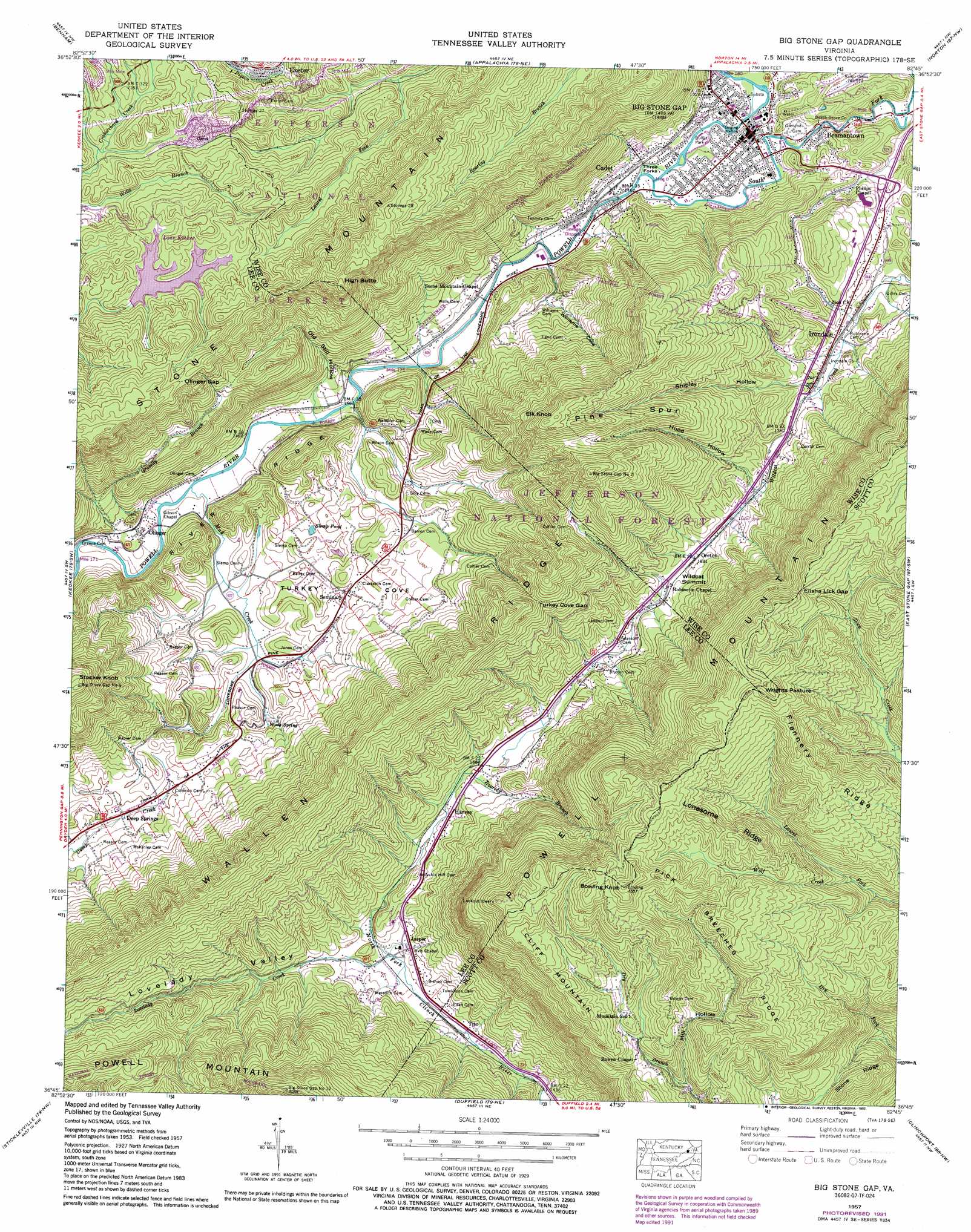
Big Stone Gap Topo Map Virginia
To zoom in, hover over the map of Big Stone Gap
USGS Topo Quad 36082g7 - 1:24,000 scale
| Topo Map Name: | Big Stone Gap |
| USGS Topo Quad ID: | 36082g7 |
| Print Size: | ca. 21 1/4" wide x 27" high |
| Southeast Coordinates: | 36.75° N latitude / 82.75° W longitude |
| Map Center Coordinates: | 36.8125° N latitude / 82.8125° W longitude |
| U.S. State: | VA |
| Filename: | o36082g7.jpg |
| Download Map JPG Image: | Big Stone Gap topo map 1:24,000 scale |
| Map Type: | Topographic |
| Topo Series: | 7.5´ |
| Map Scale: | 1:24,000 |
| Source of Map Images: | United States Geological Survey (USGS) |
| Alternate Map Versions: |
Olinger VA 1935 Download PDF Buy paper map Big Stone Gap VA 1957, updated 1959 Download PDF Buy paper map Big Stone Gap VA 1957, updated 1959 Download PDF Buy paper map Big Stone Gap VA 1957, updated 1968 Download PDF Buy paper map Big Stone Gap VA 1957, updated 1970 Download PDF Buy paper map Big Stone Gap VA 1957, updated 1978 Download PDF Buy paper map Big Stone Gap VA 1957, updated 1992 Download PDF Buy paper map Big Stone Gap VA 1976, updated 1981 Download PDF Buy paper map Big Stone Gap VA 2011 Download PDF Buy paper map Big Stone Gap VA 2013 Download PDF Buy paper map Big Stone Gap VA 2016 Download PDF Buy paper map |
| FStopo: | US Forest Service topo Big Stone Gap is available: Download FStopo PDF Download FStopo TIF |
1:24,000 Topo Quads surrounding Big Stone Gap
Tilford |
Roxana |
Whitesburg |
Flat Gap |
Pound |
Louellen |
Benham |
Appalachia |
Norton |
Wise |
Pennington Gap |
Keokee |
Big Stone Gap |
East Stone Gap |
Fort Blackmore |
Ben Hur |
Stickleyville |
Duffield |
Clinchport |
Gate City |
Kyles Ford |
Looneys Gap |
Plum Grove |
Church Hill |
Kingsport |
> Back to 36082e1 at 1:100,000 scale
> Back to 36082a1 at 1:250,000 scale
> Back to U.S. Topo Maps home
Big Stone Gap topo map: Gazetteer
Big Stone Gap: Areas
Three Forks elevation 445m 1459′Big Stone Gap: Basins
Turkey elevation 489m 1604′Big Stone Gap: Bridges
Hugh Williams Memorial Bridge elevation 450m 1476′Big Stone Gap: Dams
Lake Keokee Dam elevation 685m 2247′Big Stone Gap: Flats
Wrights Pasture elevation 1031m 3382′Big Stone Gap: Gaps
Elisha Lick Gap elevation 970m 3182′Olinger Gap elevation 800m 2624′
Turkey Cove Gap elevation 753m 2470′
Wildcat Summit elevation 592m 1942′
Big Stone Gap: Lakes
Slemp Pond elevation 474m 1555′Big Stone Gap: Parks
Bullit Park elevation 449m 1473′Big Stone Gap: Populated Places
Beamantown elevation 459m 1505′Cadet elevation 443m 1453′
Deep Springs elevation 468m 1535′
Goodloe (historical) elevation 659m 2162′
Harvey elevation 502m 1646′
Irondale elevation 526m 1725′
Jasper elevation 479m 1571′
Olinger elevation 449m 1473′
Oreton elevation 573m 1879′
Seminary elevation 488m 1601′
Tito elevation 450m 1476′
Big Stone Gap: Ranges
Stone Mountain elevation 910m 2985′Big Stone Gap: Reservoirs
Keokee Lake elevation 685m 2247′Lake Keokee elevation 687m 2253′
Big Stone Gap: Ridges
Flannery Ridge elevation 974m 3195′Lonesome Ridge elevation 973m 3192′
Pick Breeches Ridge elevation 900m 2952′
Pine Spur elevation 823m 2700′
Big Stone Gap: Springs
Wake Spring elevation 462m 1515′Big Stone Gap: Streams
Buck Creek elevation 434m 1423′Gravely Branch elevation 432m 1417′
Lovelady Creek elevation 462m 1515′
Roaring Branch elevation 507m 1663′
South Fork Powell River elevation 442m 1450′
Wolf Creek elevation 728m 2388′
Big Stone Gap: Summits
Bowling Knob elevation 1075m 3526′Cliff Mountain elevation 934m 3064′
Elk Knob elevation 940m 3083′
High Butte elevation 928m 3044′
Stocker Knob elevation 880m 2887′
Big Stone Gap: Valleys
Hood Hollow elevation 575m 1886′Lovelady Valley elevation 463m 1519′
Mill Hollow elevation 689m 2260′
Old Still Hollow elevation 439m 1440′
Shipley Hollow elevation 551m 1807′
Williams Cove elevation 447m 1466′
Big Stone Gap digital topo map on disk
Buy this Big Stone Gap topo map showing relief, roads, GPS coordinates and other geographical features, as a high-resolution digital map file on DVD:
Western Virginia & Southern West Virginia
Buy digital topo maps: Western Virginia & Southern West Virginia