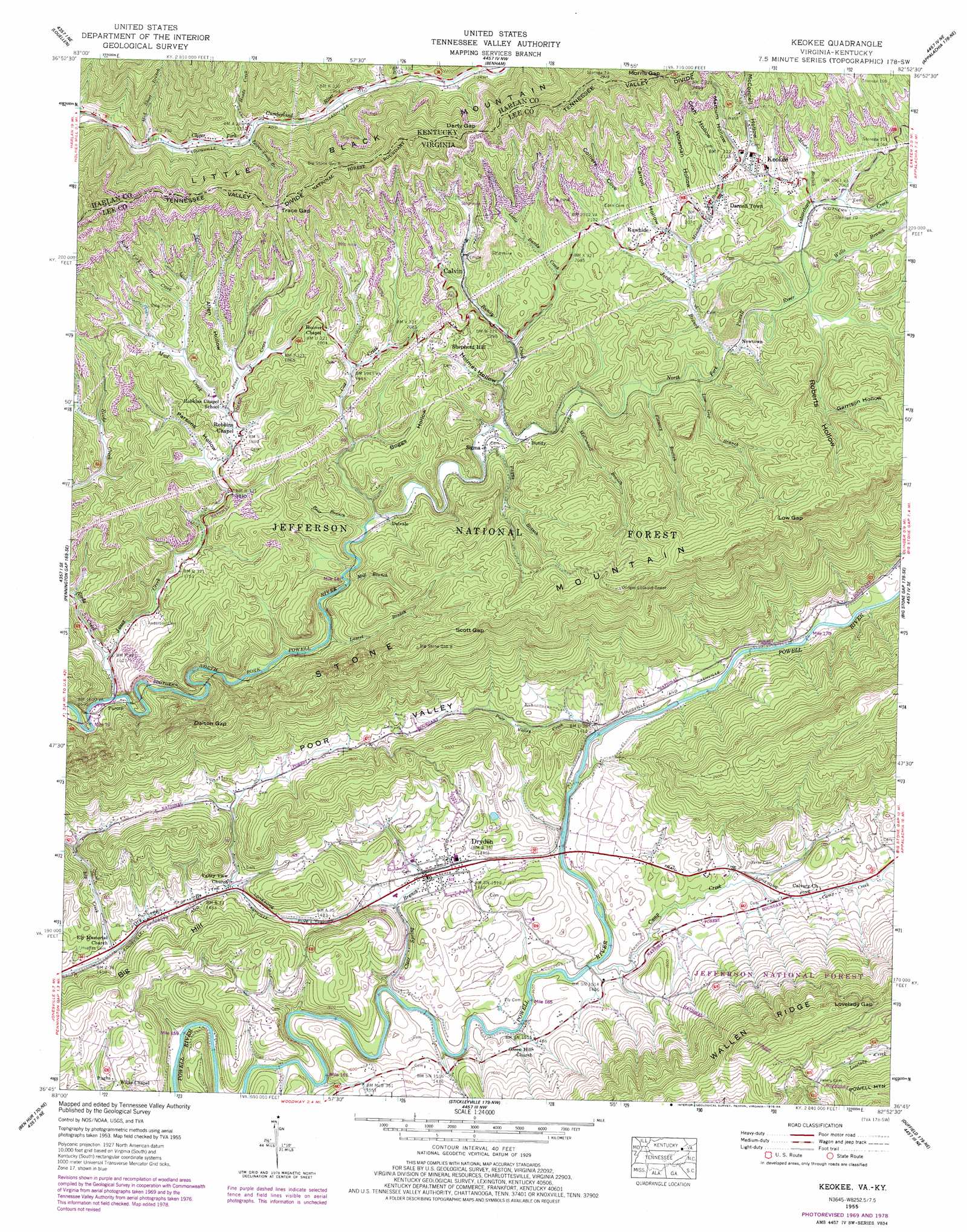
Keokee Topo Map Virginia
To zoom in, hover over the map of Keokee
USGS Topo Quad 36082g8 - 1:24,000 scale
| Topo Map Name: | Keokee |
| USGS Topo Quad ID: | 36082g8 |
| Print Size: | ca. 21 1/4" wide x 27" high |
| Southeast Coordinates: | 36.75° N latitude / 82.875° W longitude |
| Map Center Coordinates: | 36.8125° N latitude / 82.9375° W longitude |
| U.S. States: | VA, KY |
| Filename: | o36082g8.jpg |
| Download Map JPG Image: | Keokee topo map 1:24,000 scale |
| Map Type: | Topographic |
| Topo Series: | 7.5´ |
| Map Scale: | 1:24,000 |
| Source of Map Images: | United States Geological Survey (USGS) |
| Alternate Map Versions: |
Keokee VA 1935 Download PDF Buy paper map Keokee VA 1955, updated 1956 Download PDF Buy paper map Keokee VA 1955, updated 1956 Download PDF Buy paper map Keokee VA 1955, updated 1966 Download PDF Buy paper map Keokee VA 1955, updated 1970 Download PDF Buy paper map Keokee VA 1955, updated 1978 Download PDF Buy paper map Keokee VA 1955, updated 1984 Download PDF Buy paper map Keokee VA 1976, updated 1981 Download PDF Buy paper map Keokee VA 2011 Download PDF Buy paper map Keokee VA 2013 Download PDF Buy paper map Keokee VA 2016 Download PDF Buy paper map |
| FStopo: | US Forest Service topo Keokee is available: Download FStopo PDF Download FStopo TIF |
1:24,000 Topo Quads surrounding Keokee
Leatherwood |
Tilford |
Roxana |
Whitesburg |
Flat Gap |
Nolansburg |
Louellen |
Benham |
Appalachia |
Norton |
Evarts |
Pennington Gap |
Keokee |
Big Stone Gap |
East Stone Gap |
Hubbard Springs |
Ben Hur |
Stickleyville |
Duffield |
Clinchport |
Sneedville |
Kyles Ford |
Looneys Gap |
Plum Grove |
Church Hill |
> Back to 36082e1 at 1:100,000 scale
> Back to 36082a1 at 1:250,000 scale
> Back to U.S. Topo Maps home
Keokee topo map: Gazetteer
Keokee: Crossings
De Busk Ford elevation 410m 1345′Stallard Ford elevation 422m 1384′
Keokee: Gaps
Big Stone Gap 6 elevation 863m 2831′Dalton Gap elevation 717m 2352′
Darty Gap elevation 855m 2805′
Darty Gap elevation 793m 2601′
Lovelady Gap elevation 815m 2673′
Low Gap elevation 862m 2828′
Morris Gap elevation 791m 2595′
Morris Gap elevation 817m 2680′
Scott Gap elevation 797m 2614′
Trace Gap elevation 737m 2417′
Trace Gap elevation 731m 2398′
Keokee: Populated Places
Buckles (historical) elevation 571m 1873′Bundy elevation 616m 2020′
Calvin elevation 620m 2034′
Darnell Town elevation 647m 2122′
Delvale elevation 580m 1902′
Dryden elevation 439m 1440′
Ely elevation 424m 1391′
Johnsons Mill (historical) elevation 612m 2007′
Keokee elevation 634m 2080′
Mill Branch (historical) elevation 551m 1807′
Mohawk (historical) elevation 639m 2096′
Newtown elevation 623m 2043′
Pughs elevation 490m 1607′
Purcell elevation 490m 1607′
Rawhide elevation 629m 2063′
Robbins (historical) elevation 544m 1784′
Shepherd Hill elevation 661m 2168′
Sigma elevation 607m 1991′
Keokee: Streams
Bear Branch elevation 566m 1856′Bundy Creek elevation 602m 1975′
Camp Creek elevation 425m 1394′
Clear Spring Branch elevation 414m 1358′
Cox Creek elevation 571m 1873′
Craborchard Creek elevation 628m 2060′
Ely Creek elevation 422m 1384′
Flanary Branch elevation 620m 2034′
Haupts Branch elevation 593m 1945′
Heads Creek elevation 588m 1929′
Huff Creek elevation 609m 1998′
Jack Bailey Branch elevation 556m 1824′
Jones Creek elevation 485m 1591′
Jordon Branch elevation 622m 2040′
Laurel Branch elevation 543m 1781′
Lick Branch elevation 548m 1797′
Little Bundy Creek elevation 606m 1988′
Low Gap Branch elevation 618m 2027′
Lower Trace Branch elevation 604m 1981′
Marcum Branch elevation 584m 1916′
McConnell Branch elevation 609m 1998′
Meadow Branch elevation 622m 2040′
Med Short Branch elevation 564m 1850′
Moore Branch elevation 630m 2066′
Mud Creek elevation 559m 1833′
Payne Branch elevation 605m 1984′
Poor Valley Creek elevation 425m 1394′
Reeds Creek elevation 484m 1587′
Right Fork Jones Creek elevation 564m 1850′
Right Fork Mud Creek elevation 566m 1856′
Wells Branch elevation 626m 2053′
Keokee: Summits
Big Hill elevation 586m 1922′Keokee: Valleys
Allen Hollow elevation 566m 1856′Boggs Hollow elevation 602m 1975′
Carroll Hollow elevation 629m 2063′
Colliers Cove elevation 635m 2083′
Craft Hollow elevation 646m 2119′
Garrison Hollow elevation 718m 2355′
Holmes Hollow elevation 616m 2020′
Marcum Hollow elevation 654m 2145′
McConnell Hollow elevation 667m 2188′
Parsons Hollow elevation 554m 1817′
Roberts Hollow elevation 630m 2066′
Whisman Hollow elevation 631m 2070′
Keokee digital topo map on disk
Buy this Keokee topo map showing relief, roads, GPS coordinates and other geographical features, as a high-resolution digital map file on DVD:
Western Virginia & Southern West Virginia
Buy digital topo maps: Western Virginia & Southern West Virginia