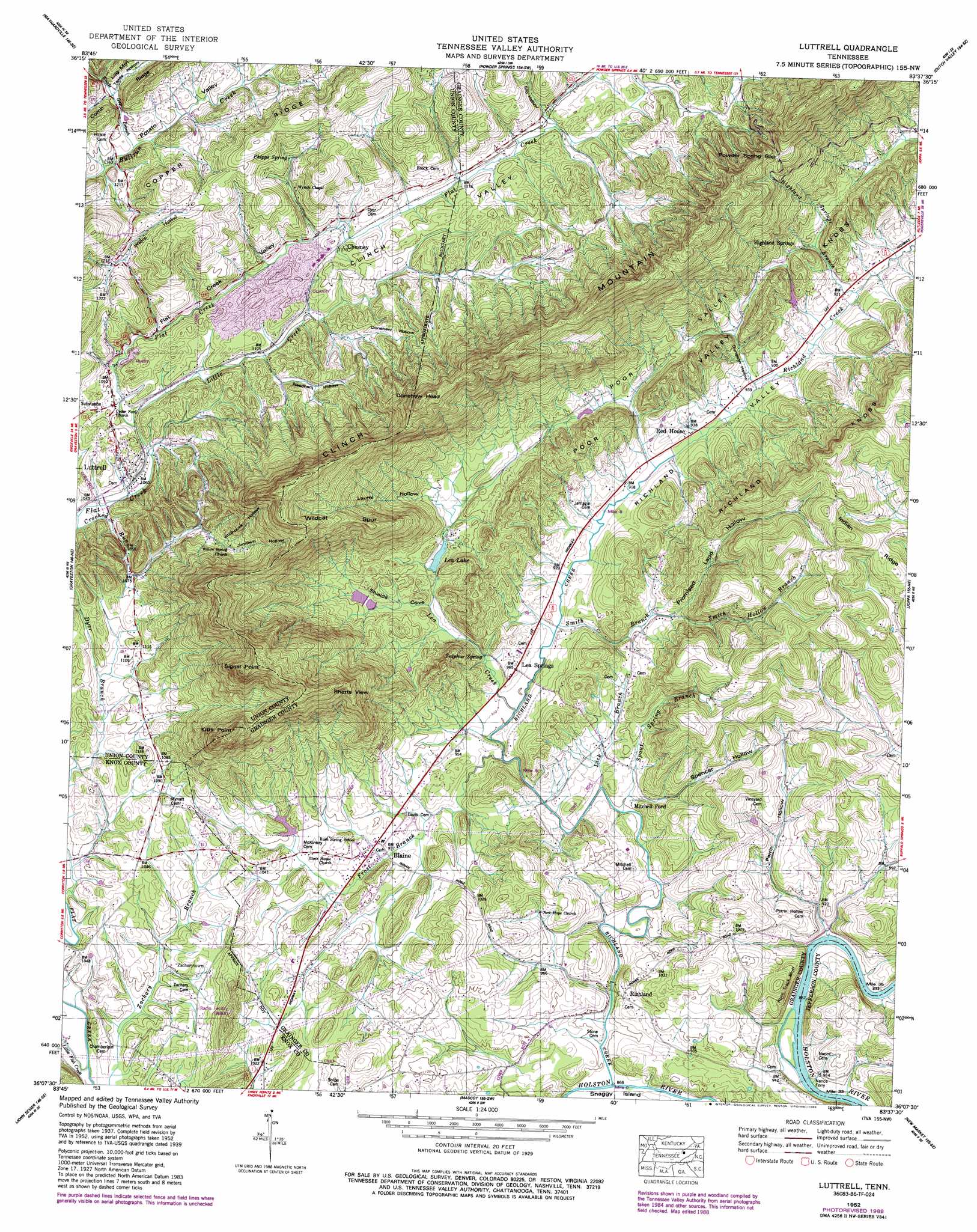
Luttrell Topo Map Tennessee
To zoom in, hover over the map of Luttrell
USGS Topo Quad 36083b6 - 1:24,000 scale
| Topo Map Name: | Luttrell |
| USGS Topo Quad ID: | 36083b6 |
| Print Size: | ca. 21 1/4" wide x 27" high |
| Southeast Coordinates: | 36.125° N latitude / 83.625° W longitude |
| Map Center Coordinates: | 36.1875° N latitude / 83.6875° W longitude |
| U.S. State: | TN |
| Filename: | o36083b6.jpg |
| Download Map JPG Image: | Luttrell topo map 1:24,000 scale |
| Map Type: | Topographic |
| Topo Series: | 7.5´ |
| Map Scale: | 1:24,000 |
| Source of Map Images: | United States Geological Survey (USGS) |
| Alternate Map Versions: |
Luttrell TN 1935 Download PDF Buy paper map Luttrell TN 1939 Download PDF Buy paper map Luttrell TN 1952, updated 1954 Download PDF Buy paper map Luttrell TN 1952, updated 1975 Download PDF Buy paper map Luttrell TN 1952, updated 1978 Download PDF Buy paper map Luttrell TN 1952, updated 1988 Download PDF Buy paper map Luttrell TN 2010 Download PDF Buy paper map Luttrell TN 2013 Download PDF Buy paper map Luttrell TN 2016 Download PDF Buy paper map |
1:24,000 Topo Quads surrounding Luttrell
Well Spring |
Ausmus |
Clouds |
Tazewell |
Howard Quarter |
White Hollow |
Maynardville |
Powder Springs |
Dutch Valley |
Avondale |
Big Ridge Park |
Graveston |
Luttrell |
Joppa |
Talbott |
Fountain City |
John Sevier |
Mascot |
New Market |
Jefferson City |
Knoxville |
Shooks Gap |
Boyds Creek |
Douglas Dam |
Shady Grove |
> Back to 36083a1 at 1:100,000 scale
> Back to 36082a1 at 1:250,000 scale
> Back to U.S. Topo Maps home
Luttrell topo map: Gazetteer
Luttrell: Bars
Nances Shoals elevation 265m 869′Luttrell: Cliffs
Kitts Point elevation 609m 1998′Race Track Bluff elevation 314m 1030′
Signal Point elevation 700m 2296′
Luttrell: Crossings
Mitchell Ford elevation 285m 935′Nance Ferry elevation 265m 869′
Luttrell: Dams
Highland Springs Cove Dam elevation 302m 990′Lea Lake Dam elevation 308m 1010′
Luttrell: Flats
Chestnut Flat elevation 588m 1929′Luttrell: Gaps
Powder Spring Gap elevation 538m 1765′Luttrell: Islands
Nances Island elevation 272m 892′Luttrell: Mines
Republic Quarry elevation 333m 1092′Luttrell: Populated Places
Ailor (historical) elevation 366m 1200′Blaine elevation 293m 961′
Chesney elevation 347m 1138′
Highland Springs elevation 312m 1023′
Highlands (historical) elevation 285m 935′
Lea Springs elevation 294m 964′
Luttrell elevation 328m 1076′
Maples (historical) elevation 304m 997′
Perrin Hollow elevation 280m 918′
Richland elevation 285m 935′
Zacharytown elevation 322m 1056′
Luttrell: Reservoirs
Highland Springs Cove Lake elevation 302m 990′Lea Lake elevation 308m 1010′
Luttrell: Ridges
Wildcat Spur elevation 524m 1719′Luttrell: Springs
Heatherly Spring elevation 280m 918′Sulphur Spring elevation 279m 915′
Luttrell: Streams
Crooked Run elevation 312m 1023′Dyer Branch elevation 298m 977′
Frost Branch elevation 277m 908′
Hamilton Gap Branch elevation 366m 1200′
Highland Springs Branch elevation 280m 918′
Lea Creek elevation 275m 902′
Leas Creek elevation 273m 895′
Lick Branch elevation 280m 918′
Little Creek elevation 321m 1053′
Little Flat Creek elevation 292m 958′
Richland Creek elevation 265m 869′
Smith Branch elevation 277m 908′
Smith Hollow Branch elevation 304m 997′
Spout Spring Branch elevation 271m 889′
Woods Gap Branch elevation 354m 1161′
Luttrell: Summits
Donehew Head elevation 643m 2109′Rhetts View elevation 500m 1640′
Luttrell: Valleys
Booker Hollow elevation 366m 1200′Clinch Valley elevation 328m 1076′
Donehew Hollow elevation 344m 1128′
Dungeon Hollow elevation 282m 925′
Flat Creek Valley elevation 325m 1066′
Jimtown Hollow elevation 365m 1197′
Laurel Hollow elevation 296m 971′
Needham Hollow elevation 335m 1099′
Perrin Hollow elevation 269m 882′
Poor Valley elevation 284m 931′
Promised Land Hollow elevation 310m 1017′
Richland Valley elevation 280m 918′
Shields Cove elevation 280m 918′
Silo Hollow elevation 363m 1190′
Smith Hollow elevation 313m 1026′
Spencer Hollow elevation 277m 908′
Stillhouse Hollow elevation 391m 1282′
Texas Hollow elevation 401m 1315′
Wallop Hollow elevation 371m 1217′
Luttrell digital topo map on disk
Buy this Luttrell topo map showing relief, roads, GPS coordinates and other geographical features, as a high-resolution digital map file on DVD:
Western Virginia & Southern West Virginia
Buy digital topo maps: Western Virginia & Southern West Virginia