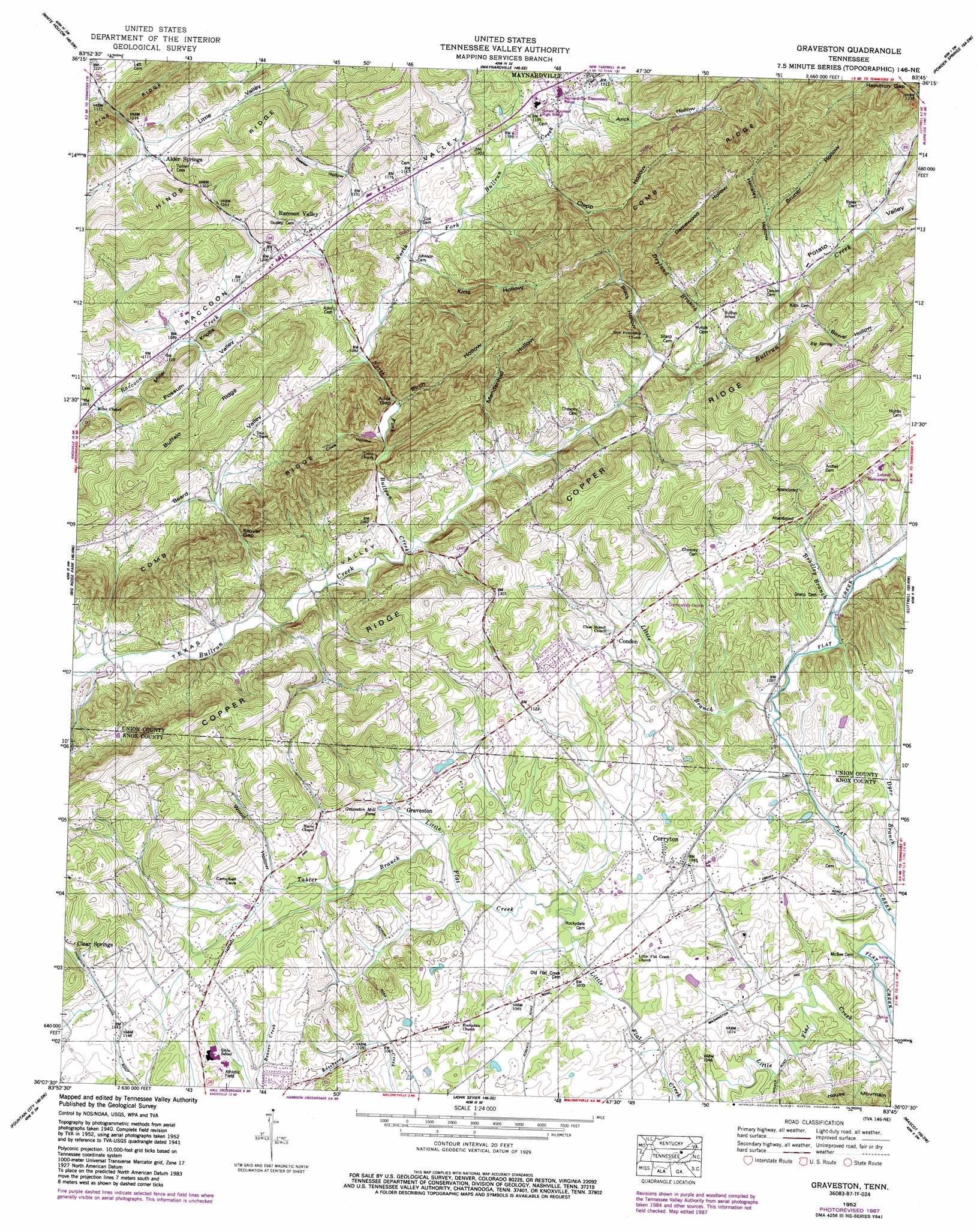
Graveston Topo Map Tennessee
To zoom in, hover over the map of Graveston
USGS Topo Quad 36083b7 - 1:24,000 scale
| Topo Map Name: | Graveston |
| USGS Topo Quad ID: | 36083b7 |
| Print Size: | ca. 21 1/4" wide x 27" high |
| Southeast Coordinates: | 36.125° N latitude / 83.75° W longitude |
| Map Center Coordinates: | 36.1875° N latitude / 83.8125° W longitude |
| U.S. State: | TN |
| Filename: | o36083b7.jpg |
| Download Map JPG Image: | Graveston topo map 1:24,000 scale |
| Map Type: | Topographic |
| Topo Series: | 7.5´ |
| Map Scale: | 1:24,000 |
| Source of Map Images: | United States Geological Survey (USGS) |
| Alternate Map Versions: |
Graveston TN 1935 Download PDF Buy paper map Graveston TN 1941 Download PDF Buy paper map Graveston TN 1941 Download PDF Buy paper map Graveston TN 1952, updated 1954 Download PDF Buy paper map Graveston TN 1952, updated 1976 Download PDF Buy paper map Graveston TN 1952, updated 1984 Download PDF Buy paper map Graveston TN 1952, updated 1988 Download PDF Buy paper map Graveston TN 2010 Download PDF Buy paper map Graveston TN 2013 Download PDF Buy paper map Graveston TN 2016 Download PDF Buy paper map |
1:24,000 Topo Quads surrounding Graveston
La Follette |
Well Spring |
Ausmus |
Clouds |
Tazewell |
Demory |
White Hollow |
Maynardville |
Powder Springs |
Dutch Valley |
Norris |
Big Ridge Park |
Graveston |
Luttrell |
Joppa |
Powell |
Fountain City |
John Sevier |
Mascot |
New Market |
Bearden |
Knoxville |
Shooks Gap |
Boyds Creek |
Douglas Dam |
> Back to 36083a1 at 1:100,000 scale
> Back to 36082a1 at 1:250,000 scale
> Back to U.S. Topo Maps home
Graveston topo map: Gazetteer
Graveston: Dams
Thunder Hollow Dam elevation 322m 1056′Graveston: Gaps
Ailor Gap elevation 327m 1072′Hamilton Gap elevation 380m 1246′
Stover Gap elevation 325m 1066′
Graveston: Lakes
Graveston Mill Pond elevation 323m 1059′Graveston: Populated Places
Alder Springs elevation 378m 1240′Condon elevation 346m 1135′
Corryton elevation 321m 1053′
Graveston elevation 322m 1056′
House Mountain (historical) elevation 303m 994′
Pleasant Valley elevation 319m 1046′
Raccoon Valley elevation 365m 1197′
Woodburn (historical) elevation 379m 1243′
Graveston: Post Offices
Corryton Post Office elevation 318m 1043′Graveston: Reservoirs
Thunder Hollow Lake elevation 322m 1056′Graveston: Ridges
Buffalo Ridge elevation 456m 1496′Comb Ridge elevation 490m 1607′
Graveston: Springs
Big Spring elevation 376m 1233′Graveston: Streams
Bradley Branch elevation 311m 1020′Dryland Branch elevation 328m 1076′
Little Branch elevation 302m 990′
North Fork Bullrun Creek elevation 308m 1010′
Tabler Branch elevation 316m 1036′
Graveston: Summits
Miller Knobs elevation 394m 1292′Graveston: Valleys
Arick Hollow elevation 358m 1174′Beeler Hollow elevation 369m 1210′
Birch Hollow elevation 326m 1069′
Black Hollow elevation 325m 1066′
Bower Hollow elevation 349m 1145′
Bruner Hollow elevation 374m 1227′
Clapp Hollow elevation 352m 1154′
Cove Hollow elevation 330m 1082′
Damewood Hollow elevation 383m 1256′
Hensley Hollow elevation 352m 1154′
Kitts Hollow elevation 347m 1138′
Mendenhall Hollow elevation 333m 1092′
Potato Valley elevation 360m 1181′
Wood Hollow elevation 340m 1115′
Graveston digital topo map on disk
Buy this Graveston topo map showing relief, roads, GPS coordinates and other geographical features, as a high-resolution digital map file on DVD:
Western Virginia & Southern West Virginia
Buy digital topo maps: Western Virginia & Southern West Virginia