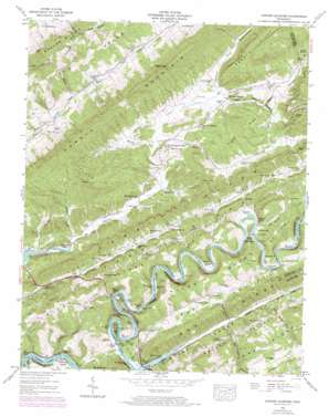
Howard Quarter Topo Map Tennessee
To zoom in, hover over the map of Howard Quarter
USGS Topo Quad 36083d4 - 1:24,000 scale
| Topo Map Name: | Howard Quarter |
| USGS Topo Quad ID: | 36083d4 |
| Print Size: | ca. 21 1/4" wide x 27" high |
| Southeast Coordinates: | 36.375° N latitude / 83.375° W longitude |
| Map Center Coordinates: | 36.4375° N latitude / 83.4375° W longitude |
| U.S. State: | TN |
| Filename: | o36083d4.jpg |
| Download Map JPG Image: | Howard Quarter topo map 1:24,000 scale |
| Map Type: | Topographic |
| Topo Series: | 7.5´ |
| Map Scale: | 1:24,000 |
| Source of Map Images: | United States Geological Survey (USGS) |
| Alternate Map Versions: |
Howard Quarter TN 1935 Download PDF Buy paper map Howard Quarter TN 1942, updated 1957 Download PDF Buy paper map Howard Quarter TN 1942, updated 1973 Download PDF Buy paper map Howard Quarter TN 1943, updated 1946 Download PDF Buy paper map Howard Quarter TN 1943, updated 1946 Download PDF Buy paper map Howard Quarter TN 2010 Download PDF Buy paper map Howard Quarter TN 2013 Download PDF Buy paper map Howard Quarter TN 2016 Download PDF Buy paper map |
1:24,000 Topo Quads surrounding Howard Quarter
> Back to 36083a1 at 1:100,000 scale
> Back to 36082a1 at 1:250,000 scale
> Back to U.S. Topo Maps home
Howard Quarter topo map: Gazetteer
Howard Quarter: Bends
Lee Bend elevation 358m 1174′Posey Bend elevation 366m 1200′
Howard Quarter: Bridges
Evans Ferry Bridge elevation 311m 1020′Howard Quarter: Crossings
Cades Ferry (historical) elevation 313m 1026′Evans Ferry (historical) elevation 311m 1020′
Howard Quarter: Gaps
Fugate Gap elevation 661m 2168′The Narrows elevation 335m 1099′
Tip Gap elevation 383m 1256′
Howard Quarter: Islands
Grissom Island elevation 326m 1069′Howard Quarter: Populated Places
Caney Valley elevation 362m 1187′Howard Quarter elevation 343m 1125′
Raven Hill elevation 435m 1427′
Ritchie elevation 389m 1276′
Howard Quarter: Rapids
Bulls Shoals elevation 329m 1079′Johnsons Shoals elevation 328m 1076′
Macks Shoals elevation 331m 1085′
Howard Quarter: Ridges
Brushy Ridge elevation 525m 1722′Caney Ridge elevation 438m 1437′
Comby Ridge elevation 515m 1689′
Little Ridge elevation 548m 1797′
River Ridge elevation 463m 1519′
Skaggs Ridge elevation 695m 2280′
Howard Quarter: Springs
Dodson Spring elevation 407m 1335′Howard Quarter: Streams
Cedar Springs Creek elevation 324m 1062′Forked Deer Creek elevation 311m 1020′
Indian Creek elevation 311m 1020′
Jennings Branch elevation 314m 1030′
Joe Mill Creek elevation 320m 1049′
Kelly Branch elevation 321m 1053′
Machine Branch elevation 321m 1053′
Middle Fork Sycamore Creek elevation 366m 1200′
Patterson Branch elevation 325m 1066′
Rucker Branch elevation 391m 1282′
Seal Branch elevation 327m 1072′
Skaggs Creek elevation 313m 1026′
South Fork Sycamore Creek elevation 340m 1115′
Sycamore Creek elevation 329m 1079′
Howard Quarter: Summits
Big Hollow Hill elevation 509m 1669′Butt of Newmans Ridge elevation 558m 1830′
Sharp Mountain elevation 694m 2276′
Howard Quarter: Valleys
Baker Hollow elevation 384m 1259′Big Hollow elevation 338m 1108′
Buck Lick Hollow elevation 331m 1085′
Cunningham Hollow elevation 398m 1305′
Dry Valley elevation 312m 1023′
Hensley Hollow elevation 373m 1223′
Indian Creek Valley elevation 311m 1020′
Ivy Hollow elevation 321m 1053′
Little Broken Valley elevation 314m 1030′
Little Caney Valley elevation 362m 1187′
Little Valley elevation 398m 1305′
Snake Hollow elevation 341m 1118′
Howard Quarter digital topo map on disk
Buy this Howard Quarter topo map showing relief, roads, GPS coordinates and other geographical features, as a high-resolution digital map file on DVD:
Western Virginia & Southern West Virginia
Buy digital topo maps: Western Virginia & Southern West Virginia


