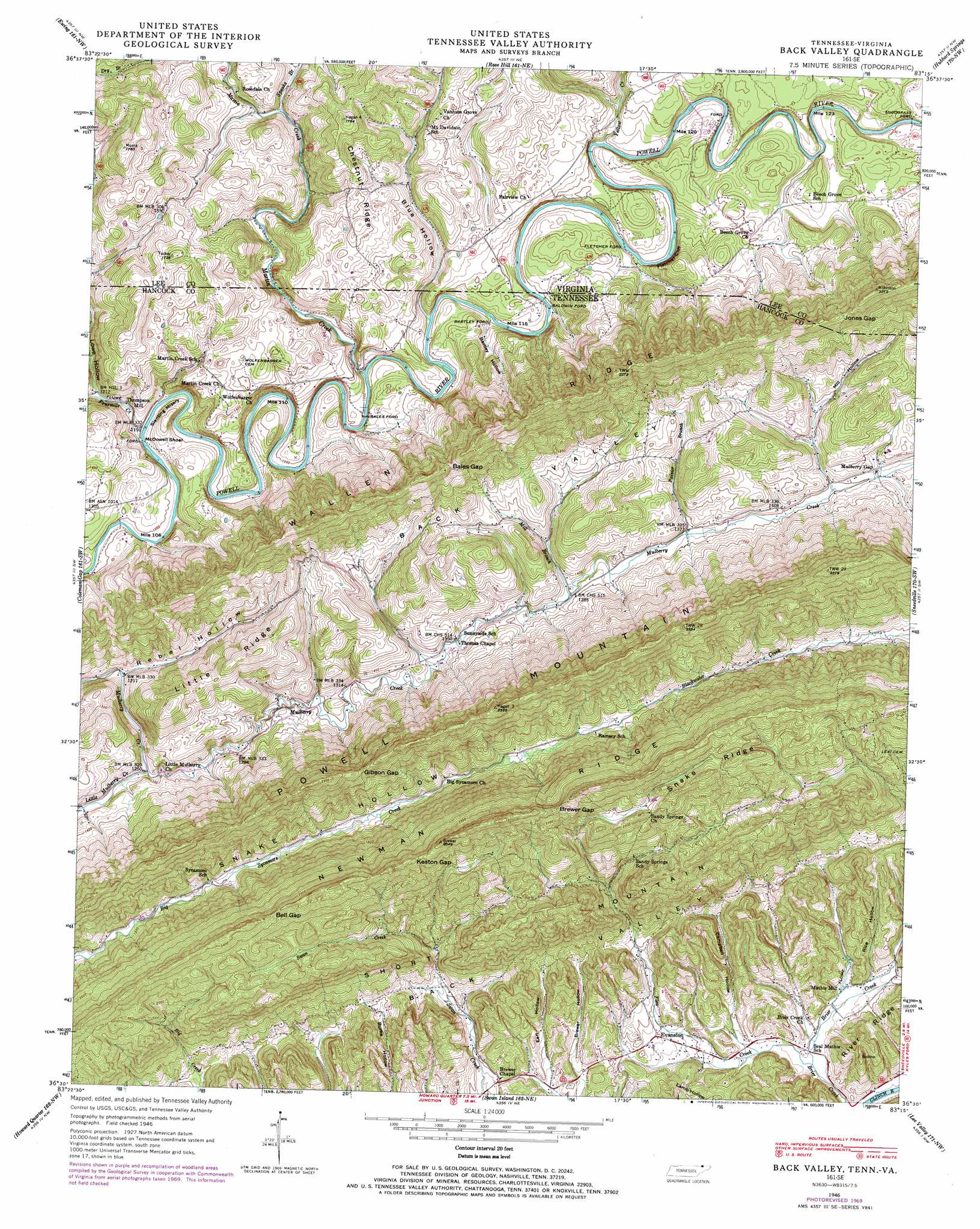
Back Valley Topo Map Tennessee
To zoom in, hover over the map of Back Valley
USGS Topo Quad 36083e3 - 1:24,000 scale
| Topo Map Name: | Back Valley |
| USGS Topo Quad ID: | 36083e3 |
| Print Size: | ca. 21 1/4" wide x 27" high |
| Southeast Coordinates: | 36.5° N latitude / 83.25° W longitude |
| Map Center Coordinates: | 36.5625° N latitude / 83.3125° W longitude |
| U.S. States: | TN, VA |
| Filename: | o36083e3.jpg |
| Download Map JPG Image: | Back Valley topo map 1:24,000 scale |
| Map Type: | Topographic |
| Topo Series: | 7.5´ |
| Map Scale: | 1:24,000 |
| Source of Map Images: | United States Geological Survey (USGS) |
| Alternate Map Versions: |
Back Valley TN 1935 Download PDF Buy paper map Back Valley TN 1946, updated 1965 Download PDF Buy paper map Back Valley TN 1946, updated 1970 Download PDF Buy paper map Back Valley TN 1976, updated 1981 Download PDF Buy paper map Back Valley TN 2011 Download PDF Buy paper map Back Valley TN 2013 Download PDF Buy paper map Back Valley TN 2016 Download PDF Buy paper map |
1:24,000 Topo Quads surrounding Back Valley
Balkan |
Wallins Creek |
Harlan |
Evarts |
Pennington Gap |
Varilla |
Ewing |
Rose Hill |
Hubbard Springs |
Ben Hur |
Wheeler |
Coleman Gap |
Back Valley |
Sneedville |
Kyles Ford |
Tazewell |
Howard Quarter |
Swan Island |
Lee Valley |
Camelot |
Dutch Valley |
Avondale |
Bean Station |
Russellville |
Bulls Gap |
> Back to 36083e1 at 1:100,000 scale
> Back to 36082a1 at 1:250,000 scale
> Back to U.S. Topo Maps home
Back Valley topo map: Gazetteer
Back Valley: Airports
Cantwell Airstrip elevation 368m 1207′Back Valley: Bars
McDowell Shoal elevation 357m 1171′Back Valley: Cliffs
Fletcher Cliff elevation 394m 1292′Slanting Misery elevation 394m 1292′
Back Valley: Crossings
Baldwin Ford elevation 360m 1181′Bales Ford elevation 357m 1171′
Barley Ford elevation 361m 1184′
Fletcher Ford elevation 364m 1194′
Snodgrass Ford elevation 362m 1187′
Back Valley: Gaps
Bales Gap elevation 596m 1955′Bell Gap elevation 724m 2375′
Brewer Gap elevation 740m 2427′
Gibson Gap elevation 611m 2004′
Jones Gap elevation 621m 2037′
Keaton Gap elevation 722m 2368′
Back Valley: Populated Places
Evanston elevation 387m 1269′Martin Creek elevation 445m 1459′
Ramsey elevation 508m 1666′
Seal Mathis elevation 344m 1128′
Sunnyside elevation 405m 1328′
Thompson Mill elevation 360m 1181′
Back Valley: Ridges
Chestnut Ridge elevation 454m 1489′Snake Ridge elevation 722m 2368′
Back Valley: Streams
Flea Creek elevation 342m 1122′Fourmile Creek elevation 358m 1174′
Little Mulberry Creek elevation 378m 1240′
Martin Creek elevation 357m 1171′
Mill Branch elevation 410m 1345′
Painter Branch elevation 420m 1377′
Speaks Branch elevation 394m 1292′
Yellow Creek elevation 361m 1184′
Back Valley: Summits
Short Mountain elevation 678m 2224′Back Valley: Valleys
Back Valley elevation 451m 1479′Back Valley elevation 480m 1574′
Bartley Hollow elevation 367m 1204′
Blue Hollow elevation 360m 1181′
Blue Hollow elevation 361m 1184′
Brewer Hollow elevation 383m 1256′
Campbell Hollow elevation 354m 1161′
Earl Hollow elevation 381m 1250′
Lowe Hollow elevation 383m 1256′
Lowe Hollow elevation 367m 1204′
Mabe Hollow elevation 350m 1148′
Mill Hollow elevation 446m 1463′
Parkey Hollow elevation 419m 1374′
Rebel Hollow elevation 368m 1207′
Rice Hollow elevation 356m 1167′
Turner Hollow elevation 425m 1394′
Back Valley digital topo map on disk
Buy this Back Valley topo map showing relief, roads, GPS coordinates and other geographical features, as a high-resolution digital map file on DVD:
Western Virginia & Southern West Virginia
Buy digital topo maps: Western Virginia & Southern West Virginia