Coleman Gap Topo Map Tennessee
To zoom in, hover over the map of Coleman Gap
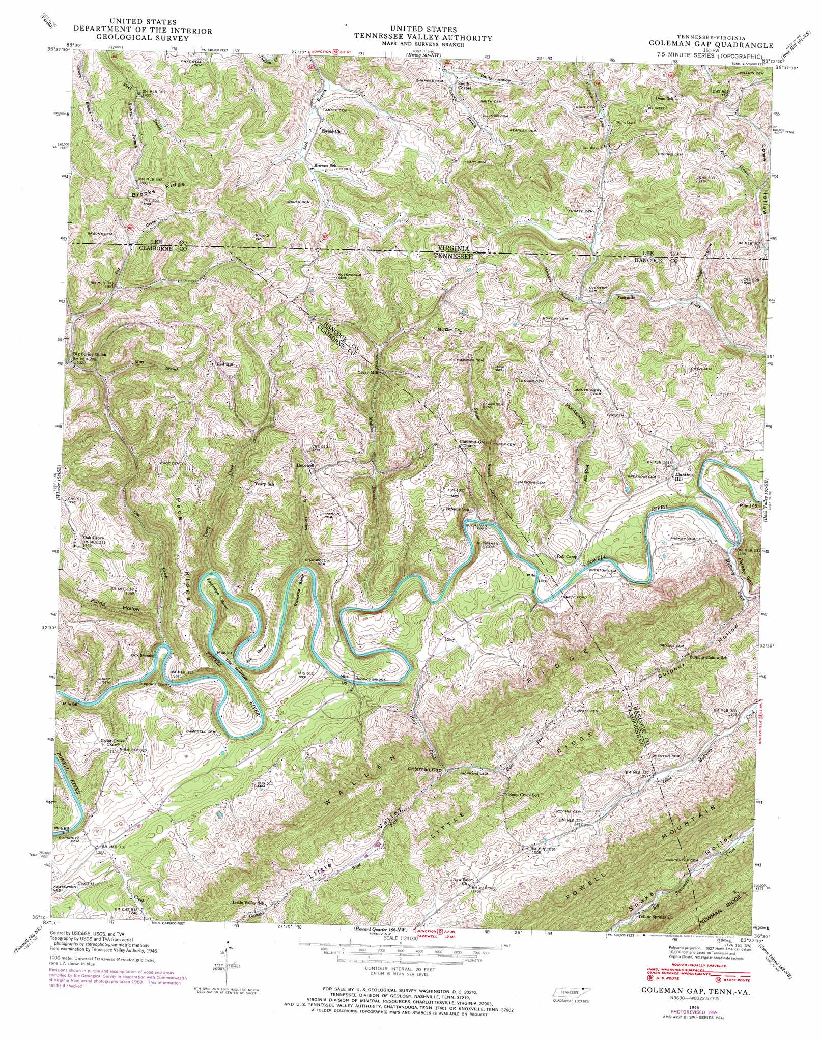
USGS Topo Quad 36083e4 - 1:24,000 scale
| Topo Map Name: | Coleman Gap |
| USGS Topo Quad ID: | 36083e4 |
| Print Size: | ca. 21 1/4" wide x 27" high |
| Southeast Coordinates: | 36.5° N latitude / 83.375° W longitude |
| Map Center Coordinates: | 36.5625° N latitude / 83.4375° W longitude |
| U.S. States: | TN, VA |
| Filename: | o36083e4.jpg |
| Download Map JPG Image: | Coleman Gap topo map 1:24,000 scale |
| Map Type: | Topographic |
| Topo Series: | 7.5´ |
| Map Scale: | 1:24,000 |
| Source of Map Images: | United States Geological Survey (USGS) |
| Alternate Map Versions: |
Colman TN 1935 Download PDF Buy paper map Colemen Gap TN 1946, updated 1970 Download PDF Buy paper map Colemen Gap TN 1950 Download PDF Buy paper map Colemen Gap TN 1976, updated 1981 Download PDF Buy paper map Coleman Gap TN 2010 Download PDF Buy paper map Coleman Gap TN 2013 Download PDF Buy paper map Coleman Gap TN 2016 Download PDF Buy paper map |
1:24,000 Topo Quads surrounding Coleman Gap
Pineville |
Balkan |
Wallins Creek |
Harlan |
Evarts |
Middlesboro North |
Varilla |
Ewing |
Rose Hill |
Hubbard Springs |
Middlesboro South |
Wheeler |
Coleman Gap |
Back Valley |
Sneedville |
Clouds |
Tazewell |
Howard Quarter |
Swan Island |
Lee Valley |
Powder Springs |
Dutch Valley |
Avondale |
Bean Station |
Russellville |
> Back to 36083e1 at 1:100,000 scale
> Back to 36082a1 at 1:250,000 scale
> Back to U.S. Topo Maps home
Coleman Gap topo map: Gazetteer
Coleman Gap: Bends
Eastridge Bend elevation 391m 1282′Elk Bend elevation 370m 1213′
Rowland Bend elevation 388m 1272′
Coleman Gap: Bridges
Brooks Bridge elevation 346m 1135′Coleman Gap: Crossings
Buchanan Ford elevation 350m 1148′Fugate Ford elevation 351m 1151′
Hurst Ford elevation 339m 1112′
Rob Camp Ford elevation 350m 1148′
Coleman Gap: Gaps
Coleman Gap elevation 392m 1286′Parkey Gap elevation 365m 1197′
The Narrows elevation 347m 1138′
Coleman Gap: Populated Places
Alanthus Hill elevation 411m 1348′Gibson Hall elevation 372m 1220′
Hoop Creek elevation 431m 1414′
Hopewell elevation 480m 1574′
Oak Grove elevation 534m 1751′
Red Hill elevation 522m 1712′
Riley elevation 370m 1213′
Yeary Mill elevation 431m 1414′
Yellow Springs elevation 397m 1302′
Coleman Gap: Rapids
Cox Shoals elevation 339m 1112′Coleman Gap: Ridges
Brooks Ridge elevation 528m 1732′Pace Ridge elevation 502m 1646′
Powell Mountain elevation 606m 1988′
Coleman Gap: Streams
Coonsies Creek elevation 373m 1223′Cox Creek elevation 340m 1115′
Cox Creek elevation 339m 1112′
East Fork Hoop Creek elevation 392m 1286′
Edd Branch elevation 419m 1374′
Hoop Creek elevation 346m 1135′
Keslerson Branch elevation 425m 1394′
Marr Branch elevation 391m 1282′
Mulberry Creek elevation 352m 1154′
Mullins Branch elevation 347m 1138′
Sutton Branch elevation 350m 1148′
West Fork Hoop Creek elevation 392m 1286′
Yeary Creek elevation 343m 1125′
Coleman Gap: Valleys
Daniel Hollow elevation 406m 1332′Dry Hollow elevation 346m 1135′
Estep Hollow elevation 409m 1341′
Estep Hollow elevation 409m 1341′
Line Hollow elevation 418m 1371′
Monday Hollow elevation 412m 1351′
Montgomery Hollow elevation 353m 1158′
Pump Hollow elevation 357m 1171′
Smith Hollow elevation 442m 1450′
Sulphur Hollow elevation 360m 1181′
Trigger Hollow elevation 384m 1259′
Trigger Hollow elevation 389m 1276′
Coleman Gap digital topo map on disk
Buy this Coleman Gap topo map showing relief, roads, GPS coordinates and other geographical features, as a high-resolution digital map file on DVD:
Western Virginia & Southern West Virginia
Buy digital topo maps: Western Virginia & Southern West Virginia