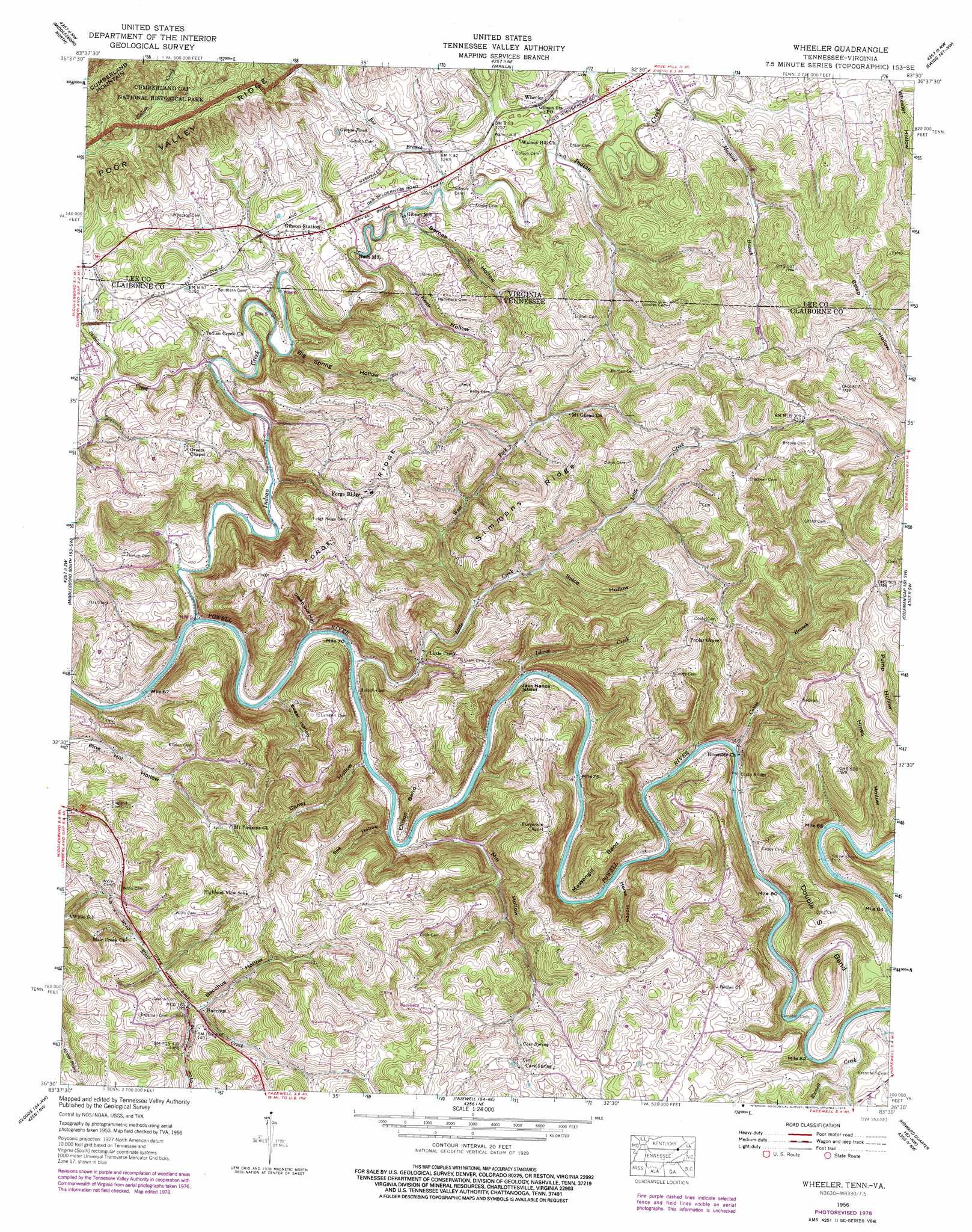
Wheeler Topo Map Tennessee
To zoom in, hover over the map of Wheeler
USGS Topo Quad 36083e5 - 1:24,000 scale
| Topo Map Name: | Wheeler |
| USGS Topo Quad ID: | 36083e5 |
| Print Size: | ca. 21 1/4" wide x 27" high |
| Southeast Coordinates: | 36.5° N latitude / 83.5° W longitude |
| Map Center Coordinates: | 36.5625° N latitude / 83.5625° W longitude |
| U.S. States: | TN, VA |
| Filename: | o36083e5.jpg |
| Download Map JPG Image: | Wheeler topo map 1:24,000 scale |
| Map Type: | Topographic |
| Topo Series: | 7.5´ |
| Map Scale: | 1:24,000 |
| Source of Map Images: | United States Geological Survey (USGS) |
| Alternate Map Versions: |
Wheeler VA 1935 Download PDF Buy paper map Wheeler VA 1956, updated 1958 Download PDF Buy paper map Wheeler VA 1956, updated 1972 Download PDF Buy paper map Wheeler VA 1956, updated 1978 Download PDF Buy paper map Wheeler VA 1976, updated 1981 Download PDF Buy paper map Wheeler VA 2010 Download PDF Buy paper map Wheeler VA 2013 Download PDF Buy paper map Wheeler VA 2016 Download PDF Buy paper map |
1:24,000 Topo Quads surrounding Wheeler
Artemus |
Pineville |
Balkan |
Wallins Creek |
Harlan |
Kayjay |
Middlesboro North |
Varilla |
Ewing |
Rose Hill |
Fork Ridge |
Middlesboro South |
Wheeler |
Coleman Gap |
Back Valley |
Ausmus |
Clouds |
Tazewell |
Howard Quarter |
Swan Island |
Maynardville |
Powder Springs |
Dutch Valley |
Avondale |
Bean Station |
> Back to 36083e1 at 1:100,000 scale
> Back to 36082a1 at 1:250,000 scale
> Back to U.S. Topo Maps home
Wheeler topo map: Gazetteer
Wheeler: Bends
Double S Bend elevation 487m 1597′Ellison Bend elevation 393m 1289′
Massengill Bend elevation 438m 1437′
Wheeler: Bridges
Cosby Bridge elevation 334m 1095′Wheeler: Crossings
Bussell Ford elevation 319m 1046′Campbell Ford elevation 332m 1089′
Cosby Ford elevation 330m 1082′
Yellow Shoals Ford elevation 339m 1112′
Wheeler: Islands
Jack Nance Island elevation 327m 1072′Wheeler: Lakes
Gibson Pond elevation 406m 1332′Wheeler: Populated Places
Bacchus elevation 390m 1279′Cave Spring elevation 463m 1519′
Forge Ridge elevation 459m 1505′
Gibson Mill elevation 371m 1217′
Gibson Station elevation 364m 1194′
Little Creek elevation 337m 1105′
Nash Mill elevation 376m 1233′
Poplar Grove elevation 535m 1755′
Riverside elevation 342m 1122′
Wheeler elevation 390m 1279′
Wheeler: Ridges
Forge Ridge elevation 455m 1492′Furgerson Ridge elevation 485m 1591′
Simmons Ridge elevation 477m 1564′
Wheeler: Springs
Cave Spring elevation 439m 1440′Wheeler: Streams
Bee Branch elevation 372m 1220′Canoe Branch elevation 330m 1082′
Cave Spring Creek elevation 325m 1066′
Cedar Fork Creek elevation 340m 1115′
Indian Creek elevation 322m 1056′
Island Creek elevation 332m 1089′
Little Creek elevation 323m 1059′
Machine Branch elevation 392m 1286′
Machine Branch elevation 396m 1299′
Pendleton Branch elevation 371m 1217′
Pines Creek elevation 340m 1115′
Russell Creek elevation 335m 1099′
Station Creek elevation 338m 1108′
Station Creek elevation 360m 1181′
West Fork Little Creek elevation 352m 1154′
Wheeler: Summits
Walnut Hill elevation 415m 1361′Wheeler: Valleys
Bacchus Hollow elevation 389m 1276′Barnes Hollow elevation 380m 1246′
Barnes Hollow elevation 374m 1227′
Bee Hollow elevation 341m 1118′
Big Spring Hollow elevation 358m 1174′
Caney Hollow elevation 329m 1079′
Cedar Fork Valley elevation 368m 1207′
Grassy Hollow elevation 454m 1489′
Hines Hollow elevation 340m 1115′
Horse Hollow elevation 335m 1099′
Keck Hollow elevation 401m 1315′
Keck Hollow elevation 363m 1190′
Mill Hollow elevation 328m 1076′
Spice Hollow elevation 382m 1253′
Steep Gut Hollow elevation 327m 1072′
Sugar Hollow elevation 327m 1072′
Wheeler digital topo map on disk
Buy this Wheeler topo map showing relief, roads, GPS coordinates and other geographical features, as a high-resolution digital map file on DVD:
Western Virginia & Southern West Virginia
Buy digital topo maps: Western Virginia & Southern West Virginia