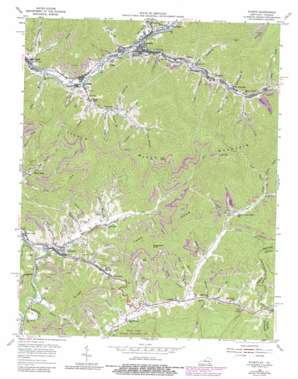
Evarts Topo Map Kentucky
To zoom in, hover over the map of Evarts
USGS Topo Quad 36083g2 - 1:24,000 scale
| Topo Map Name: | Evarts |
| USGS Topo Quad ID: | 36083g2 |
| Print Size: | ca. 21 1/4" wide x 27" high |
| Southeast Coordinates: | 36.75° N latitude / 83.125° W longitude |
| Map Center Coordinates: | 36.8125° N latitude / 83.1875° W longitude |
| U.S. States: | KY, VA |
| Filename: | o36083g2.jpg |
| Download Map JPG Image: | Evarts topo map 1:24,000 scale |
| Map Type: | Topographic |
| Topo Series: | 7.5´ |
| Map Scale: | 1:24,000 |
| Source of Map Images: | United States Geological Survey (USGS) |
| Alternate Map Versions: |
Evarts KY 1935 Download PDF Buy paper map Evarts KY 1954, updated 1955 Download PDF Buy paper map Evarts KY 1954, updated 1967 Download PDF Buy paper map Evarts KY 1954, updated 1980 Download PDF Buy paper map Evarts KY 1976, updated 1981 Download PDF Buy paper map Evarts KY 2011 Download PDF Buy paper map Evarts KY 2013 Download PDF Buy paper map Evarts KY 2016 Download PDF Buy paper map |
1:24,000 Topo Quads surrounding Evarts
> Back to 36083e1 at 1:100,000 scale
> Back to 36082a1 at 1:250,000 scale
> Back to U.S. Topo Maps home
Evarts topo map: Gazetteer
Evarts: Parks
Cranks Creek Wildlife Management Area elevation 542m 1778′Stone Mountain Park elevation 439m 1440′
Evarts: Populated Places
Ages elevation 404m 1325′Black Mountain elevation 447m 1466′
Bobs Creek elevation 386m 1266′
Brookside elevation 383m 1256′
Cawood elevation 403m 1322′
Cranks elevation 447m 1466′
Crummies elevation 463m 1519′
Darkmont elevation 399m 1309′
Draper elevation 389m 1276′
Evarts elevation 480m 1574′
Kenvir elevation 444m 1456′
Kildav elevation 414m 1358′
Redbud elevation 435m 1427′
Ten Spot elevation 411m 1348′
Verda elevation 412m 1351′
Woods elevation 406m 1332′
Evarts: Post Offices
Ages Post Office (historical) elevation 378m 1240′Bailey Post Office (historical) elevation 399m 1309′
Bobs Creek Post Office (historical) elevation 386m 1266′
Cawood Post Office (historical) elevation 385m 1263′
Cranks Post Office (historical) elevation 456m 1496′
Crummies Post Office (historical) elevation 461m 1512′
Draper Post Office (historical) elevation 399m 1309′
Keith Post Office (historical) elevation 416m 1364′
Kildav Post Office (historical) elevation 390m 1279′
Leadford Post Office (historical) elevation 463m 1519′
Redbud Post Office (historical) elevation 418m 1371′
Smithville Post Office (historical) elevation 398m 1305′
Verda Post Office (historical) elevation 412m 1351′
Evarts: Ridges
Cranks Ridge elevation 520m 1706′Crummies Spur elevation 791m 2595′
Lone Spur elevation 782m 2565′
Mill Ridge elevation 501m 1643′
Evarts: Streams
Ages Creek elevation 378m 1240′Bailey Creek elevation 409m 1341′
Barn Branch elevation 434m 1423′
Bear Branch elevation 400m 1312′
Big Branch elevation 489m 1604′
Bobs Creek elevation 388m 1272′
Bridge Branch elevation 448m 1469′
Britton Creek elevation 461m 1512′
Burgoyne Branch elevation 434m 1423′
Cawood Branch elevation 402m 1318′
Chestnut Branch elevation 522m 1712′
Crummies Creek elevation 385m 1263′
Daves Branch elevation 470m 1541′
Days Branch elevation 386m 1266′
Gabes Branch elevation 377m 1236′
Grant Branch elevation 439m 1440′
Ikes Branch elevation 450m 1476′
James Creek elevation 386m 1266′
Jerry Branch elevation 387m 1269′
Jones Creek elevation 388m 1272′
Laurel Branch elevation 429m 1407′
Laurel Branch elevation 475m 1558′
Left Fork Ages Creek elevation 398m 1305′
Left Fork Cranks Creek elevation 544m 1784′
Lick Branch elevation 385m 1263′
Little Creek elevation 429m 1407′
Long Branch elevation 391m 1282′
Lower Halls Branch elevation 427m 1400′
Lower Laurel Branch elevation 446m 1463′
Meadow Branch elevation 444m 1456′
Middle Fork Cranks Creek elevation 544m 1784′
Mill Branch elevation 435m 1427′
Mill Creek elevation 440m 1443′
Myer Branch elevation 431m 1414′
Nims Branch elevation 450m 1476′
Penny Branch elevation 436m 1430′
Pounding Mill Branch elevation 426m 1397′
Raccoon Branch elevation 388m 1272′
Reds Creek elevation 468m 1535′
Reids Branch elevation 458m 1502′
Right Fork Cranks Creek elevation 507m 1663′
Right Fork Turtle Creek elevation 423m 1387′
Road Branch elevation 426m 1397′
Schoolhouse Branch elevation 447m 1466′
Sharps Branch elevation 463m 1519′
Skidmore Branch elevation 470m 1541′
Stillhouse Branch elevation 385m 1263′
Sugarcamp Branch elevation 412m 1351′
Thompson Branch elevation 397m 1302′
Trap Branch elevation 510m 1673′
Turner Branch elevation 399m 1309′
Upper Halls Branch elevation 424m 1391′
Upper Laurel Branch elevation 450m 1476′
Yocum Creek elevation 480m 1574′
Evarts: Summits
Kitts Knob elevation 959m 3146′Sugarcamp Knob elevation 817m 2680′
Evarts: Valleys
Cutshin Hollow elevation 518m 1699′Fisher Hollow elevation 424m 1391′
Slack Hollow elevation 420m 1377′
Sulphur Spring Hollow elevation 445m 1459′
Evarts digital topo map on disk
Buy this Evarts topo map showing relief, roads, GPS coordinates and other geographical features, as a high-resolution digital map file on DVD:
Western Virginia & Southern West Virginia
Buy digital topo maps: Western Virginia & Southern West Virginia


