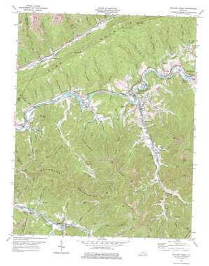
Wallins Creek Topo Map Kentucky
To zoom in, hover over the map of Wallins Creek
USGS Topo Quad 36083g4 - 1:24,000 scale
| Topo Map Name: | Wallins Creek |
| USGS Topo Quad ID: | 36083g4 |
| Print Size: | ca. 21 1/4" wide x 27" high |
| Southeast Coordinates: | 36.75° N latitude / 83.375° W longitude |
| Map Center Coordinates: | 36.8125° N latitude / 83.4375° W longitude |
| U.S. State: | KY |
| Filename: | o36083g4.jpg |
| Download Map JPG Image: | Wallins Creek topo map 1:24,000 scale |
| Map Type: | Topographic |
| Topo Series: | 7.5´ |
| Map Scale: | 1:24,000 |
| Source of Map Images: | United States Geological Survey (USGS) |
| Alternate Map Versions: |
Wallins Creek KY 1954, updated 1956 Download PDF Buy paper map Wallins Creek KY 1954, updated 1969 Download PDF Buy paper map Wallins Creek KY 1974, updated 1975 Download PDF Buy paper map Wallins Creek KY 2010 Download PDF Buy paper map Wallins Creek KY 2013 Download PDF Buy paper map Wallins Creek KY 2016 Download PDF Buy paper map |
1:24,000 Topo Quads surrounding Wallins Creek
> Back to 36083e1 at 1:100,000 scale
> Back to 36082a1 at 1:250,000 scale
> Back to U.S. Topo Maps home
Wallins Creek topo map: Gazetteer
Wallins Creek: Flats
Sloane Fields elevation 345m 1131′Wallins Creek: Gaps
Salt Trace Gap elevation 670m 2198′Wallins Creek: Populated Places
Coldiron elevation 345m 1131′Creech elevation 444m 1456′
Insull elevation 357m 1171′
Kentenia elevation 380m 1246′
Layman elevation 345m 1131′
Longton elevation 347m 1138′
Molus elevation 340m 1115′
Pathfork elevation 378m 1240′
South Wallins elevation 348m 1141′
Tacky Town elevation 364m 1194′
Tremont elevation 359m 1177′
Twila elevation 423m 1387′
Wallins Creek elevation 346m 1135′
Wilhoit elevation 353m 1158′
Wallins Creek: Post Offices
Cargo Post Office (historical) elevation 345m 1131′Day Post Office (historical) elevation 351m 1151′
Dayhoit Post Office elevation 353m 1158′
Gross Post Office (historical) elevation 383m 1256′
Insull Post Office (historical) elevation 355m 1164′
Kentenia Post Office (historical) elevation 376m 1233′
Layman Post Office (historical) elevation 344m 1128′
Lisle Post Office (historical) elevation 403m 1322′
Molus Post Office (historical) elevation 340m 1115′
Pass Post Office (historical) elevation 348m 1141′
Salts Post Office (historical) elevation 524m 1719′
Tremont Post Office (historical) elevation 392m 1286′
Twila Post Office (historical) elevation 425m 1394′
Wallins Creek Post Office (historical) elevation 350m 1148′
Wallins Creek: Ridges
Foresters Spur elevation 796m 2611′Jesse Spur elevation 649m 2129′
Puckett Ridge elevation 963m 3159′
Toms Spur elevation 869m 2851′
Wallins Creek: Streams
Adams Branch elevation 460m 1509′Banner Fork elevation 412m 1351′
Ben Saylor Branch elevation 351m 1151′
Big Branch elevation 339m 1112′
Big Branch elevation 389m 1276′
Big Run elevation 354m 1161′
Blanton Branch elevation 413m 1354′
Brock Branch elevation 386m 1266′
Brock Branch elevation 351m 1151′
Camp Branch elevation 365m 1197′
Cliff Branch elevation 338m 1108′
Cox Branch elevation 349m 1145′
Drakes Branch elevation 340m 1115′
Elisha Howard Branch elevation 336m 1102′
Flat Branch elevation 376m 1233′
Foresters Creek elevation 334m 1095′
Ginseng Creek elevation 401m 1315′
Hensley Branch elevation 329m 1079′
High Fork Branch elevation 401m 1315′
Hobbs Fork elevation 385m 1263′
Jackson Mill Creek elevation 394m 1292′
Jesses Creek elevation 338m 1108′
Laurel Branch elevation 343m 1125′
Laurel Branch elevation 337m 1105′
Laurel Branch elevation 362m 1187′
Lee Ann Branch elevation 384m 1259′
Lick Branch elevation 402m 1318′
Little Creek elevation 340m 1115′
Little Laurel Branch elevation 370m 1213′
Little Widow Branch elevation 394m 1292′
Meadow Creek elevation 372m 1220′
Mile Branch elevation 339m 1112′
Mill Creek elevation 364m 1194′
Path Fork elevation 372m 1220′
Pearl Branch elevation 341m 1118′
Pearl Saylor Branch elevation 377m 1236′
Peters Branch elevation 390m 1279′
Plats Fork elevation 354m 1161′
Rob Blanton Branch elevation 345m 1131′
Rocky Branch elevation 353m 1158′
Sally Williams Branch elevation 329m 1079′
Salt Trace Branch elevation 367m 1204′
Saylor Branch elevation 380m 1246′
Saylor Creek elevation 341m 1118′
Second Branch elevation 329m 1079′
Sugarcamp Branch elevation 465m 1525′
Sycamore Branch elevation 452m 1482′
Terry Fork elevation 341m 1118′
Trace Fork elevation 412m 1351′
Wallins Creek elevation 338m 1108′
Watts Creek elevation 346m 1135′
Wax Branch elevation 384m 1259′
Widow Branch elevation 376m 1233′
Wallins Creek: Summits
Bob Lowe Knob elevation 639m 2096′Fox Knob elevation 997m 3270′
Gross Knob elevation 832m 2729′
Happy Top elevation 497m 1630′
Reynolds Mountain elevation 952m 3123′
Terry Spur elevation 554m 1817′
Wallins Creek: Valleys
Bulldog Hollow elevation 364m 1194′Mapple Hollow elevation 364m 1194′
Wallins Creek digital topo map on disk
Buy this Wallins Creek topo map showing relief, roads, GPS coordinates and other geographical features, as a high-resolution digital map file on DVD:
Western Virginia & Southern West Virginia
Buy digital topo maps: Western Virginia & Southern West Virginia


