Barbourville Topo Map Kentucky
To zoom in, hover over the map of Barbourville
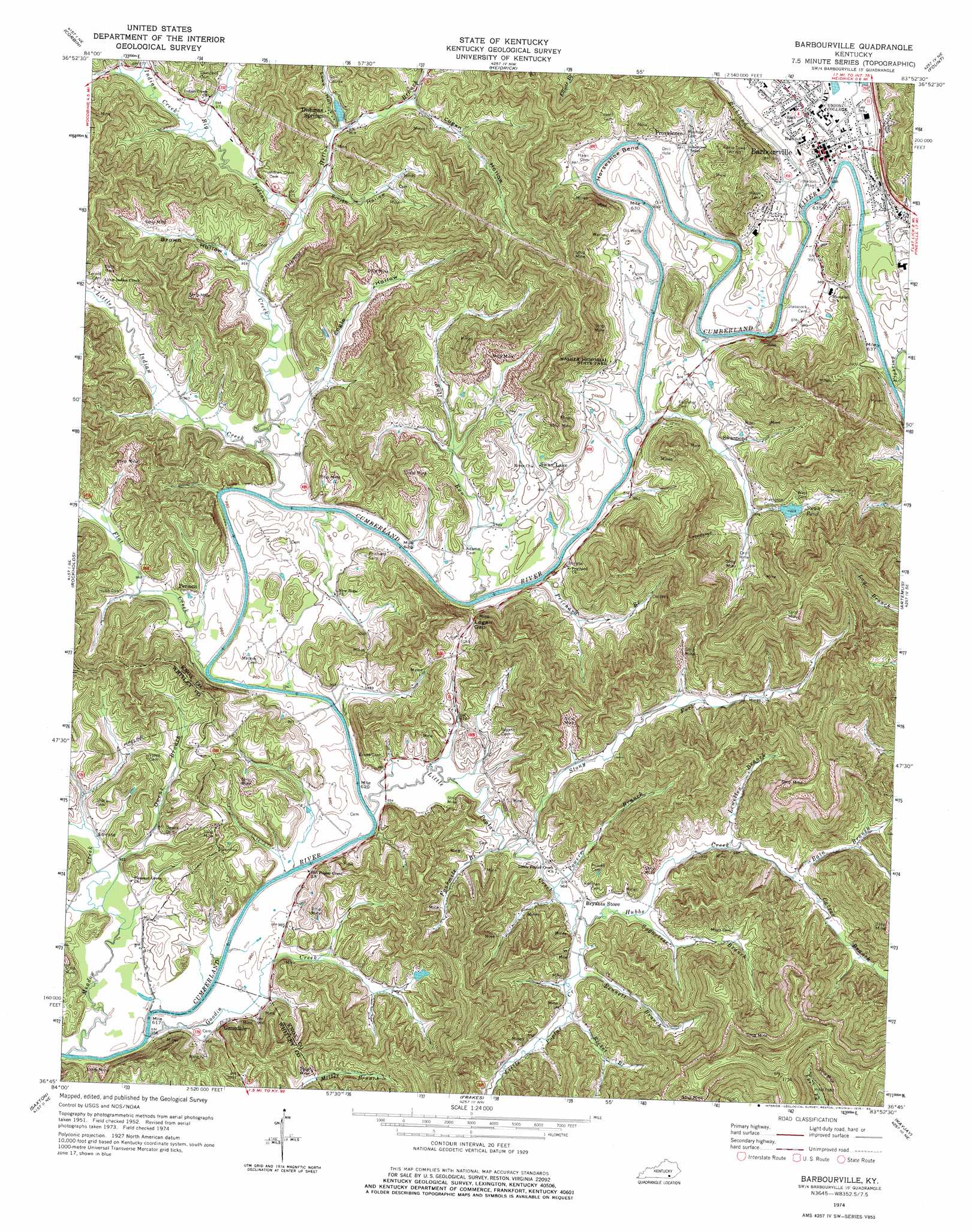
USGS Topo Quad 36083g8 - 1:24,000 scale
| Topo Map Name: | Barbourville |
| USGS Topo Quad ID: | 36083g8 |
| Print Size: | ca. 21 1/4" wide x 27" high |
| Southeast Coordinates: | 36.75° N latitude / 83.875° W longitude |
| Map Center Coordinates: | 36.8125° N latitude / 83.9375° W longitude |
| U.S. State: | KY |
| Filename: | o36083g8.jpg |
| Download Map JPG Image: | Barbourville topo map 1:24,000 scale |
| Map Type: | Topographic |
| Topo Series: | 7.5´ |
| Map Scale: | 1:24,000 |
| Source of Map Images: | United States Geological Survey (USGS) |
| Alternate Map Versions: |
Barbourville KY 1952, updated 1953 Download PDF Buy paper map Barbourville KY 1952, updated 1968 Download PDF Buy paper map Barbourville KY 1974, updated 1975 Download PDF Buy paper map Barbourville KY 2010 Download PDF Buy paper map Barbourville KY 2013 Download PDF Buy paper map Barbourville KY 2016 Download PDF Buy paper map |
1:24,000 Topo Quads surrounding Barbourville
London Sw |
Lily |
Blackwater |
Hima |
Ogle |
Vox |
Corbin |
Heidrick |
Fount |
Scalf |
Wofford |
Rockholds |
Barbourville |
Artemus |
Pineville |
Williamsburg |
Saxton |
Frakes |
Kayjay |
Middlesboro North |
Jellico West |
Jellico East |
Eagan |
Fork Ridge |
Middlesboro South |
> Back to 36083e1 at 1:100,000 scale
> Back to 36082a1 at 1:250,000 scale
> Back to U.S. Topo Maps home
Barbourville topo map: Gazetteer
Barbourville: Bends
Mackey Bend elevation 292m 958′Barbourville: Gaps
Logan Gap elevation 326m 1069′Mossy Gap elevation 323m 1059′
Barbourville: Lakes
Dishman Springs Lake elevation 297m 974′Swan Pond elevation 312m 1023′
Barbourville: Parks
Walker Memorial State Park elevation 302m 990′Barbourville: Populated Places
Apple Grove elevation 298m 977′Barbourville elevation 299m 980′
Dishman Springs elevation 309m 1013′
Gausdale elevation 300m 984′
Permon elevation 305m 1000′
Providence elevation 299m 980′
Swan Lake elevation 305m 1000′
Swanpond elevation 298m 977′
Barbourville: Post Offices
Barbourville Post Office elevation 299m 980′Bryants Store Post Office elevation 294m 964′
Clate Post Office (historical) elevation 292m 958′
Dishman Post Office (historical) elevation 318m 1043′
Hubbs Post Office (historical) elevation 308m 1010′
Indian Creek Post Office (historical) elevation 297m 974′
King Post Office (historical) elevation 302m 990′
Lindsay Post Office (historical) elevation 298m 977′
Permon Post Office (historical) elevation 300m 984′
Pine Post Office (historical) elevation 306m 1003′
Swan Lake Post Office (historical) elevation 304m 997′
Swanpond Post Office (historical) elevation 293m 961′
Barbourville: Streams
Bain Branch elevation 318m 1043′Bennett Branch elevation 296m 971′
Big Indian Creek elevation 286m 938′
Bull Run elevation 286m 938′
Catron Branch elevation 318m 1043′
Fighting Creek elevation 292m 958′
Flat Creek elevation 288m 944′
Fourmile Branch elevation 291m 954′
Goodin Creek elevation 286m 938′
Helton Branch elevation 291m 954′
Hubbs Creek elevation 293m 961′
Indian Creek elevation 294m 964′
Lewellen Branch elevation 298m 977′
Little Indian Creek elevation 286m 938′
Little Poplar Creek elevation 286m 938′
Meadow Creek elevation 286m 938′
Owens Branch elevation 288m 944′
Powers Branch elevation 290m 951′
Prichard Branch elevation 293m 961′
Richland Creek elevation 290m 951′
Ricket Branch elevation 296m 971′
Smokey Creek elevation 306m 1003′
Stony Fork elevation 292m 958′
Sugartree Branch elevation 293m 961′
Swan Pond Creek elevation 283m 928′
Barbourville: Valleys
Brown Hollow elevation 291m 954′Engle Hollow elevation 292m 958′
Logan Hollow elevation 309m 1013′
Low Hollow elevation 328m 1076′
Lowe Hollow elevation 297m 974′
Punch Hollow elevation 296m 971′
Smith Hollow elevation 295m 967′
Barbourville digital topo map on disk
Buy this Barbourville topo map showing relief, roads, GPS coordinates and other geographical features, as a high-resolution digital map file on DVD:
Western Virginia & Southern West Virginia
Buy digital topo maps: Western Virginia & Southern West Virginia