Beverly Topo Map Kentucky
To zoom in, hover over the map of Beverly
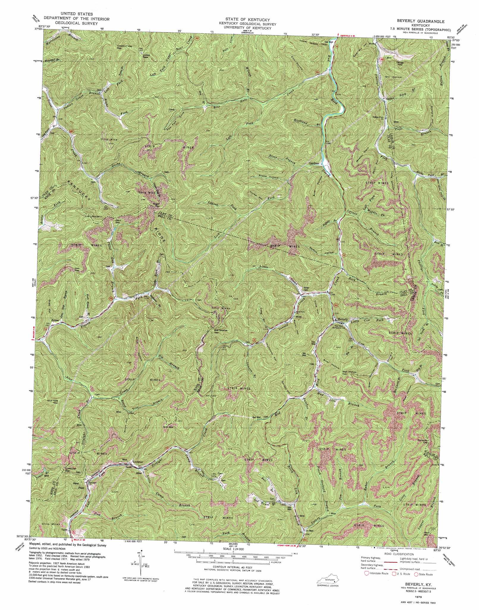
USGS Topo Quad 36083h5 - 1:24,000 scale
| Topo Map Name: | Beverly |
| USGS Topo Quad ID: | 36083h5 |
| Print Size: | ca. 21 1/4" wide x 27" high |
| Southeast Coordinates: | 36.875° N latitude / 83.5° W longitude |
| Map Center Coordinates: | 36.9375° N latitude / 83.5625° W longitude |
| U.S. State: | KY |
| Filename: | o36083h5.jpg |
| Download Map JPG Image: | Beverly topo map 1:24,000 scale |
| Map Type: | Topographic |
| Topo Series: | 7.5´ |
| Map Scale: | 1:24,000 |
| Source of Map Images: | United States Geological Survey (USGS) |
| Alternate Map Versions: |
Beverly KY 1954, updated 1956 Download PDF Buy paper map Beverly KY 1954, updated 1967 Download PDF Buy paper map Beverly KY 1979, updated 1979 Download PDF Buy paper map Beverly KY 2011 Download PDF Buy paper map Beverly KY 2013 Download PDF Buy paper map Beverly KY 2016 Download PDF Buy paper map |
| FStopo: | US Forest Service topo Beverly is available: Download FStopo PDF Download FStopo TIF |
1:24,000 Topo Quads surrounding Beverly
Manchester |
Barcreek |
Big Creek |
Hyden West |
Hyden East |
Hima |
Ogle |
Creekville |
Hoskinston |
Cutshin |
Fount |
Scalf |
Beverly |
Helton |
Bledsoe |
Artemus |
Pineville |
Balkan |
Wallins Creek |
Harlan |
Kayjay |
Middlesboro North |
Varilla |
Ewing |
Rose Hill |
> Back to 36083e1 at 1:100,000 scale
> Back to 36082a1 at 1:250,000 scale
> Back to U.S. Topo Maps home
Beverly topo map: Gazetteer
Beverly: Gaps
Bear Wallow Gap elevation 624m 2047′Bob Slusher Gap elevation 590m 1935′
Chestnut Log Gap elevation 518m 1699′
Kentucky Gap elevation 684m 2244′
Low Gap elevation 553m 1814′
Mud Gap elevation 646m 2119′
Mud Hole Gap elevation 571m 1873′
Paint Gap elevation 511m 1676′
Sugar Gap elevation 612m 2007′
Turkeypen Gap elevation 508m 1666′
Beverly: Populated Places
Beverly elevation 389m 1276′Erose elevation 361m 1184′
Field elevation 407m 1335′
Gardner elevation 346m 1135′
Beverly: Post Offices
Eros Post Office (historical) elevation 488m 1601′Gardner Post Office (historical) elevation 341m 1118′
Ice Cliff Post Office (historical) elevation 418m 1371′
Sand Fork Post Office (historical) elevation 468m 1535′
Skidmore Post Office (historical) elevation 312m 1023′
Beverly: Ridges
Kentucky Ridge elevation 589m 1932′Beverly: Streams
Alex Creek elevation 354m 1161′Baker Branch elevation 453m 1486′
Bell Branch elevation 465m 1525′
Ben Carrol Branch elevation 445m 1459′
Big Branch elevation 404m 1325′
Big Branch elevation 442m 1450′
Birch Lick Branch elevation 407m 1335′
Bloss Branch elevation 352m 1154′
Blue Hole Creek elevation 321m 1053′
Board Tree Branch elevation 447m 1466′
Buffalo Branch elevation 360m 1181′
Butcher Branch elevation 425m 1394′
Camp Branch elevation 453m 1486′
Carter Roark Branch elevation 418m 1371′
Coon Branch elevation 480m 1574′
Cow Branch elevation 383m 1256′
Cow Fork elevation 389m 1276′
Darbs Branch elevation 376m 1233′
Dry Branch elevation 401m 1315′
Dry Branch elevation 452m 1482′
East Branch Phillips Fork elevation 445m 1459′
Indian Grave Branch elevation 339m 1112′
Jackson Branch elevation 400m 1312′
Jim Branch elevation 437m 1433′
Laurel Branch elevation 542m 1778′
Laurel Fork elevation 408m 1338′
Lawson Branch elevation 435m 1427′
Lawson Creek elevation 379m 1243′
Left Fork Blue Hole Creek elevation 357m 1171′
Left Fork Indian Grave Branch elevation 390m 1279′
Left Fork Spruce Branch elevation 377m 1236′
Lick Fork elevation 334m 1095′
Little Camp Branch elevation 418m 1371′
Little Cow Fork elevation 393m 1289′
Little Creek elevation 388m 1272′
Little Rocky Point Branch elevation 391m 1282′
Long Branch elevation 418m 1371′
Low Gap Branch elevation 365m 1197′
Middle Fork Spruce Branch elevation 377m 1236′
Mud Lick Branch elevation 419m 1374′
Old Field Branch elevation 340m 1115′
Old House Branch elevation 443m 1453′
Paint Gap Branch elevation 386m 1266′
Paw Paw Cove elevation 442m 1450′
Peach Orchard Branch elevation 428m 1404′
Pigeon Fork elevation 354m 1161′
Pups Branch elevation 347m 1138′
Rich Branch elevation 373m 1223′
Richland Branch elevation 325m 1066′
Right Fork Indian Grave Branch elevation 390m 1279′
Rock House Branch elevation 369m 1210′
Rocky Point Branch elevation 372m 1220′
Sal North Branch elevation 478m 1568′
Sandy Fork elevation 466m 1528′
Spice Lick Branch elevation 346m 1135′
Spruce Branch elevation 355m 1164′
Steel Trap Branch elevation 322m 1056′
Straight Creek elevation 399m 1309′
Straight Creek Branch elevation 397m 1302′
Sugar Gap Branch elevation 432m 1417′
Toms Branch elevation 420m 1377′
Wilson Branch elevation 369m 1210′
Beverly: Trails
The Wetherby Trail elevation 446m 1463′Beverly: Valleys
Bear Wallow Hollow elevation 436m 1430′Briar Hollow elevation 426m 1397′
Briar Hollow elevation 344m 1128′
Buck Hollow elevation 445m 1459′
Cove Hollow elevation 407m 1335′
Cow Hollow elevation 355m 1164′
Garden Hollow elevation 436m 1430′
Horse Hollow elevation 406m 1332′
Long Hollow elevation 376m 1233′
McRoe Hollow elevation 375m 1230′
Mill Hollow elevation 361m 1184′
Mosley Cove elevation 373m 1223′
Neal Hollow elevation 474m 1555′
Orchard Hollow elevation 447m 1466′
Orchard Hollow elevation 409m 1341′
Rocky Hollow elevation 411m 1348′
Saw Pit Hollow elevation 324m 1062′
Shep Hollow elevation 380m 1246′
Short Hollow elevation 379m 1243′
Snake Hollow elevation 372m 1220′
Thompson Hollow elevation 437m 1433′
Upper DeZarn Hollow elevation 335m 1099′
Witch Hollow elevation 426m 1397′
Beverly digital topo map on disk
Buy this Beverly topo map showing relief, roads, GPS coordinates and other geographical features, as a high-resolution digital map file on DVD:
Western Virginia & Southern West Virginia
Buy digital topo maps: Western Virginia & Southern West Virginia