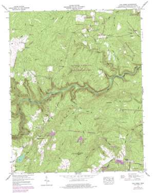
Fox Creek Topo Map Tennessee
To zoom in, hover over the map of Fox Creek
USGS Topo Quad 36084a8 - 1:24,000 scale
| Topo Map Name: | Fox Creek |
| USGS Topo Quad ID: | 36084a8 |
| Print Size: | ca. 21 1/4" wide x 27" high |
| Southeast Coordinates: | 36° N latitude / 84.875° W longitude |
| Map Center Coordinates: | 36.0625° N latitude / 84.9375° W longitude |
| U.S. State: | TN |
| Filename: | o36084a8.jpg |
| Download Map JPG Image: | Fox Creek topo map 1:24,000 scale |
| Map Type: | Topographic |
| Topo Series: | 7.5´ |
| Map Scale: | 1:24,000 |
| Source of Map Images: | United States Geological Survey (USGS) |
| Alternate Map Versions: |
Fox Creek TN 1936 Download PDF Buy paper map Fox Creek TN 1946, updated 1968 Download PDF Buy paper map Fox Creek TN 1946, updated 1975 Download PDF Buy paper map Fox Creek TN 1946, updated 1976 Download PDF Buy paper map Fox Creek TN 1949 Download PDF Buy paper map Fox Creek TN 2010 Download PDF Buy paper map Fox Creek TN 2013 Download PDF Buy paper map Fox Creek TN 2016 Download PDF Buy paper map |
1:24,000 Topo Quads surrounding Fox Creek
> Back to 36084a1 at 1:100,000 scale
> Back to 36084a1 at 1:250,000 scale
> Back to U.S. Topo Maps home
Fox Creek topo map: Gazetteer
Fox Creek: Bridges
Adams Bridge elevation 419m 1374′Fox Creek: Crossings
Henry Ford elevation 397m 1302′Potter Ford elevation 403m 1322′
Fox Creek: Dams
Catherine Lake Dam elevation 595m 1952′Fox Creek Lake Dam elevation 565m 1853′
Frances Lake Dam elevation 540m 1771′
Good Neighbor Lake Dam elevation 556m 1824′
Linger Lake Dam elevation 536m 1758′
Fox Creek: Populated Places
Alpine Acres elevation 524m 1719′Catoosa Canyon elevation 526m 1725′
Catoosa Country elevation 533m 1748′
Druid Hills elevation 613m 2011′
Fairfield Glade elevation 636m 2086′
Forest Hill (historical) elevation 546m 1791′
Genesis elevation 514m 1686′
Linger Lake elevation 548m 1797′
Mill Creek (historical) elevation 542m 1778′
Peavine elevation 561m 1840′
Slate Springs elevation 576m 1889′
Wiltshire elevation 575m 1886′
Woodlands elevation 572m 1876′
Fox Creek: Post Offices
Fairfield Glade Post Office elevation 616m 2020′Fox Creek: Reservoirs
Catherine Lake elevation 595m 1952′Fox Creek Lake elevation 565m 1853′
Frances Lake elevation 540m 1771′
Good Neighbor Lake elevation 556m 1824′
Linger Lake elevation 536m 1758′
Ryan Lake elevation 588m 1929′
Fox Creek: Ridges
Bee Ridge elevation 556m 1824′Cove Ridge elevation 548m 1797′
Fox Creek: Springs
Derrick Spring elevation 487m 1597′Fox Creek: Streams
Adams Creek elevation 422m 1384′Bee Branch elevation 504m 1653′
Bob Branch elevation 436m 1430′
Cindy Creek elevation 423m 1387′
Dogleg Branch elevation 481m 1578′
Elmore Branch elevation 407m 1335′
Elmore Creek elevation 401m 1315′
Flatrock Branch elevation 397m 1302′
Fox Creek elevation 416m 1364′
Hanby Branch elevation 497m 1630′
Laurel Branch elevation 418m 1371′
Lavender Branch elevation 493m 1617′
Long Branch elevation 497m 1630′
North Fork Elmore Creek elevation 465m 1525′
Piney Branch elevation 440m 1443′
Rough Mountain Branch elevation 496m 1627′
Scantling Branch elevation 509m 1669′
Scott Creek elevation 422m 1384′
Shoal Creek elevation 420m 1377′
South Fork Elmore Creek elevation 465m 1525′
Sugarcamp Branch elevation 416m 1364′
Three Fork elevation 480m 1574′
Underwood Branch elevation 401m 1315′
Whitepine Branch elevation 529m 1735′
Wolfpen Branch elevation 461m 1512′
Fox Creek: Summits
Lavender Knob elevation 594m 1948′Pilot Knob elevation 618m 2027′
Turkey Knob elevation 617m 2024′
Fox Creek: Valleys
Babcock Hollow elevation 440m 1443′Fox Creek digital topo map on disk
Buy this Fox Creek topo map showing relief, roads, GPS coordinates and other geographical features, as a high-resolution digital map file on DVD:


