Sharp Place Topo Map Tennessee
To zoom in, hover over the map of Sharp Place
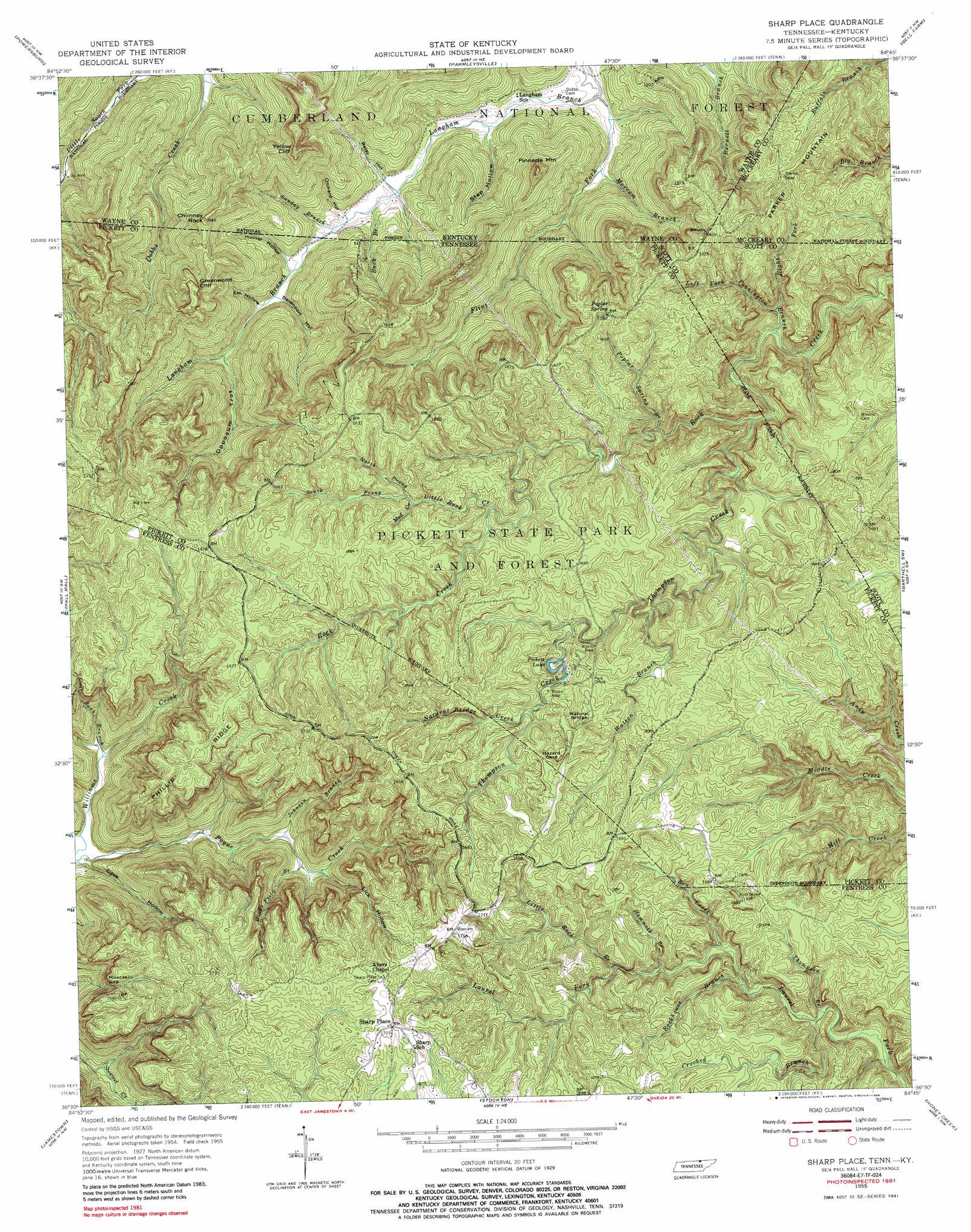
USGS Topo Quad 36084e7 - 1:24,000 scale
| Topo Map Name: | Sharp Place |
| USGS Topo Quad ID: | 36084e7 |
| Print Size: | ca. 21 1/4" wide x 27" high |
| Southeast Coordinates: | 36.5° N latitude / 84.75° W longitude |
| Map Center Coordinates: | 36.5625° N latitude / 84.8125° W longitude |
| U.S. States: | TN, KY |
| Filename: | o36084e7.jpg |
| Download Map JPG Image: | Sharp Place topo map 1:24,000 scale |
| Map Type: | Topographic |
| Topo Series: | 7.5´ |
| Map Scale: | 1:24,000 |
| Source of Map Images: | United States Geological Survey (USGS) |
| Alternate Map Versions: |
Sharp Place TN 1955, updated 1956 Download PDF Buy paper map Sharp Place TN 1955, updated 1967 Download PDF Buy paper map Sharp Place TN 1955, updated 1976 Download PDF Buy paper map Sharp Place TN 1955, updated 1989 Download PDF Buy paper map Sharp Place TN 1955, updated 1989 Download PDF Buy paper map Sharp Place TN 2000, updated 2001 Download PDF Buy paper map Sharp Place TN 2010 Download PDF Buy paper map Sharp Place TN 2013 Download PDF Buy paper map Sharp Place TN 2016 Download PDF Buy paper map |
| FStopo: | US Forest Service topo Sharp Place is available: Download FStopo PDF Download FStopo TIF |
1:24,000 Topo Quads surrounding Sharp Place
Cumberland City |
Parnell |
Monticello |
Coopersville |
Nevelsville |
Savage |
Powersburg |
Parmleysville |
Bell Farm |
Barthell |
Moodyville |
Pall Mall |
Sharp Place |
Barthell Sw |
Oneida North |
Riverton |
Jamestown |
Stockton |
Honey Creek |
Oneida South |
Wilder |
Grimsley |
Burrville |
Rugby |
Robbins |
> Back to 36084e1 at 1:100,000 scale
> Back to 36084a1 at 1:250,000 scale
> Back to U.S. Topo Maps home
Sharp Place topo map: Gazetteer
Sharp Place: Areas
The Pine Field elevation 386m 1266′Sharp Place: Cliffs
Greenwood Cliff elevation 464m 1522′Yellow Cliff elevation 500m 1640′
Sharp Place: Gaps
Moccasin Gap elevation 462m 1515′Sharp Place: Lakes
Pickett Lake elevation 455m 1492′Sharp Place: Parks
Pickett State Park and Forest elevation 470m 1541′Pickett State Rustic Park Historic District elevation 479m 1571′
Sharp Place: Pillars
Samson Hammer elevation 342m 1122′Sharp Place: Populated Places
Sharp Place elevation 520m 1706′Sharp Place: Ridges
Fork Ridge elevation 416m 1364′Phillip Ridge elevation 516m 1692′
Sharp Place: Springs
Poplar Spring elevation 485m 1591′Sharp Place: Streams
Ben Creek elevation 408m 1338′Buck Branch elevation 286m 938′
Coal Bank Branch elevation 476m 1561′
Crooked Branch elevation 387m 1269′
Dabney Branch elevation 308m 1010′
Flint Fork elevation 273m 895′
Hammock Branch elevation 421m 1381′
Hinds Field Branch elevation 335m 1099′
Johnson Branch elevation 329m 1079′
Left Fork Pennington Branch elevation 355m 1164′
Little Rock Branch elevation 433m 1420′
Little Rock Creek elevation 447m 1466′
Marcum Branch elevation 298m 977′
Mud Creek elevation 452m 1482′
Natural Bridge Creek elevation 458m 1502′
North Prong Little Rock Creek elevation 452m 1482′
Poplar Spring Branch elevation 388m 1272′
Right Fork Pennington Branch elevation 387m 1269′
Right Fork Pennington Branch elevation 365m 1197′
Rockhouse Branch elevation 401m 1315′
South Prong Little Rock Creek elevation 452m 1482′
Sunday Branch elevation 294m 964′
Thompson Branch elevation 386m 1266′
Thompson Creek elevation 384m 1259′
Watson Branch elevation 432m 1417′
Sharp Place: Summits
Chimney Rock elevation 448m 1469′Parker Mountain elevation 474m 1555′
Pinnacle Mountain elevation 416m 1364′
Sharp Place: Trails
Hidden Passage Trail elevation 453m 1486′Island Trail elevation 461m 1512′
Ladder Trail elevation 467m 1532′
Lake Bluff Trail elevation 488m 1601′
Lake View Trail elevation 464m 1522′
Ridge Trail elevation 460m 1509′
Sharp Place: Valleys
Bearpen Rough elevation 411m 1348′Betsy Hollow elevation 285m 935′
Cave Hollow elevation 289m 948′
Davenport Hollow elevation 303m 994′
Em Hollow elevation 311m 1020′
Hoover Hollow elevation 298m 977′
Lick Hollow elevation 341m 1118′
Opossum Trot elevation 317m 1040′
Orchard Hollow elevation 290m 951′
Step Hollow elevation 305m 1000′
Sharp Place digital topo map on disk
Buy this Sharp Place topo map showing relief, roads, GPS coordinates and other geographical features, as a high-resolution digital map file on DVD: