Saxton Topo Map Kentucky
To zoom in, hover over the map of Saxton
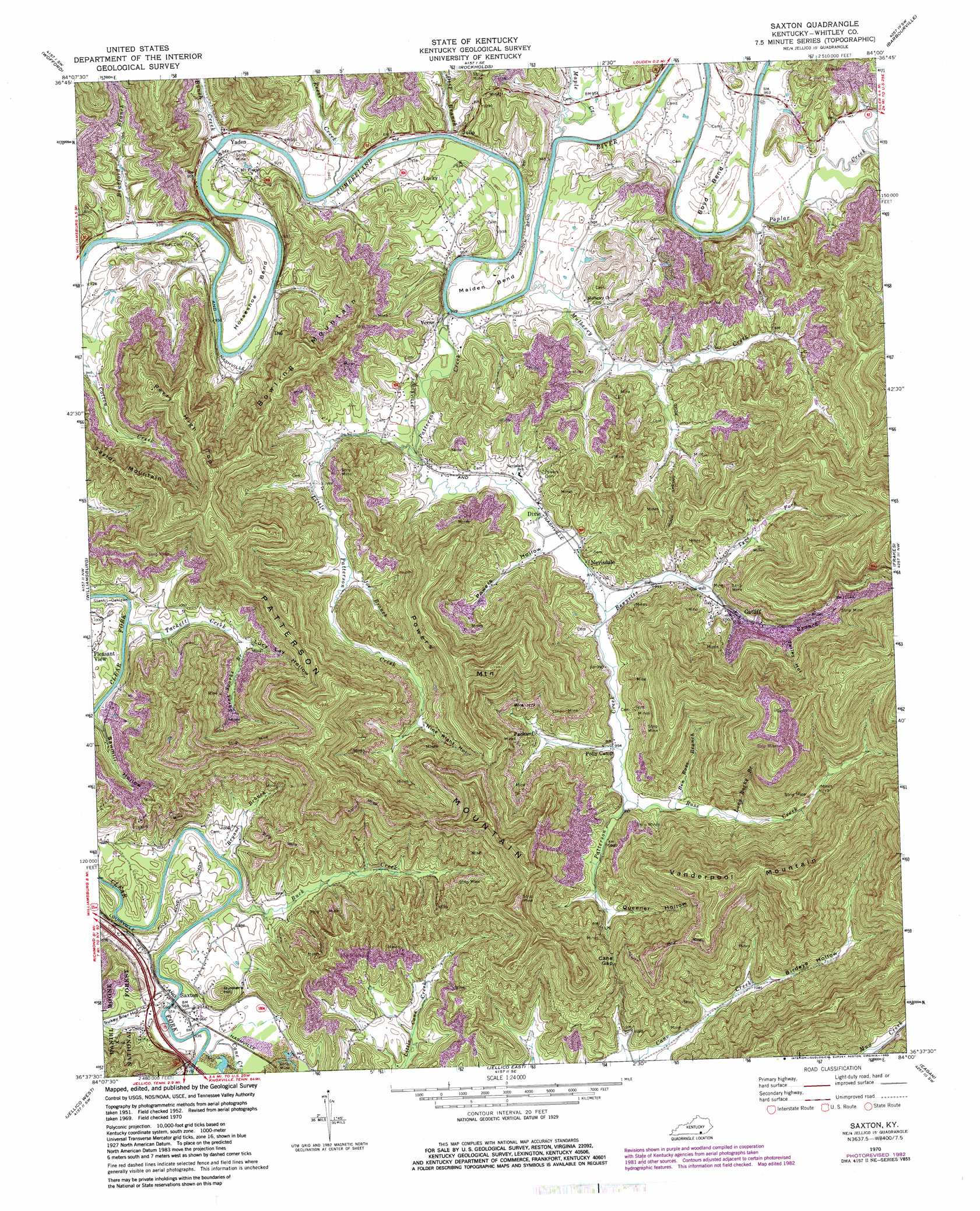
USGS Topo Quad 36084f1 - 1:24,000 scale
| Topo Map Name: | Saxton |
| USGS Topo Quad ID: | 36084f1 |
| Print Size: | ca. 21 1/4" wide x 27" high |
| Southeast Coordinates: | 36.625° N latitude / 84° W longitude |
| Map Center Coordinates: | 36.6875° N latitude / 84.0625° W longitude |
| U.S. State: | KY |
| Filename: | o36084f1.jpg |
| Download Map JPG Image: | Saxton topo map 1:24,000 scale |
| Map Type: | Topographic |
| Topo Series: | 7.5´ |
| Map Scale: | 1:24,000 |
| Source of Map Images: | United States Geological Survey (USGS) |
| Alternate Map Versions: |
Saxton KY 1952, updated 1954 Download PDF Buy paper map Saxton KY 1970, updated 1972 Download PDF Buy paper map Saxton KY 1970, updated 1983 Download PDF Buy paper map Saxton KY 2011 Download PDF Buy paper map Saxton KY 2013 Download PDF Buy paper map Saxton KY 2016 Download PDF Buy paper map |
| FStopo: | US Forest Service topo Saxton is available: Download FStopo PDF Download FStopo TIF |
1:24,000 Topo Quads surrounding Saxton
Sawyer |
Vox |
Corbin |
Heidrick |
Fount |
Cumberland Falls |
Wofford |
Rockholds |
Barbourville |
Artemus |
Hollyhill |
Williamsburg |
Saxton |
Frakes |
Kayjay |
Ketchen |
Jellico West |
Jellico East |
Eagan |
Fork Ridge |
Pioneer |
Ivydell |
La Follette |
Well Spring |
Ausmus |
> Back to 36084e1 at 1:100,000 scale
> Back to 36084a1 at 1:250,000 scale
> Back to U.S. Topo Maps home
Saxton topo map: Gazetteer
Saxton: Bends
Boyd Bend elevation 293m 961′Horseshoe Bend elevation 299m 980′
Maiden Bend elevation 293m 961′
Saxton: Gaps
Cane Gap elevation 400m 1312′Saxton: Populated Places
Dal elevation 294m 964′Dixie elevation 298m 977′
Gatliff elevation 305m 1000′
Julip elevation 299m 980′
Lucky elevation 299m 980′
Nevisdale elevation 298m 977′
Packard elevation 328m 1076′
Saxton elevation 293m 961′
Verne elevation 296m 971′
Yaden elevation 289m 948′
Saxton: Streams
Ben Rose Branch elevation 306m 1003′Bennetts Branch elevation 295m 967′
Bradford Branch elevation 281m 921′
Bryant Branch elevation 287m 941′
Buck Creek elevation 285m 935′
Bunch Creek elevation 287m 941′
Cane Creek elevation 287m 941′
Deep Branch elevation 286m 938′
Joe Branch elevation 301m 987′
Little Patterson Creek elevation 286m 938′
Long Rocky Branch elevation 318m 1043′
Maple Creek elevation 286m 938′
Mulberry Creek elevation 279m 915′
Patterson Creek elevation 279m 915′
Poplar Creek elevation 278m 912′
Reese Creek elevation 284m 931′
Rose Creek elevation 303m 994′
Sarah Sparks Branch elevation 305m 1000′
Tackett Creek elevation 281m 921′
Tyes Fork elevation 302m 990′
Saxton: Summits
Bowling Mountain elevation 499m 1637′Bunkers Hill elevation 358m 1174′
Patterson Mountain elevation 579m 1899′
Perry High Top elevation 501m 1643′
Powers Mountain elevation 599m 1965′
Taylor Mountain elevation 513m 1683′
Vanderpool Mountain elevation 636m 2086′
Saxton: Valleys
Birdeye Hollow elevation 315m 1033′Lucy Lay Hollow elevation 310m 1017′
Nine Right Hollow elevation 327m 1072′
Powers Hollow elevation 293m 961′
Queener Hollow elevation 326m 1069′
Sawmill Hollow elevation 287m 941′
Sukey Siler Hollow elevation 294m 964′
Talley Hollow elevation 319m 1046′
Saxton digital topo map on disk
Buy this Saxton topo map showing relief, roads, GPS coordinates and other geographical features, as a high-resolution digital map file on DVD: