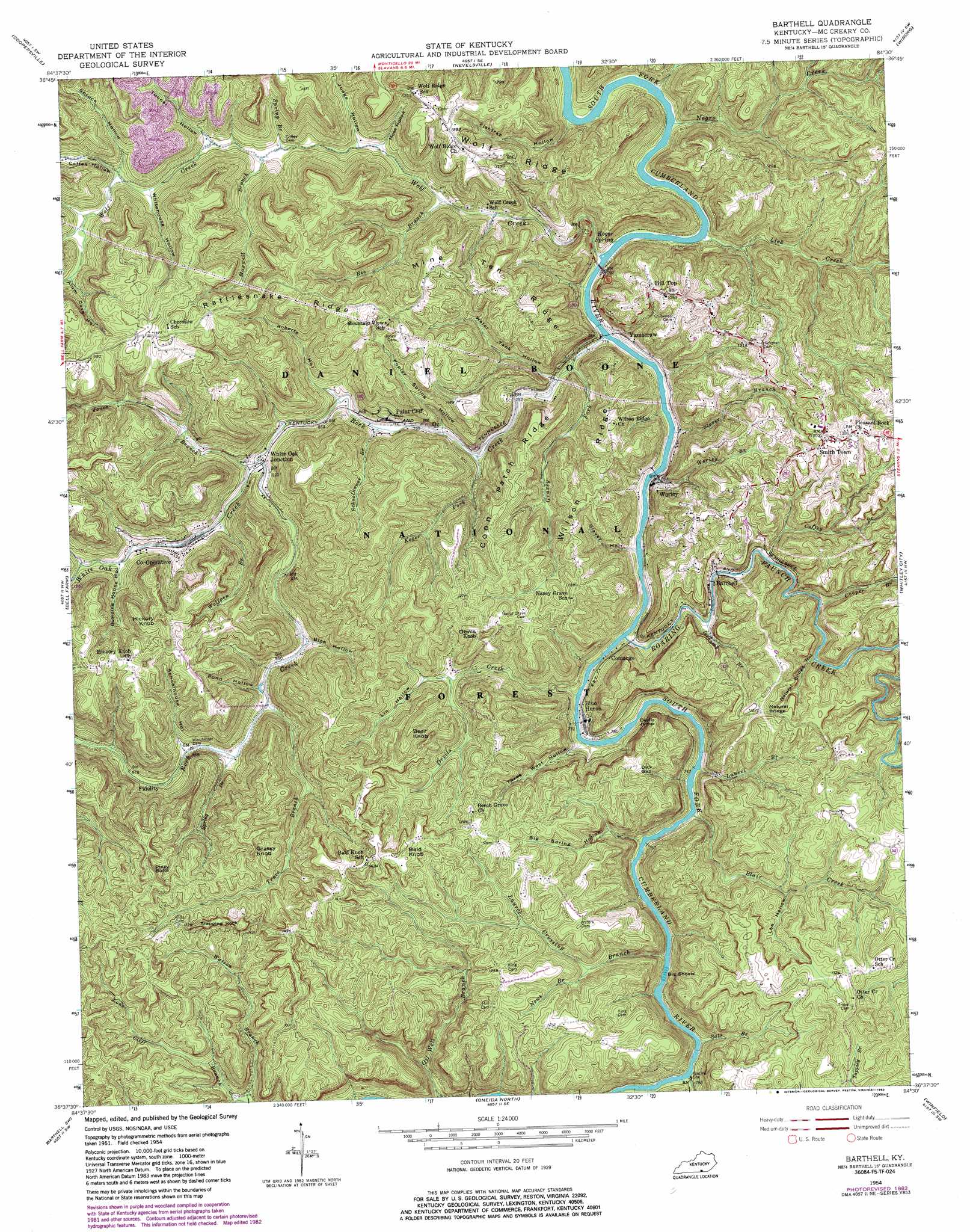
Barthell Topo Map Kentucky
To zoom in, hover over the map of Barthell
USGS Topo Quad 36084f5 - 1:24,000 scale
| Topo Map Name: | Barthell |
| USGS Topo Quad ID: | 36084f5 |
| Print Size: | ca. 21 1/4" wide x 27" high |
| Southeast Coordinates: | 36.625° N latitude / 84.5° W longitude |
| Map Center Coordinates: | 36.6875° N latitude / 84.5625° W longitude |
| U.S. State: | KY |
| Filename: | o36084f5.jpg |
| Download Map JPG Image: | Barthell topo map 1:24,000 scale |
| Map Type: | Topographic |
| Topo Series: | 7.5´ |
| Map Scale: | 1:24,000 |
| Source of Map Images: | United States Geological Survey (USGS) |
| Alternate Map Versions: |
Barthell KY 1954, updated 1955 Download PDF Buy paper map Barthell KY 1954, updated 1968 Download PDF Buy paper map Barthell KY 1954, updated 1983 Download PDF Buy paper map Barthell KY 2010 Download PDF Buy paper map Barthell KY 2013 Download PDF Buy paper map Barthell KY 2016 Download PDF Buy paper map |
| FStopo: | US Forest Service topo Barthell is available: Download FStopo PDF Download FStopo TIF |
1:24,000 Topo Quads surrounding Barthell
Mill Springs |
Frazer |
Burnside |
Hail |
Sawyer |
Monticello |
Coopersville |
Nevelsville |
Wiborg |
Cumberland Falls |
Parmleysville |
Bell Farm |
Barthell |
Whitley City |
Hollyhill |
Sharp Place |
Barthell Sw |
Oneida North |
Winfield |
Ketchen |
Stockton |
Honey Creek |
Oneida South |
Huntsville |
Pioneer |
> Back to 36084e1 at 1:100,000 scale
> Back to 36084a1 at 1:250,000 scale
> Back to U.S. Topo Maps home
Barthell topo map: Gazetteer
Barthell: Bars
Big Shoals elevation 332m 1089′Barthell: Bridges
Natural Bridge elevation 370m 1213′Barthell: Cliffs
Bear Creek Overlook elevation 241m 790′Devils Jump elevation 360m 1181′
Paint Cliff elevation 275m 902′
Barthell: Gaps
Dick Gap elevation 303m 994′Barthell: Pillars
Stepping Rock elevation 397m 1302′Barthell: Populated Places
Barthell elevation 337m 1105′Big South Fork (historical) elevation 242m 793′
Blue Heron elevation 314m 1030′
Comargo elevation 344m 1128′
Co-Operative elevation 266m 872′
Fidelity elevation 284m 931′
Hill Top elevation 373m 1223′
Oz elevation 242m 793′
Smith Town elevation 389m 1276′
White Oak Junction elevation 308m 1010′
Worley elevation 273m 895′
Yamacraw elevation 301m 987′
Barthell: Post Offices
Big South Fork Post Office (historical) elevation 228m 748′Comargo Post Office (historical) elevation 229m 751′
Hill Top Post Office (historical) elevation 372m 1220′
Yamacraw Post Office (historical) elevation 244m 800′
Barthell: Rapids
Devils Jump Rapids elevation 220m 721′Barthell: Ridges
Coon Patch Ridge elevation 306m 1003′Mine Ten Ridge elevation 392m 1286′
Rattlesnake Ridge elevation 399m 1309′
Wilson Ridge elevation 310m 1017′
Barthell: Springs
Koger Spring elevation 235m 770′Barthell: Streams
Bear Creek elevation 235m 770′Bee Branch elevation 268m 879′
Blair Creek elevation 237m 777′
Cabin Branch elevation 282m 925′
Coffey Branch elevation 271m 889′
Cooper Branch elevation 351m 1151′
Devils Creek elevation 278m 912′
Grassy Fork elevation 290m 951′
Icecamp Branch elevation 252m 826′
Jones Branch elevation 245m 803′
Koger Fork elevation 300m 984′
Laurel Branch elevation 267m 875′
Laurel Crossing Branch elevation 306m 1003′
Lick Creek elevation 236m 774′
Maxwell Branch elevation 273m 895′
Negro Creek elevation 242m 793′
Newt Branch elevation 336m 1102′
Roaring Paunch Creek elevation 240m 787′
Rock Creek elevation 222m 728′
Salt Branch elevation 260m 853′
Schoolhouse Branch elevation 234m 767′
Spring Branch elevation 330m 1082′
Spring Branch elevation 273m 895′
Stover Branch elevation 278m 912′
Trace Branch elevation 283m 928′
White Oak Creek elevation 270m 885′
Wolf Creek elevation 250m 820′
Wolfpen Branch elevation 300m 984′
Worley Branch elevation 273m 895′
Barthell: Summits
Bald Knob elevation 371m 1217′Bear Knob elevation 373m 1223′
Devils Knob elevation 347m 1138′
Grassy Knob elevation 404m 1325′
Hickory Knob elevation 401m 1315′
Piney Butte elevation 411m 1348′
Barthell: Valleys
Alum Cave Hollow elevation 342m 1122′Bice Hollow elevation 263m 862′
Big Spring Hollow elevation 263m 862′
Boarding House Hollow elevation 275m 902′
Coffey Hollow elevation 283m 928′
Cotton Patch Hollow elevation 226m 741′
Fishtrap Hollow elevation 225m 738′
Judge Hollow elevation 254m 833′
Lee Hollow elevation 349m 1145′
Lin Hollow elevation 306m 1003′
Moss Hollow elevation 290m 951′
Natural Bridge Hollow elevation 302m 990′
Pond Hollow elevation 289m 948′
Poplar Spring Hollow elevation 251m 823′
Roberts Hollow elevation 244m 800′
Roberts Hollow elevation 286m 938′
Schoolhouse Hollow elevation 309m 1013′
Slavey Hollow elevation 252m 826′
Spruce Hollow elevation 282m 925′
Three West Hollow elevation 231m 757′
Tunnel Hollow elevation 267m 875′
Water Tank Hollow elevation 248m 813′
Whitehouse Hollow elevation 301m 987′
Barthell digital topo map on disk
Buy this Barthell topo map showing relief, roads, GPS coordinates and other geographical features, as a high-resolution digital map file on DVD: