Bell Farm Topo Map Kentucky
To zoom in, hover over the map of Bell Farm
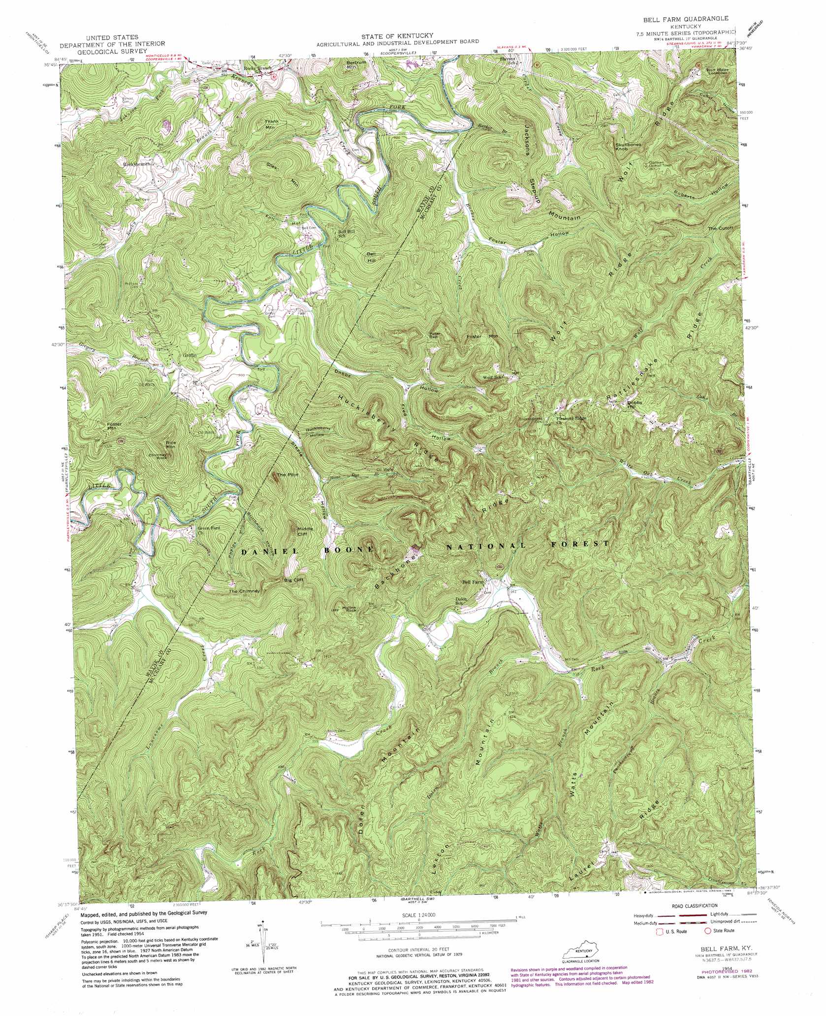
USGS Topo Quad 36084f6 - 1:24,000 scale
| Topo Map Name: | Bell Farm |
| USGS Topo Quad ID: | 36084f6 |
| Print Size: | ca. 21 1/4" wide x 27" high |
| Southeast Coordinates: | 36.625° N latitude / 84.625° W longitude |
| Map Center Coordinates: | 36.6875° N latitude / 84.6875° W longitude |
| U.S. State: | KY |
| Filename: | o36084f6.jpg |
| Download Map JPG Image: | Bell Farm topo map 1:24,000 scale |
| Map Type: | Topographic |
| Topo Series: | 7.5´ |
| Map Scale: | 1:24,000 |
| Source of Map Images: | United States Geological Survey (USGS) |
| Alternate Map Versions: |
Bell Farm KY 1954, updated 1955 Download PDF Buy paper map Bell Farm KY 1954, updated 1967 Download PDF Buy paper map Bell Farm KY 1954, updated 1983 Download PDF Buy paper map Bell Farm KY 2010 Download PDF Buy paper map Bell Farm KY 2013 Download PDF Buy paper map Bell Farm KY 2016 Download PDF Buy paper map |
| FStopo: | US Forest Service topo Bell Farm is available: Download FStopo PDF Download FStopo TIF |
1:24,000 Topo Quads surrounding Bell Farm
Jabez |
Mill Springs |
Frazer |
Burnside |
Hail |
Parnell |
Monticello |
Coopersville |
Nevelsville |
Wiborg |
Powersburg |
Parmleysville |
Bell Farm |
Barthell |
Whitley City |
Pall Mall |
Sharp Place |
Barthell Sw |
Oneida North |
Winfield |
Jamestown |
Stockton |
Honey Creek |
Oneida South |
Huntsville |
> Back to 36084e1 at 1:100,000 scale
> Back to 36084a1 at 1:250,000 scale
> Back to U.S. Topo Maps home
Bell Farm topo map: Gazetteer
Bell Farm: Cliffs
Big Cliff elevation 413m 1354′Middle Cliff elevation 423m 1387′
The Mill Cliff elevation 249m 816′
Bell Farm: Crossings
Bawley Ford elevation 242m 793′Denney Ford elevation 247m 810′
Green Ford elevation 254m 833′
Lonesome Ford elevation 256m 839′
Steele Ford elevation 252m 826′
Bell Farm: Gaps
Peter Gap elevation 406m 1332′The Cutoff elevation 364m 1194′
Bell Farm: Pillars
Chimney Rock elevation 437m 1433′Hollow Rock elevation 412m 1351′
Bell Farm: Populated Places
Griffin elevation 285m 935′Rockybranch elevation 291m 954′
Bell Farm: Post Offices
Bell Farm Post Office (historical) elevation 295m 967′Co-operative Post Office (historical) elevation 287m 941′
Gregory Post Office (historical) elevation 282m 925′
Griffin Post Office (historical) elevation 295m 967′
Rockybranch Post Office (historical) elevation 283m 928′
Bell Farm: Ridges
Backbone Ridge elevation 419m 1374′Huckleberry Ridge elevation 345m 1131′
Laurel Ridge elevation 439m 1440′
Bell Farm: Springs
The Frank Spring elevation 251m 823′Bell Farm: Streams
Burkes Branch elevation 279m 915′Burkes Creek elevation 243m 797′
Dolen Branch elevation 279m 915′
Gregory Branch elevation 272m 892′
Johnson Fork elevation 253m 830′
Kennedy Creek elevation 246m 807′
Lonesome Creek elevation 256m 839′
Puncheoncamp Branch elevation 273m 895′
Rocky Branch elevation 249m 816′
Stone Dye Branch elevation 269m 882′
Turkey Branch elevation 304m 997′
Watts Branch elevation 279m 915′
Bell Farm: Summits
Bell Hill elevation 380m 1246′Bertram Mountain elevation 388m 1272′
Dobbs Hill elevation 433m 1420′
Dolen Mountain elevation 453m 1486′
Foster Mountain elevation 398m 1305′
Frank Mountain elevation 379m 1243′
Jacksons Step-up Mountain elevation 369m 1210′
Lexton Mountain elevation 468m 1535′
Rice Mountain elevation 438m 1437′
Siles Mountain elevation 361m 1184′
Skullbones Knob elevation 380m 1246′
The Chimney elevation 423m 1387′
The Pilot elevation 411m 1348′
Watts Mountain elevation 443m 1453′
Bell Farm: Trails
Deer Loop elevation 366m 1200′Racoon Loop elevation 312m 1023′
Bell Farm: Valleys
Dobbs Hollow elevation 255m 836′Foster Hollow elevation 260m 853′
Fred Hollow elevation 286m 938′
Full Hollow elevation 246m 807′
Huckleberry Hollow elevation 263m 862′
Lonesome Valley elevation 261m 856′
Phelps Hollow elevation 261m 856′
Steele Hollow elevation 257m 843′
Stillhouse Hollow elevation 270m 885′
The Denny Hollow elevation 263m 862′
Bell Farm digital topo map on disk
Buy this Bell Farm topo map showing relief, roads, GPS coordinates and other geographical features, as a high-resolution digital map file on DVD: