Monticello Topo Map Kentucky
To zoom in, hover over the map of Monticello
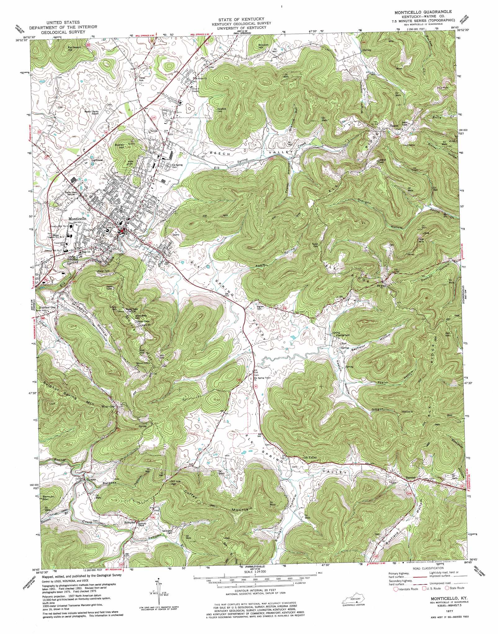
USGS Topo Quad 36084g7 - 1:24,000 scale
| Topo Map Name: | Monticello |
| USGS Topo Quad ID: | 36084g7 |
| Print Size: | ca. 21 1/4" wide x 27" high |
| Southeast Coordinates: | 36.75° N latitude / 84.75° W longitude |
| Map Center Coordinates: | 36.8125° N latitude / 84.8125° W longitude |
| U.S. State: | KY |
| Filename: | o36084g7.jpg |
| Download Map JPG Image: | Monticello topo map 1:24,000 scale |
| Map Type: | Topographic |
| Topo Series: | 7.5´ |
| Map Scale: | 1:24,000 |
| Source of Map Images: | United States Geological Survey (USGS) |
| Alternate Map Versions: |
Monticello KY 1953, updated 1955 Download PDF Buy paper map Monticello KY 1953, updated 1965 Download PDF Buy paper map Monticello KY 1977, updated 1977 Download PDF Buy paper map Monticello KY 2010 Download PDF Buy paper map Monticello KY 2013 Download PDF Buy paper map Monticello KY 2016 Download PDF Buy paper map |
1:24,000 Topo Quads surrounding Monticello
Russell Springs |
Eli |
Faubush |
Delmer |
Somerset |
Jamestown |
Jabez |
Mill Springs |
Frazer |
Burnside |
Cumberland City |
Parnell |
Monticello |
Coopersville |
Nevelsville |
Savage |
Powersburg |
Parmleysville |
Bell Farm |
Barthell |
Moodyville |
Pall Mall |
Sharp Place |
Barthell Sw |
Oneida North |
> Back to 36084e1 at 1:100,000 scale
> Back to 36084a1 at 1:250,000 scale
> Back to U.S. Topo Maps home
Monticello topo map: Gazetteer
Monticello: Airports
Wayne County Airport elevation 290m 951′Wayne County Hospital Heliport elevation 279m 915′
Monticello: Cliffs
The Sand Cliff elevation 398m 1305′Monticello: Pillars
The Round Rock elevation 434m 1423′Monticello: Populated Places
Barrier elevation 292m 958′Cooper elevation 265m 869′
Monticello elevation 281m 921′
Number One elevation 286m 938′
Oil Valley elevation 301m 987′
Spann elevation 427m 1400′
Sumpter elevation 289m 948′
Wray Gap elevation 353m 1158′
Monticello: Post Offices
Barrier Post Office (historical) elevation 294m 964′Oil Valley Post Office (historical) elevation 296m 971′
Shoemaker Post Office (historical) elevation 292m 958′
Spann Post Office (historical) elevation 433m 1420′
Sumpter Post Office (historical) elevation 289m 948′
Monticello: Reservoirs
Cross Pond elevation 293m 961′Four Neck Pond elevation 287m 941′
Monticello: Ridges
Elk Ridge elevation 450m 1476′Elk Ridge elevation 447m 1466′
Monticello: Springs
Doublehead Spring elevation 364m 1194′Elk Spring elevation 285m 935′
Elk Spring elevation 286m 938′
Ike Burke Spring elevation 302m 990′
Kendrick Spring elevation 293m 961′
Kendrick Spring elevation 304m 997′
Monnie Flynn Spring elevation 304m 997′
Monticello: Streams
Duncan Branch elevation 265m 869′Sumpter Branch elevation 273m 895′
Monticello: Summits
Bartleson Hill elevation 415m 1361′Buster Hill elevation 360m 1181′
Coffey Mountain elevation 412m 1351′
Dobbs Mountain elevation 450m 1476′
Hickory Nut Hill elevation 324m 1062′
Kendrick Mountain elevation 430m 1410′
Morris Hill elevation 470m 1541′
Sulphur Spring Mountain elevation 448m 1469′
Tank Knob elevation 465m 1525′
The Pinnacle elevation 453m 1486′
Wilhite Mountain elevation 431m 1414′
Monticello: Valleys
Aggie Hollow elevation 293m 961′Bachelor Hollow elevation 289m 948′
Beech Valley elevation 294m 964′
Burfield Hollow elevation 291m 954′
Burgess Hollow elevation 269m 882′
Burnett Hollow elevation 284m 931′
Draughn Hollow elevation 275m 902′
Duncan Valley elevation 281m 921′
Elk Spring Valley elevation 282m 925′
Foster Hollow elevation 292m 958′
Foster Hollow elevation 303m 994′
Gibson Hollow elevation 304m 997′
Grannie Hollow elevation 322m 1056′
Keeton Hollow elevation 282m 925′
Missouri Hollow elevation 288m 944′
Sloan Hollow elevation 304m 997′
Sumpter Hollow elevation 273m 895′
The One-Eye Hollow elevation 298m 977′
Wright Hollow elevation 301m 987′
Monticello digital topo map on disk
Buy this Monticello topo map showing relief, roads, GPS coordinates and other geographical features, as a high-resolution digital map file on DVD: