Parnell Topo Map Kentucky
To zoom in, hover over the map of Parnell
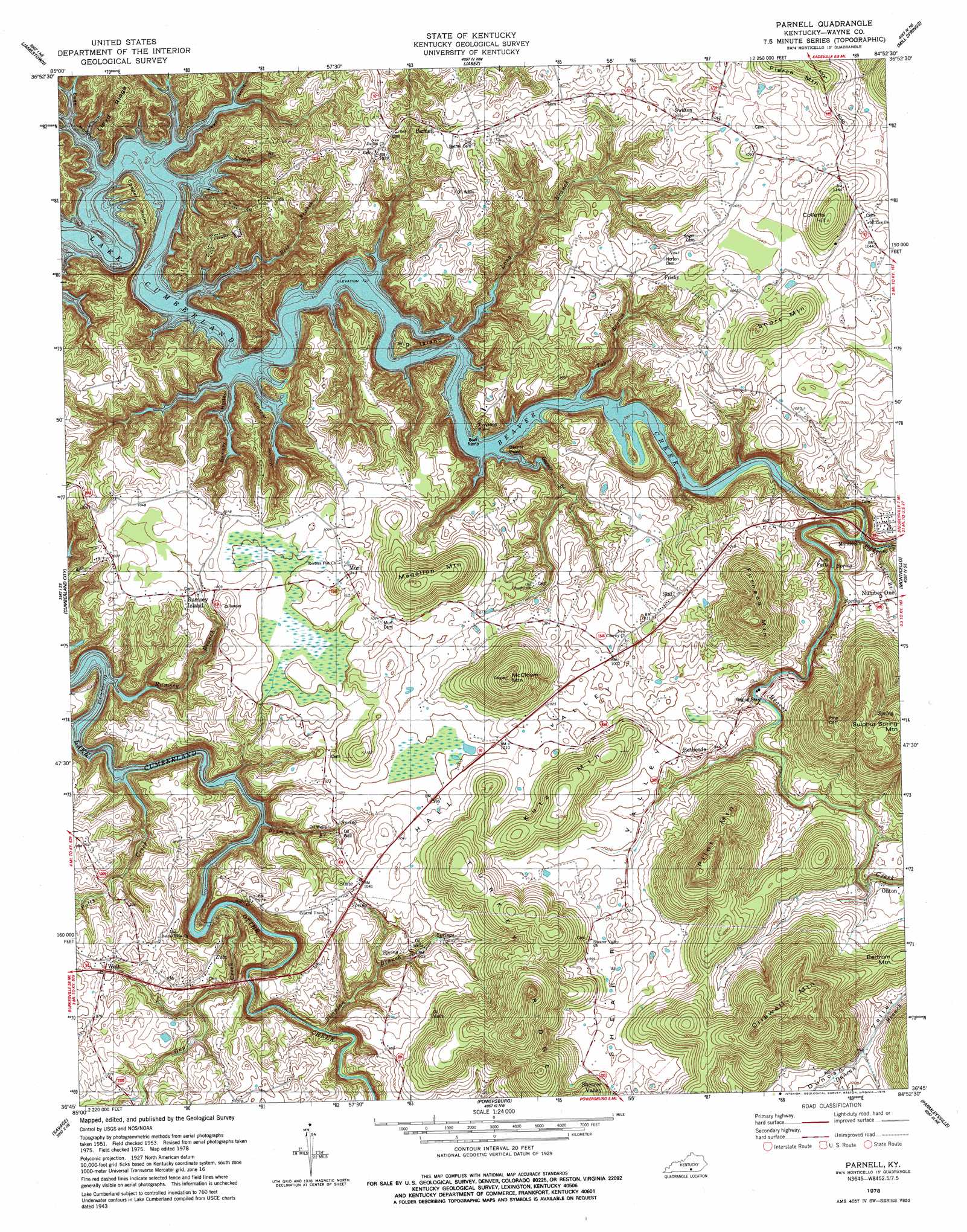
USGS Topo Quad 36084g8 - 1:24,000 scale
| Topo Map Name: | Parnell |
| USGS Topo Quad ID: | 36084g8 |
| Print Size: | ca. 21 1/4" wide x 27" high |
| Southeast Coordinates: | 36.75° N latitude / 84.875° W longitude |
| Map Center Coordinates: | 36.8125° N latitude / 84.9375° W longitude |
| U.S. State: | KY |
| Filename: | o36084g8.jpg |
| Download Map JPG Image: | Parnell topo map 1:24,000 scale |
| Map Type: | Topographic |
| Topo Series: | 7.5´ |
| Map Scale: | 1:24,000 |
| Source of Map Images: | United States Geological Survey (USGS) |
| Alternate Map Versions: |
Parnell KY 1953, updated 1955 Download PDF Buy paper map Parnell KY 1953, updated 1967 Download PDF Buy paper map Parnell KY 1978, updated 1979 Download PDF Buy paper map Parnell KY 2010 Download PDF Buy paper map Parnell KY 2013 Download PDF Buy paper map Parnell KY 2016 Download PDF Buy paper map |
1:24,000 Topo Quads surrounding Parnell
Montpelier |
Russell Springs |
Eli |
Faubush |
Delmer |
Creelsboro |
Jamestown |
Jabez |
Mill Springs |
Frazer |
Wolf Creek Dam |
Cumberland City |
Parnell |
Monticello |
Coopersville |
Albany |
Savage |
Powersburg |
Parmleysville |
Bell Farm |
Byrdstown |
Moodyville |
Pall Mall |
Sharp Place |
Barthell Sw |
> Back to 36084e1 at 1:100,000 scale
> Back to 36084a1 at 1:250,000 scale
> Back to U.S. Topo Maps home
Parnell topo map: Gazetteer
Parnell: Basins
Hall Valley elevation 309m 1013′Parnell: Bridges
Beaver Creek Bridge elevation 233m 764′Zula Bridge elevation 220m 721′
Parnell: Capes
Cooper Point elevation 250m 820′Garner Point elevation 230m 754′
Twyford Point elevation 222m 728′
Parnell: Cliffs
Blue Hole Cliff elevation 235m 770′Pine Cliff elevation 394m 1292′
Winding Stairs elevation 269m 882′
Parnell: Crossings
Ards Ford elevation 248m 813′Dug Ford (historical) elevation 274m 898′
Lynch Ford elevation 220m 721′
Parnell: Falls
Jock Falls elevation 259m 849′Parnell: Flats
Owens Bottom elevation 233m 764′Parnell: Islands
Big Island elevation 256m 839′Parnell: Populated Places
Bethesda elevation 296m 971′Frisby elevation 313m 1026′
Murl elevation 316m 1036′
Oilton elevation 280m 918′
Parnell elevation 312m 1023′
Ramsey Island elevation 313m 1026′
Shearer Valley elevation 338m 1108′
Short Mountain elevation 372m 1220′
Slat elevation 317m 1040′
Stop (historical) elevation 310m 1017′
Susie elevation 317m 1040′
Swifton elevation 324m 1062′
Wait elevation 308m 1010′
Zula elevation 286m 938′
Parnell: Post Offices
Alex Post Office (historical) elevation 308m 1010′Bethesda Post Office (historical) elevation 299m 980′
Flat Springs Post Office (historical) elevation 271m 889′
Frisby Post Office (historical) elevation 312m 1023′
Murl Post Office (historical) elevation 312m 1023′
Oilton Post Office (historical) elevation 270m 885′
Paisley Post Office (historical) elevation 265m 869′
Parnell Post Office (historical) elevation 318m 1043′
Shearer Valley Post Office (historical) elevation 336m 1102′
Slat Post Office (historical) elevation 306m 1003′
Stop Post Office (historical) elevation 303m 994′
Susie Post Office (historical) elevation 318m 1043′
Swifton Post Office (historical) elevation 319m 1046′
Turkey Ridge Post Office (historical) elevation 378m 1240′
Wait Post Office (historical) elevation 305m 1000′
Zula Mill (historical) elevation 223m 731′
Zula Post Office (historical) elevation 287m 941′
Parnell: Ridges
Beaver Creek Narrows elevation 248m 813′Buffalo Ridge elevation 280m 918′
Lloyd Ridge elevation 308m 1010′
Turkey Ridge elevation 472m 1548′
Parnell: Springs
Flat Springs elevation 266m 872′Spring Oil Hole elevation 238m 780′
Parnell: Streams
Barnes Branch elevation 220m 721′Bell Branch elevation 220m 721′
Brammer Branch elevation 220m 721′
Cooper Branch elevation 241m 790′
Elk Spring Creek elevation 220m 721′
Gap Creek elevation 224m 734′
Garner Branch elevation 220m 721′
Isbell Branch elevation 240m 787′
Long Branch elevation 220m 721′
Ollie Branch elevation 224m 734′
Potts Creek elevation 220m 721′
Ramsey Branch elevation 220m 721′
Simpson Branch elevation 228m 748′
Tabor Branch elevation 220m 721′
Parnell: Summits
Bertrum Mountain elevation 369m 1210′Colletts Hill elevation 384m 1259′
Criswell Mountain elevation 472m 1548′
Furnace Mountain elevation 452m 1482′
Kutz Mountain elevation 382m 1253′
Magallon Mountain elevation 398m 1305′
McClown Mountain elevation 451m 1479′
Pierce Mountain elevation 368m 1207′
Pilot Mountain elevation 433m 1420′
Pump Station Hill elevation 258m 846′
Parnell: Valleys
Claude Phipps Hollow elevation 228m 748′Cooper Hollow elevation 220m 721′
Eads Hollow elevation 220m 721′
Lloyd Hollow elevation 220m 721′
Ramsey Hollow elevation 220m 721′
Shearer Valley elevation 255m 836′
Simpson Hollow elevation 243m 797′
Parnell digital topo map on disk
Buy this Parnell topo map showing relief, roads, GPS coordinates and other geographical features, as a high-resolution digital map file on DVD: