Corbin Topo Map Kentucky
To zoom in, hover over the map of Corbin
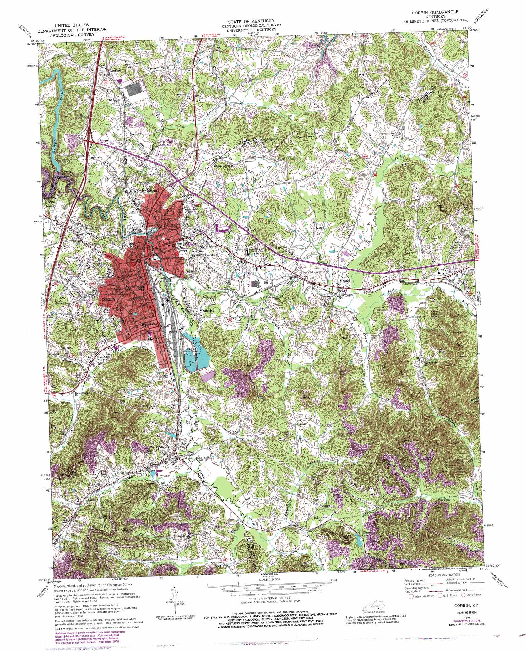
USGS Topo Quad 36084h1 - 1:24,000 scale
| Topo Map Name: | Corbin |
| USGS Topo Quad ID: | 36084h1 |
| Print Size: | ca. 21 1/4" wide x 27" high |
| Southeast Coordinates: | 36.875° N latitude / 84° W longitude |
| Map Center Coordinates: | 36.9375° N latitude / 84.0625° W longitude |
| U.S. State: | KY |
| Filename: | o36084h1.jpg |
| Download Map JPG Image: | Corbin topo map 1:24,000 scale |
| Map Type: | Topographic |
| Topo Series: | 7.5´ |
| Map Scale: | 1:24,000 |
| Source of Map Images: | United States Geological Survey (USGS) |
| Alternate Map Versions: |
Corbin KY 1952, updated 1953 Download PDF Buy paper map Corbin KY 1961, updated 1963 Download PDF Buy paper map Corbin KY 1970, updated 1972 Download PDF Buy paper map Corbin KY 1970, updated 1978 Download PDF Buy paper map Corbin KY 1970, updated 1989 Download PDF Buy paper map Corbin KY 2010 Download PDF Buy paper map Corbin KY 2013 Download PDF Buy paper map Corbin KY 2016 Download PDF Buy paper map |
| FStopo: | US Forest Service topo Corbin is available: Download FStopo PDF Download FStopo TIF |
1:24,000 Topo Quads surrounding Corbin
Billows |
Bernstadt |
London |
Portersburg |
Manchester |
Ano |
London Sw |
Lily |
Blackwater |
Hima |
Sawyer |
Vox |
Corbin |
Heidrick |
Fount |
Cumberland Falls |
Wofford |
Rockholds |
Barbourville |
Artemus |
Hollyhill |
Williamsburg |
Saxton |
Frakes |
Kayjay |
> Back to 36084e1 at 1:100,000 scale
> Back to 36084a1 at 1:250,000 scale
> Back to U.S. Topo Maps home
Corbin topo map: Gazetteer
Corbin: Airports
Henry Field elevation 366m 1200′Corbin: Populated Places
Camp Grounds elevation 366m 1200′Corbin elevation 329m 1079′
Dorthae elevation 363m 1190′
Gray elevation 338m 1108′
Hopewell elevation 384m 1259′
Moore Hill elevation 346m 1135′
North Corbin elevation 338m 1108′
Siler elevation 338m 1108′
Wilton elevation 357m 1171′
Woodbine elevation 340m 1115′
Corbin: Post Offices
Gray Post Office elevation 341m 1118′Place Post Office (historical) elevation 339m 1112′
Steel Post Office (historical) elevation 405m 1328′
Watch Post Office (historical) elevation 355m 1164′
Wilton Post Office (historical) elevation 356m 1167′
Corbin: Reservoirs
Wilton Lake elevation 347m 1138′Corbin: Ridges
Candle Ridge elevation 367m 1204′Corbin: Streams
Bacon Creek elevation 329m 1079′Bingham Branch elevation 337m 1105′
Corn Creek elevation 334m 1095′
East Fork Lynn Camp Creek elevation 323m 1059′
Eaton Branch elevation 330m 1082′
Hazel Fork elevation 333m 1092′
Horse Creek elevation 322m 1056′
Lynn Camp Creek elevation 323m 1059′
Mills Fork elevation 302m 990′
Negro Creek elevation 331m 1085′
Spider Creek elevation 328m 1076′
Stewarts Creek elevation 334m 1095′
Stony Fork elevation 331m 1085′
Youngs Creek elevation 327m 1072′
Corbin: Valleys
Steel Hollow elevation 339m 1112′Corbin digital topo map on disk
Buy this Corbin topo map showing relief, roads, GPS coordinates and other geographical features, as a high-resolution digital map file on DVD: