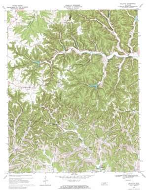
Willette Topo Map Tennessee
To zoom in, hover over the map of Willette
USGS Topo Quad 36085d7 - 1:24,000 scale
| Topo Map Name: | Willette |
| USGS Topo Quad ID: | 36085d7 |
| Print Size: | ca. 21 1/4" wide x 27" high |
| Southeast Coordinates: | 36.375° N latitude / 85.75° W longitude |
| Map Center Coordinates: | 36.4375° N latitude / 85.8125° W longitude |
| U.S. State: | TN |
| Filename: | o36085d7.jpg |
| Download Map JPG Image: | Willette topo map 1:24,000 scale |
| Map Type: | Topographic |
| Topo Series: | 7.5´ |
| Map Scale: | 1:24,000 |
| Source of Map Images: | United States Geological Survey (USGS) |
| Alternate Map Versions: |
Willette TN 1968, updated 1970 Download PDF Buy paper map Willette TN 2010 Download PDF Buy paper map Willette TN 2013 Download PDF Buy paper map Willette TN 2016 Download PDF Buy paper map |
1:24,000 Topo Quads surrounding Willette
> Back to 36085a1 at 1:100,000 scale
> Back to 36084a1 at 1:250,000 scale
> Back to U.S. Topo Maps home
Willette topo map: Gazetteer
Willette: Dams
Jennings Creek Number Eighteen Dam elevation 238m 780′Jennings Creek Watershed Dam Number Fifteen elevation 230m 754′
Jennings Creek Watershed Dam Number Seventeen elevation 231m 757′
Jennings Creek Watershed Dam Number Sixteen elevation 231m 757′
Jennings Creek Watershed Dam Number Thirteen elevation 212m 695′
Jennings Creek Watershed Number Ten Dam elevation 203m 666′
Willette: Populated Places
Cartwright elevation 180m 590′Goose Horn elevation 313m 1026′
Milltown elevation 161m 528′
North Springs elevation 184m 603′
Prosperity elevation 311m 1020′
Willette elevation 305m 1000′
Willette: Reservoirs
Jennings Creek Lake Number Eighteen elevation 238m 780′Jennings Creek Watershed Number Ten Lake elevation 203m 666′
Lake Number Fifteen elevation 230m 754′
Lake Number Seventeen elevation 231m 757′
Lake Number Sixteen elevation 231m 757′
Lake Number Thirteen elevation 212m 695′
Willette: Ridges
Goose Horn Ridge elevation 306m 1003′Willette: Streams
Bee Branch elevation 188m 616′Carver Branch elevation 181m 593′
Clark Branch elevation 192m 629′
Crabtree Creek elevation 181m 593′
Dry Branch elevation 157m 515′
East Fork Wartrace Creek elevation 154m 505′
Halls Branch elevation 162m 531′
Hudson Creek elevation 180m 590′
Pigeon Branch elevation 165m 541′
Skaggs Branch elevation 182m 597′
Ward Fork elevation 192m 629′
Willette: Valleys
Agee Hollow elevation 188m 616′Bold Spring Hollow elevation 220m 721′
Buchanan Hollow elevation 204m 669′
Carver Hollow elevation 183m 600′
Clark Hollow elevation 193m 633′
Cook Hollow elevation 158m 518′
Cox Hollow elevation 184m 603′
Donoho Hollow elevation 206m 675′
Green Hollow elevation 188m 616′
Hall Hollow elevation 162m 531′
Hance Hollow elevation 189m 620′
Hudson Hollow elevation 197m 646′
Long Hollow elevation 193m 633′
Maynor Hollow elevation 198m 649′
McCormick Hollow elevation 202m 662′
Ray Hollow elevation 169m 554′
Rockhouse Hollow elevation 221m 725′
Sloan Hollow elevation 163m 534′
Snead Hollow elevation 165m 541′
Steam Mill Hollow elevation 231m 757′
Sycamore Bottom elevation 170m 557′
Wilson Hollow elevation 174m 570′
Wolf Hollow elevation 215m 705′
Willette digital topo map on disk
Buy this Willette topo map showing relief, roads, GPS coordinates and other geographical features, as a high-resolution digital map file on DVD:


