Pleasant Shade Topo Map Tennessee
To zoom in, hover over the map of Pleasant Shade
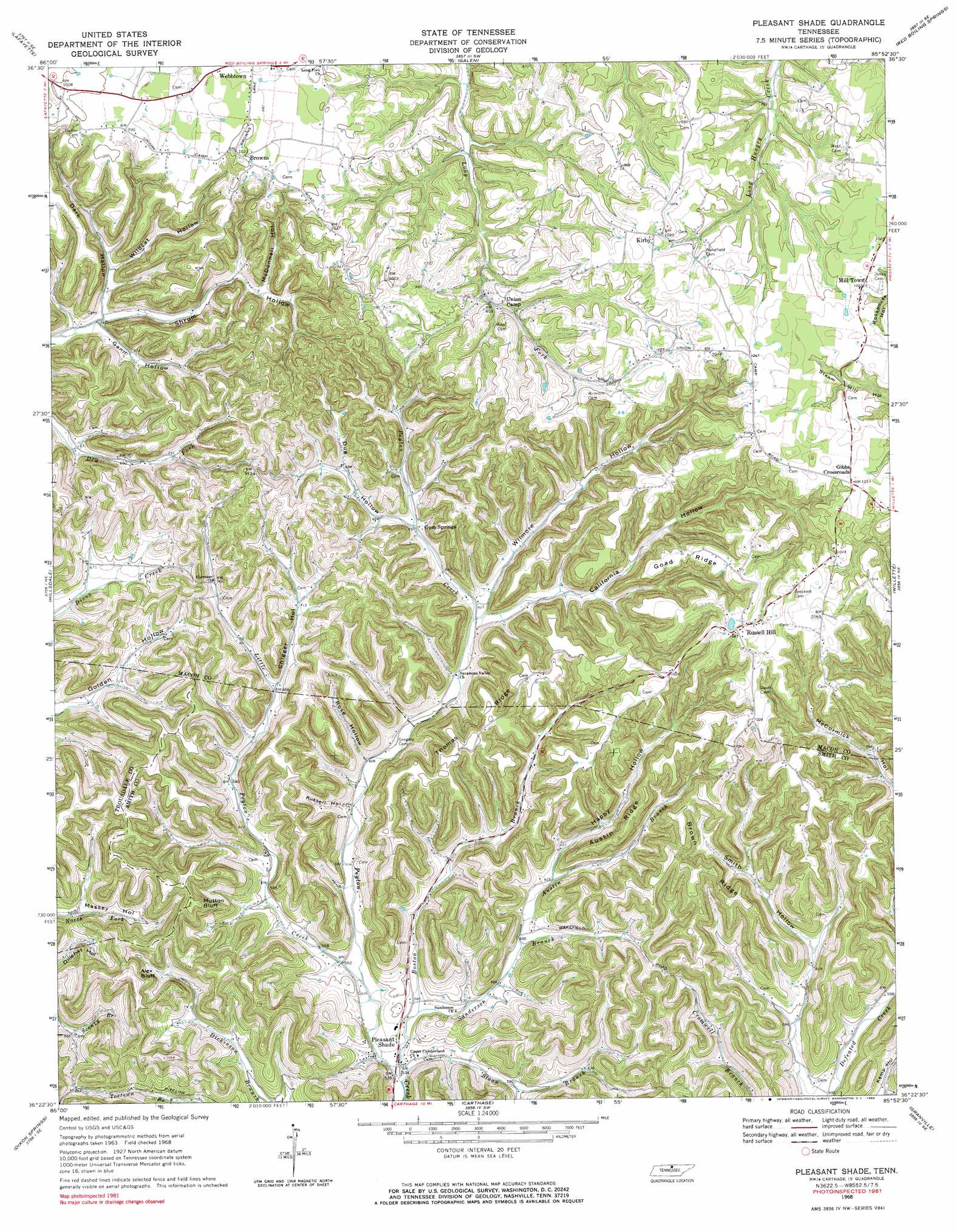
USGS Topo Quad 36085d8 - 1:24,000 scale
| Topo Map Name: | Pleasant Shade |
| USGS Topo Quad ID: | 36085d8 |
| Print Size: | ca. 21 1/4" wide x 27" high |
| Southeast Coordinates: | 36.375° N latitude / 85.875° W longitude |
| Map Center Coordinates: | 36.4375° N latitude / 85.9375° W longitude |
| U.S. State: | TN |
| Filename: | o36085d8.jpg |
| Download Map JPG Image: | Pleasant Shade topo map 1:24,000 scale |
| Map Type: | Topographic |
| Topo Series: | 7.5´ |
| Map Scale: | 1:24,000 |
| Source of Map Images: | United States Geological Survey (USGS) |
| Alternate Map Versions: |
Pleasant Shade TN 1968, updated 1970 Download PDF Buy paper map Pleasant Shade TN 1968, updated 1984 Download PDF Buy paper map Pleasant Shade TN 2010 Download PDF Buy paper map Pleasant Shade TN 2013 Download PDF Buy paper map Pleasant Shade TN 2016 Download PDF Buy paper map |
1:24,000 Topo Quads surrounding Pleasant Shade
Petroleum |
Holland |
Fountain Run |
Gamaliel |
Tompkinsville |
Westmoreland |
Lafayette |
Galen |
Red Boiling Springs |
Union Hill |
Hartsville |
Hillsdale |
Pleasant Shade |
Willette |
Whitleyville |
Bellwood |
Dixon Springs |
Carthage |
Granville |
Gainesboro |
Shop Springs |
New Middleton |
Gordonsville |
Buffalo Valley |
Baxter |
> Back to 36085a1 at 1:100,000 scale
> Back to 36084a1 at 1:250,000 scale
> Back to U.S. Topo Maps home
Pleasant Shade topo map: Gazetteer
Pleasant Shade: Cliffs
Alex Bluff elevation 286m 938′Mutton Bluff elevation 292m 958′
Pleasant Shade: Populated Places
Browns elevation 311m 1020′Gibbs Crossroads elevation 306m 1003′
Gum Springs elevation 201m 659′
Kirby elevation 308m 1010′
Macey elevation 244m 800′
Mill Town elevation 310m 1017′
Olio elevation 205m 672′
Pleasant Shade elevation 160m 524′
Russell Hill elevation 324m 1062′
Pleasant Shade: Post Offices
Pleasant Shade Post Office elevation 161m 528′Pleasant Shade: Ridges
Austin Ridge elevation 302m 990′Brown Ridge elevation 310m 1017′
Goad Ridge elevation 317m 1040′
Hesson Ridge elevation 316m 1036′
Sircy Ridge elevation 314m 1030′
Thomas Ridge elevation 300m 984′
Pleasant Shade: Streams
Austin Branch elevation 180m 590′Boston Branch elevation 160m 524′
Little Peyton Creek elevation 166m 544′
Sanderson Branch elevation 165m 541′
Sloan Branch elevation 162m 531′
Pleasant Shade: Valleys
Austin Hollow elevation 187m 613′California Hollow elevation 188m 616′
Chigger Hollow elevation 203m 666′
Dug Hollow elevation 196m 643′
Gann Hollow elevation 200m 656′
Happy Hollow elevation 194m 636′
McDonnell Hollow elevation 245m 803′
Rose Hollow elevation 178m 583′
Russell Hollow elevation 175m 574′
Shrum Hollow elevation 196m 643′
Wildcat Hollow elevation 215m 705′
Wilmore Hollow elevation 189m 620′
Pleasant Shade digital topo map on disk
Buy this Pleasant Shade topo map showing relief, roads, GPS coordinates and other geographical features, as a high-resolution digital map file on DVD: