Dale Hollow Reservoir Se Topo Map Tennessee
To zoom in, hover over the map of Dale Hollow Reservoir Se
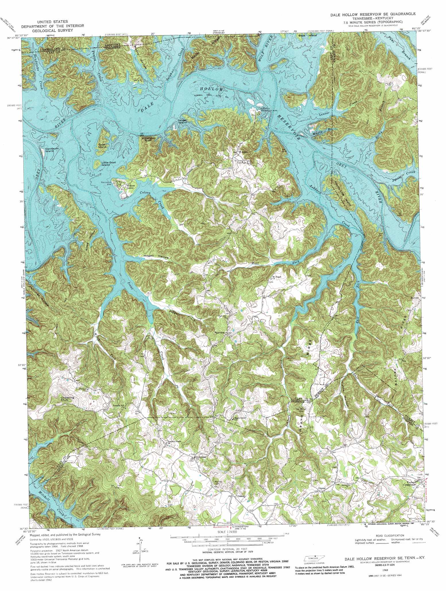
USGS Topo Quad 36085e3 - 1:24,000 scale
| Topo Map Name: | Dale Hollow Reservoir Se |
| USGS Topo Quad ID: | 36085e3 |
| Print Size: | ca. 21 1/4" wide x 27" high |
| Southeast Coordinates: | 36.5° N latitude / 85.25° W longitude |
| Map Center Coordinates: | 36.5625° N latitude / 85.3125° W longitude |
| U.S. States: | TN, KY |
| Filename: | o36085e3.jpg |
| Download Map JPG Image: | Dale Hollow Reservoir Se topo map 1:24,000 scale |
| Map Type: | Topographic |
| Topo Series: | 7.5´ |
| Map Scale: | 1:24,000 |
| Source of Map Images: | United States Geological Survey (USGS) |
| Alternate Map Versions: |
Dale Hollow Reservoir SE TN 1968, updated 1971 Download PDF Buy paper map Dale Hollow Reservoir SE TN 1968, updated 1987 Download PDF Buy paper map Dale Hollow Reservoir SE TN 2010 Download PDF Buy paper map Dale Hollow Reservoir SE TN 2013 Download PDF Buy paper map Dale Hollow Reservoir SE TN 2016 Download PDF Buy paper map |
1:24,000 Topo Quads surrounding Dale Hollow Reservoir Se
Dubre |
Waterview |
Burkesville |
Wolf Creek Dam |
Cumberland City |
Vernon |
Blacks Ferry |
Frogue |
Albany |
Savage |
Celina |
Dale Hollow Dam |
Dale Hollow Reservoir Se |
Byrdstown |
Moodyville |
Burristown |
Hilham |
Livingston |
Alpine |
Riverton |
Dodson Branch |
Windle |
Okalona |
Crawford |
Wilder |
> Back to 36085e1 at 1:100,000 scale
> Back to 36084a1 at 1:250,000 scale
> Back to U.S. Topo Maps home
Dale Hollow Reservoir Se topo map: Gazetteer
Dale Hollow Reservoir Se: Bends
Johnson Bend (historical) elevation 198m 649′Dale Hollow Reservoir Se: Cliffs
Accordion Bluff elevation 212m 695′Dale Hollow Reservoir Se: Dams
Akers Lake Dam elevation 273m 895′Dale Hollow Reservoir Se: Flats
Willis Bottom (historical) elevation 198m 649′Dale Hollow Reservoir Se: Islands
County Line Island elevation 260m 853′Geiger Island elevation 204m 669′
Goat Island elevation 225m 738′
Little Goat Island elevation 212m 695′
Opossum Island elevation 200m 656′
Dale Hollow Reservoir Se: Parks
Lillydale Recreation Area elevation 199m 652′Willow Grove Recreation Area elevation 214m 702′
Dale Hollow Reservoir Se: Populated Places
Fairview elevation 305m 1000′Lillydale (historical) elevation 198m 649′
Oakley elevation 319m 1046′
Ozone elevation 315m 1033′
Saint John elevation 276m 905′
Taylors Crossroads elevation 305m 1000′
Willow Grove elevation 209m 685′
Dale Hollow Reservoir Se: Reservoirs
Akers Lake elevation 273m 895′Dale Hollow Reservoir Se: Ridges
Barnes Ridge elevation 312m 1023′Boom Ridge elevation 251m 823′
Heard Ridge elevation 290m 951′
Mohawk Ridge elevation 321m 1053′
Dale Hollow Reservoir Se: Streams
Ashburn Creek elevation 198m 649′Colson Creek elevation 198m 649′
East Fork Ashburn Creek elevation 198m 649′
Hendricks Creek elevation 198m 649′
Hendricks Creek elevation 198m 649′
Irons Creek elevation 198m 649′
Jouett Creek elevation 198m 649′
Lanear Creek elevation 198m 649′
Muddy Branch elevation 198m 649′
Pusley Creek elevation 198m 649′
Pusley Creek elevation 198m 649′
Rocky Branch elevation 198m 649′
Sidwell Creek elevation 198m 649′
Stillhouse Creek (historical) elevation 198m 649′
Sulphur Creek elevation 198m 649′
Sulphur Creek elevation 198m 649′
West Fork Ashburn Creek elevation 198m 649′
Wiley Fork elevation 198m 649′
Wolf River elevation 198m 649′
Wolf River elevation 198m 649′
Wolf River elevation 198m 649′
Dale Hollow Reservoir Se: Summits
Chowning Knob elevation 392m 1286′Dale Hollow Reservoir Se: Valleys
Allred Hollow elevation 198m 649′Hogan Hollow elevation 198m 649′
Moore Hollow elevation 198m 649′
Moore Hollow elevation 198m 649′
Onvy Hollow elevation 221m 725′
Tipton Hollow elevation 204m 669′
Dale Hollow Reservoir Se digital topo map on disk
Buy this Dale Hollow Reservoir Se topo map showing relief, roads, GPS coordinates and other geographical features, as a high-resolution digital map file on DVD: