Dale Hollow Dam Topo Map Tennessee
To zoom in, hover over the map of Dale Hollow Dam
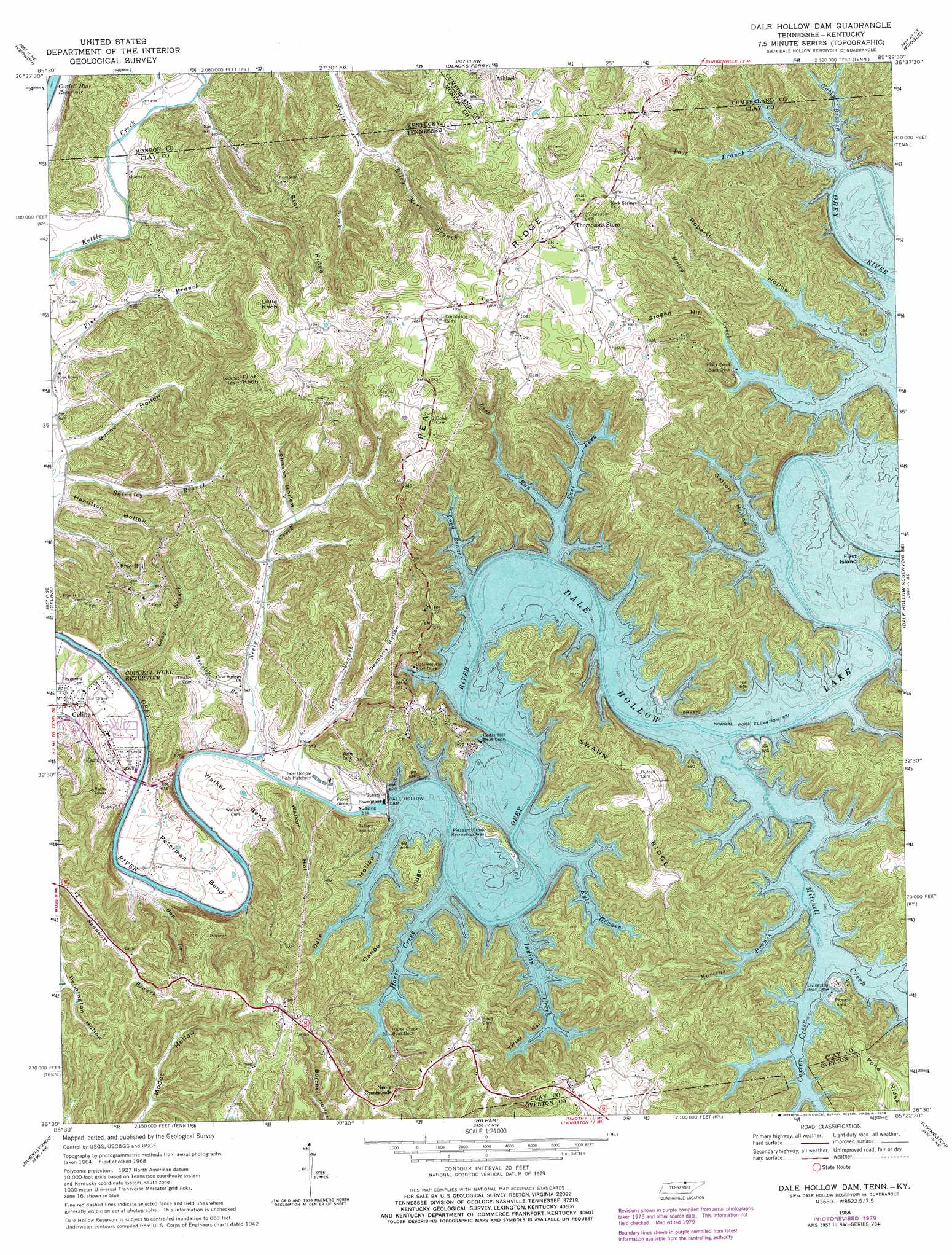
USGS Topo Quad 36085e4 - 1:24,000 scale
| Topo Map Name: | Dale Hollow Dam |
| USGS Topo Quad ID: | 36085e4 |
| Print Size: | ca. 21 1/4" wide x 27" high |
| Southeast Coordinates: | 36.5° N latitude / 85.375° W longitude |
| Map Center Coordinates: | 36.5625° N latitude / 85.4375° W longitude |
| U.S. States: | TN, KY |
| Filename: | o36085e4.jpg |
| Download Map JPG Image: | Dale Hollow Dam topo map 1:24,000 scale |
| Map Type: | Topographic |
| Topo Series: | 7.5´ |
| Map Scale: | 1:24,000 |
| Source of Map Images: | United States Geological Survey (USGS) |
| Alternate Map Versions: |
Dale Hollow Dam TN 1968, updated 1971 Download PDF Buy paper map Dale Hollow Dam TN 1968, updated 1979 Download PDF Buy paper map Dale Hollow Dam TN 1968, updated 1979 Download PDF Buy paper map Dale Hollow Dam TN 2010 Download PDF Buy paper map Dale Hollow Dam TN 2013 Download PDF Buy paper map Dale Hollow Dam TN 2016 Download PDF Buy paper map |
1:24,000 Topo Quads surrounding Dale Hollow Dam
Sulphur Lick |
Dubre |
Waterview |
Burkesville |
Wolf Creek Dam |
Tompkinsville |
Vernon |
Blacks Ferry |
Frogue |
Albany |
Union Hill |
Celina |
Dale Hollow Dam |
Dale Hollow Reservoir Se |
Byrdstown |
Whitleyville |
Burristown |
Hilham |
Livingston |
Alpine |
Gainesboro |
Dodson Branch |
Windle |
Okalona |
Crawford |
> Back to 36085e1 at 1:100,000 scale
> Back to 36084a1 at 1:250,000 scale
> Back to U.S. Topo Maps home
Dale Hollow Dam topo map: Gazetteer
Dale Hollow Dam: Bends
Barksdale Bend (historical) elevation 196m 643′Dale Bend (historical) elevation 196m 643′
Goodpasture Bend (historical) elevation 196m 643′
Keene Bend (historical) elevation 196m 643′
Peterman Bend elevation 166m 544′
Sewell Bend (historical) elevation 196m 643′
Walker Bend elevation 182m 597′
Dale Hollow Dam: Crossings
Barksdales Ferry (historical) elevation 196m 643′Dale Hollow Dam: Dams
Dale Hollow Dam elevation 193m 633′Standing Stone Dam elevation 294m 964′
Dale Hollow Dam: Flats
Modoc Bottom (historical) elevation 196m 643′Dale Hollow Dam: Islands
First Island elevation 202m 662′Dale Hollow Dam: Parks
Dale Hollow Dam Recreation Area elevation 163m 534′Pleasant Grove Recreation Area elevation 225m 738′
Dale Hollow Dam: Populated Places
Ashlock elevation 305m 1000′Cave Springs elevation 167m 547′
Fox Springs (historical) elevation 203m 666′
Free Hill elevation 188m 616′
Neely Crossroads elevation 276m 905′
Pea Ridge elevation 319m 1046′
Shanky Branch elevation 198m 649′
Thompsons Store elevation 315m 1033′
Dale Hollow Dam: Ranges
Free Hills elevation 274m 898′Dale Hollow Dam: Reservoirs
Cordell Hull Reservoir elevation 150m 492′Dale Hollow Lake elevation 193m 633′
Standing Stone Lake elevation 294m 964′
Dale Hollow Dam: Ridges
Canoe Ridge elevation 256m 839′Pea Ridge elevation 319m 1046′
Pond Ridge elevation 356m 1167′
Star Ridge elevation 255m 836′
Swann Ridge elevation 348m 1141′
Dale Hollow Dam: Streams
Carter Creek elevation 196m 643′Dry Branch elevation 165m 541′
East Fork Lick Run elevation 196m 643′
Gap Branch elevation 151m 495′
Holly Creek elevation 196m 643′
Horse Creek elevation 196m 643′
Indian Creek elevation 196m 643′
Kyle Branch elevation 196m 643′
Lick Run elevation 196m 643′
Long Branch elevation 196m 643′
Long Branch elevation 156m 511′
Martins Branch elevation 196m 643′
Mitchell Creek elevation 196m 643′
Natty Branch elevation 196m 643′
Natty Branch elevation 196m 643′
Neely Creek elevation 158m 518′
Poor Branch elevation 196m 643′
Riley Kerr Branch elevation 181m 593′
Smith Creek elevation 178m 583′
Tinsley Branch elevation 162m 531′
Dale Hollow Dam: Summits
Grogan Hill elevation 280m 918′Little Knob elevation 396m 1299′
Pilot Knob elevation 429m 1407′
Dale Hollow Dam: Valleys
Barksdale Hollow elevation 162m 531′Dale Hollow elevation 196m 643′
Dewberry Hollow elevation 169m 554′
Galton Hollow elevation 196m 643′
Jennings Hollow elevation 197m 646′
Johnson Hollow elevation 184m 603′
Roberts Hollow elevation 196m 643′
Talley Hollow elevation 196m 643′
Walker Hollow elevation 161m 528′
Dale Hollow Dam digital topo map on disk
Buy this Dale Hollow Dam topo map showing relief, roads, GPS coordinates and other geographical features, as a high-resolution digital map file on DVD: