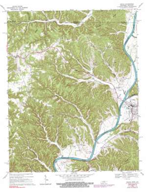
Celina Topo Map Tennessee
To zoom in, hover over the map of Celina
USGS Topo Quad 36085e5 - 1:24,000 scale
| Topo Map Name: | Celina |
| USGS Topo Quad ID: | 36085e5 |
| Print Size: | ca. 21 1/4" wide x 27" high |
| Southeast Coordinates: | 36.5° N latitude / 85.5° W longitude |
| Map Center Coordinates: | 36.5625° N latitude / 85.5625° W longitude |
| U.S. States: | TN, KY |
| Filename: | o36085e5.jpg |
| Download Map JPG Image: | Celina topo map 1:24,000 scale |
| Map Type: | Topographic |
| Topo Series: | 7.5´ |
| Map Scale: | 1:24,000 |
| Source of Map Images: | United States Geological Survey (USGS) |
| Alternate Map Versions: |
Celina TN 1968, updated 1971 Download PDF Buy paper map Celina TN 1968, updated 1979 Download PDF Buy paper map Celina TN 1968, updated 1984 Download PDF Buy paper map Celina TN 1968, updated 1990 Download PDF Buy paper map Celina TN 2010 Download PDF Buy paper map Celina TN 2013 Download PDF Buy paper map Celina TN 2016 Download PDF Buy paper map |
1:24,000 Topo Quads surrounding Celina
> Back to 36085e1 at 1:100,000 scale
> Back to 36084a1 at 1:250,000 scale
> Back to U.S. Topo Maps home
Celina topo map: Gazetteer
Celina: Bars
Celina Bar elevation 149m 488′Pine Branch Shoals elevation 149m 488′
Shut in Shoals elevation 151m 495′
Celina: Bends
Weaver Bottom elevation 160m 524′Celina: Bridges
Henry Horton Bridge elevation 149m 488′Celina: Cliffs
Knob Creek Bluff elevation 201m 659′Celina: Crossings
Bennett Ferry (historical) elevation 149m 488′Celina: Flats
Stones Bottom elevation 166m 544′Celina: Parks
Donaldson Park Recreation Area elevation 160m 524′Celina: Populated Places
Arcott elevation 175m 574′Celina elevation 169m 554′
Midway elevation 282m 925′
Moss elevation 336m 1102′
Richville elevation 300m 984′
Celina: Post Offices
Moss Post Office elevation 331m 1085′Celina: Ridges
Owl Ridge elevation 289m 948′Stephens Ridge elevation 257m 843′
Stephens Ridge elevation 270m 885′
Celina: Streams
Cooks Branch elevation 158m 518′Dry Branch elevation 155m 508′
Dry Creek elevation 152m 498′
Gnatty Branch elevation 152m 498′
Hunt Branch elevation 189m 620′
Kettle Creek elevation 151m 495′
Kettle Creek elevation 151m 495′
Knob Creek elevation 152m 498′
Little Proctor Creek elevation 155m 508′
Long Branch elevation 158m 518′
New Hope Branch elevation 165m 541′
Obey River elevation 151m 495′
Pine Branch elevation 153m 501′
Proctor Creek elevation 159m 521′
School Branch elevation 193m 633′
Shankey Branch elevation 151m 495′
Skinnicy Branch elevation 154m 505′
Spring Branch elevation 215m 705′
Celina: Valleys
Boone Hollow elevation 158m 518′Capshaw Hollow elevation 185m 606′
Hamilton Hollow elevation 154m 505′
Harp Hollow elevation 160m 524′
Pennington Hollow elevation 168m 551′
Celina digital topo map on disk
Buy this Celina topo map showing relief, roads, GPS coordinates and other geographical features, as a high-resolution digital map file on DVD:


