Vernon Topo Map Kentucky
To zoom in, hover over the map of Vernon
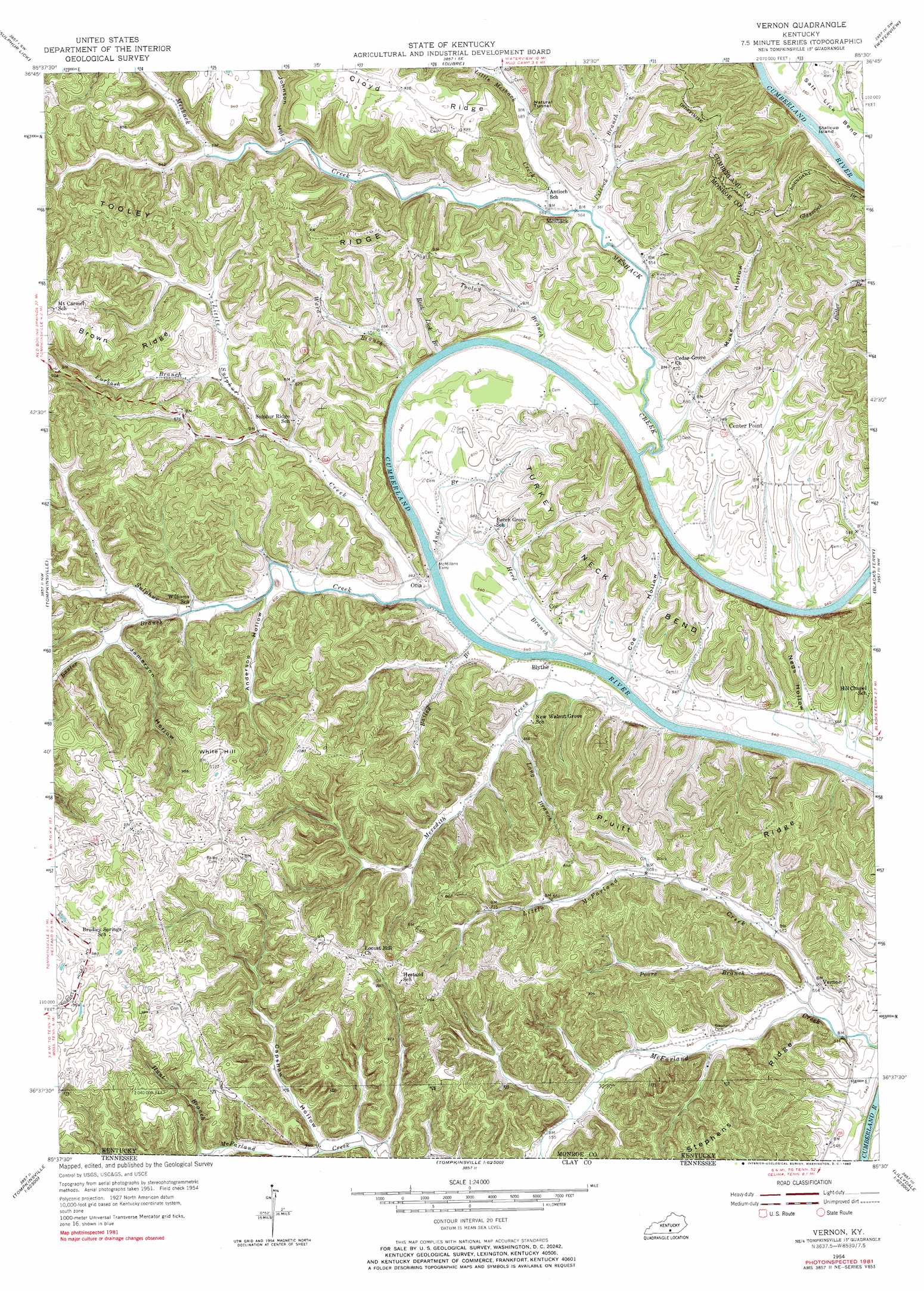
USGS Topo Quad 36085f5 - 1:24,000 scale
| Topo Map Name: | Vernon |
| USGS Topo Quad ID: | 36085f5 |
| Print Size: | ca. 21 1/4" wide x 27" high |
| Southeast Coordinates: | 36.625° N latitude / 85.5° W longitude |
| Map Center Coordinates: | 36.6875° N latitude / 85.5625° W longitude |
| U.S. State: | KY |
| Filename: | o36085f5.jpg |
| Download Map JPG Image: | Vernon topo map 1:24,000 scale |
| Map Type: | Topographic |
| Topo Series: | 7.5´ |
| Map Scale: | 1:24,000 |
| Source of Map Images: | United States Geological Survey (USGS) |
| Alternate Map Versions: |
Vernon KY 1954, updated 1955 Download PDF Buy paper map Vernon KY 1954, updated 1969 Download PDF Buy paper map Vernon KY 1981, updated 1983 Download PDF Buy paper map Vernon KY 2010 Download PDF Buy paper map Vernon KY 2013 Download PDF Buy paper map Vernon KY 2016 Download PDF Buy paper map |
1:24,000 Topo Quads surrounding Vernon
Temple Hill |
Summer Shade |
Edmonton |
Breeding |
Amandaville |
Freedom |
Sulphur Lick |
Dubre |
Waterview |
Burkesville |
Gamaliel |
Tompkinsville |
Vernon |
Blacks Ferry |
Frogue |
Red Boiling Springs |
Union Hill |
Celina |
Dale Hollow Dam |
Dale Hollow Reservoir Se |
Willette |
Whitleyville |
Burristown |
Hilham |
Livingston |
> Back to 36085e1 at 1:100,000 scale
> Back to 36084a1 at 1:250,000 scale
> Back to U.S. Topo Maps home
Vernon topo map: Gazetteer
Vernon: Bends
Salt Lick Bend elevation 171m 561′Turkey Neck Bend elevation 235m 770′
Vernon: Islands
Stallcup Island elevation 155m 508′Vernon: Populated Places
Blythe elevation 167m 547′Coe elevation 163m 534′
Meshack elevation 171m 561′
Otia elevation 173m 567′
Vernon elevation 169m 554′
Vernon: Ridges
Brown Ridge elevation 308m 1010′Cloyd Ridge elevation 283m 928′
Pruitt Ridge elevation 240m 787′
Tooley Ridge elevation 320m 1049′
Vernon: Streams
Andrews Branch elevation 156m 511′Bailey Branch elevation 159m 521′
Baxter Branch elevation 171m 561′
Furbush Branch elevation 181m 593′
Herd Branch elevation 163m 534′
Little McFarland Creek elevation 158m 518′
Little Meshack Creek elevation 169m 554′
Little Sulphur Creek elevation 159m 521′
Long Branch elevation 165m 541′
Meredith Creek elevation 158m 518′
Meshack Creek elevation 158m 518′
Pitcock Branch elevation 166m 544′
Poore Branch elevation 158m 518′
Rock Lick Branch elevation 170m 557′
Sulphur Creek elevation 157m 515′
Tooley Branch elevation 158m 518′
Ward Branch elevation 158m 518′
Vernon: Summits
White Hill elevation 342m 1122′Vernon: Tunnels
Natural Tunnel elevation 183m 600′Vernon: Valleys
Anderson Hollow elevation 169m 554′Coe Hollow elevation 158m 518′
Jamerson Hollow elevation 177m 580′
Johnson Hollow elevation 183m 600′
Muse Hollow elevation 172m 564′
Neds Hollow elevation 163m 534′
Vernon digital topo map on disk
Buy this Vernon topo map showing relief, roads, GPS coordinates and other geographical features, as a high-resolution digital map file on DVD: