New Middleton Topo Map Tennessee
To zoom in, hover over the map of New Middleton
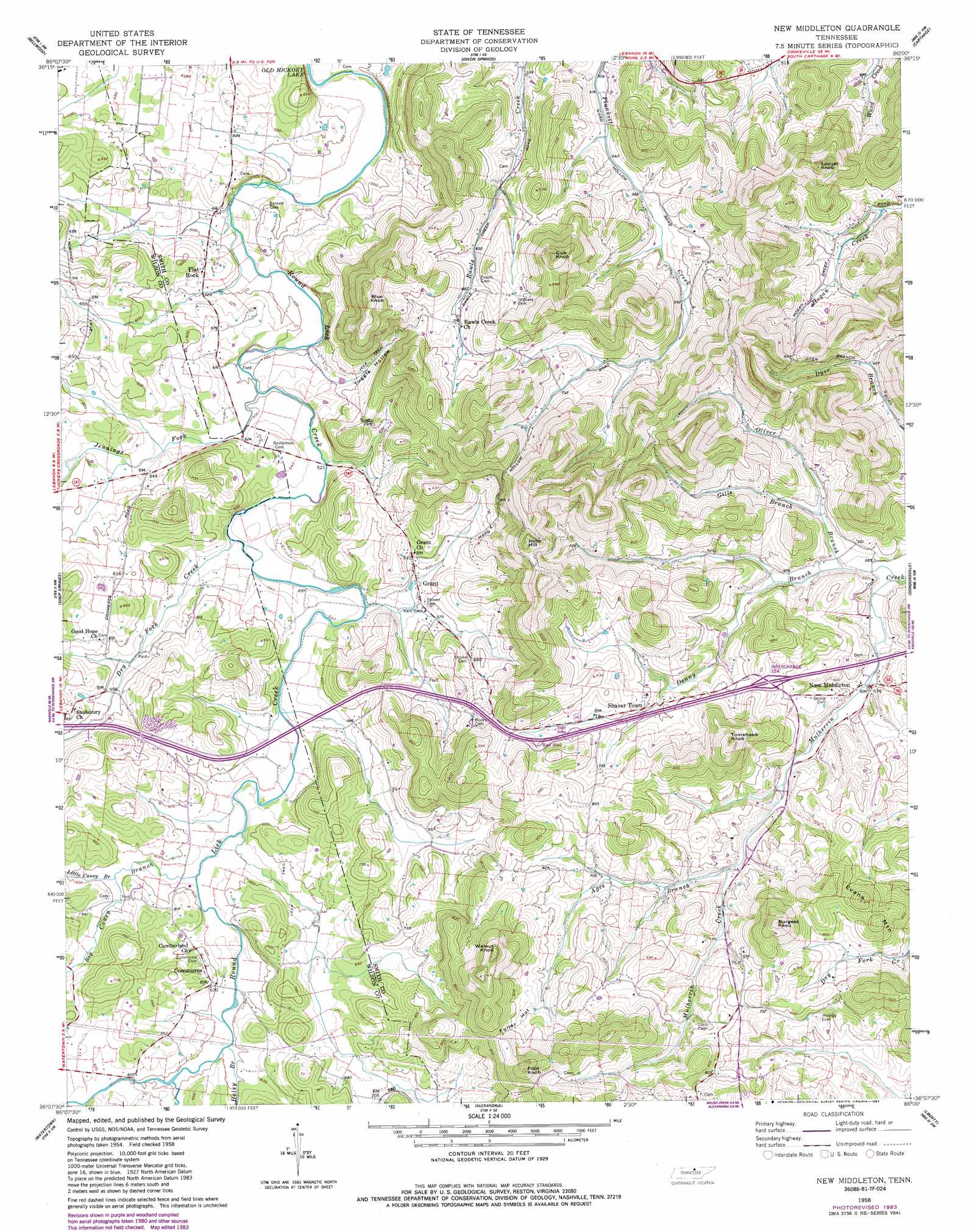
USGS Topo Quad 36086b1 - 1:24,000 scale
| Topo Map Name: | New Middleton |
| USGS Topo Quad ID: | 36086b1 |
| Print Size: | ca. 21 1/4" wide x 27" high |
| Southeast Coordinates: | 36.125° N latitude / 86° W longitude |
| Map Center Coordinates: | 36.1875° N latitude / 86.0625° W longitude |
| U.S. State: | TN |
| Filename: | o36086b1.jpg |
| Download Map JPG Image: | New Middleton topo map 1:24,000 scale |
| Map Type: | Topographic |
| Topo Series: | 7.5´ |
| Map Scale: | 1:24,000 |
| Source of Map Images: | United States Geological Survey (USGS) |
| Alternate Map Versions: |
New Middleton TN 1958 Download PDF Buy paper map New Middleton TN 1958, updated 1959 Download PDF Buy paper map New Middleton TN 1958, updated 1980 Download PDF Buy paper map New Middleton TN 1958, updated 1983 Download PDF Buy paper map New Middleton TN 1994, updated 1997 Download PDF Buy paper map New Middleton TN 2010 Download PDF Buy paper map New Middleton TN 2013 Download PDF Buy paper map New Middleton TN 2016 Download PDF Buy paper map |
1:24,000 Topo Quads surrounding New Middleton
Bethpage |
Hartsville |
Hillsdale |
Pleasant Shade |
Willette |
Hunters Point |
Bellwood |
Dixon Springs |
Carthage |
Granville |
Lebanon |
Shop Springs |
New Middleton |
Gordonsville |
Buffalo Valley |
Vine |
Watertown |
Alexandria |
Liberty |
Center Hill Dam |
Lascassas |
Milton |
Auburntown |
Gassaway |
Smithville |
> Back to 36086a1 at 1:100,000 scale
> Back to 36086a1 at 1:250,000 scale
> Back to U.S. Topo Maps home
New Middleton topo map: Gazetteer
New Middleton: Crossings
Interchange 254 elevation 220m 721′New Middleton: Populated Places
Commerce elevation 189m 620′Flat Rock elevation 169m 554′
Grant elevation 180m 590′
Jennings (historical) elevation 176m 577′
New Middleton elevation 172m 564′
Saulsbury elevation 198m 649′
Shaver Town elevation 212m 695′
New Middleton: Streams
Agee Branch elevation 194m 636′Big Caney Branch elevation 171m 561′
Denny Branch elevation 164m 538′
Dry Fork Creek elevation 158m 518′
Gills Branch elevation 175m 574′
Haley Branch elevation 178m 583′
Jennings Fork elevation 152m 498′
Little Caney Branch elevation 179m 587′
Oliver Branch elevation 170m 557′
New Middleton: Summits
Belle Hill elevation 349m 1145′Blue Knob elevation 315m 1033′
Burgess Knob elevation 334m 1095′
Cub Knob elevation 336m 1102′
Evans Mountain elevation 296m 971′
Locust Knob elevation 311m 1020′
Pilot Knob elevation 359m 1177′
Tomahawk Knob elevation 310m 1017′
Walnut Knob elevation 357m 1171′
New Middleton: Valleys
Fuller Hollow elevation 245m 803′Tuggle Hollow elevation 172m 564′
New Middleton digital topo map on disk
Buy this New Middleton topo map showing relief, roads, GPS coordinates and other geographical features, as a high-resolution digital map file on DVD: